Artaani

Last updated

Artaani (Georgian :არტაანი Art'aani) was a region in historical southwestern Georgia.

Georgian language official language of Georgia

Georgian is a Kartvelian language spoken by Georgians. It is the official language of Georgia. Georgian is written in its own writing system, the Georgian script. Georgian is the literary language for all regional subgroups of Georgians, including those who speak other Kartvelian languages: Svans, Mingrelians and the Laz.

Georgia (country) Country in the Caucasus region

Georgia is a country in the Caucasus region of Eurasia. Located at the crossroads of Western Asia and Eastern Europe, it is bounded to the west by the Black Sea, to the north by Russia, to the south by Turkey and Armenia, and to the southeast by Azerbaijan. The capital and largest city is Tbilisi. Georgia covers a territory of 69,700 square kilometres (26,911 sq mi), and its 2017 population is about 3.718 million. Georgia is a unitary semi-presidential republic, with the government elected through a representative democracy.

history

in 12th century BC region was part of newly formed tribal confederacy of Dieuchi, This federation was powerful enough to counter the Assyrian, later Urartian forays, but, in 760s BC it was finally destroyed and annexed by Colchian incursions, which now found itself facing the hostile Urartu. The Urartian King Sardur II (764–735) led several campaigns against Colchis around 750–741 BC, significantly weakening and exposing it to the attacks of northern tribes. By 720 BC, the Cimmerian incursions from the north destroyed Colchis and significantly affected local society and culture. The first surviving record about this region is attributed to Strabo, who calls it Gogarene (Gugark) and mentions that it was a part of the Kingdom of Armenia, taken away from the Kingdom of Iberia. [1] [2] From the ninth to eleventh centuries, Ardahan served as an important transit point for goods arriving from the Abbasid Caliphate and departing to the regions around the Black Sea. During the eighth to ten centuries the region was in the hands of the Bagrationi princes of Tao and Klarjeti, After the liberation from Arab rule, it was incorporated into the Kingdom of Georgia. According to the Arab historian Yahya of Antioch, the Byzantines razed Ardahan and slaughtered its population in 1021. [2] The Mongols took hold of the region in the 1230s but the Georgian princes of Samtskhe-Saatabago were able to recapture it in 1266.

Diauehi former country

Diauehi or Daiaeni was a tribal union of possibly proto-Georgian and Hurrian groups located in northeastern Anatolia, that was formed in the 12th century BC in the post-Hittite period. It is mentioned in the Urartian inscriptions. It is usually identified with the Yonjalu inscription of the Assyria king Tiglath-Pileser I’s third year. Diauehi is a possible locus of Proto-Kartvelian; it has been described as an "important tribal formation of possible proto-Georgians" by Ronald Grigor Suny (1994). Although the exact geographic extent of Diauehi is still unclear, many scholars place it in the Pasinler Plain in today’s northeastern Turkey, while others locate it in the Turkish–Georgian marchlands as it follows the Kura River. Most probably, the core of the Diauehi lands may have extended from the headwaters of the Euphrates into the river valleys of Çoruh to Oltu. The Urartian sources speak of Diauehi’s three key cities – Zua, Utu and Sasilu; Zua is frequently identified with Zivin Kale and Ultu is probably modern Oltu, while Sasilu is sometimes linked to the early medieval Georgian toponym Sasire, near Tortomi.

Assyria major Mesopotamian East Semitic kingdom

Assyria, also called the Assyrian Empire, was a Mesopotamian kingdom and empire of the ancient Near East and the Levant. It existed as a state from perhaps as early as the 25th century BC until its collapse between 612 BC and 609 BC - spanning the periods of the Early to Middle Bronze Age through to the late Iron Age. From the end of the seventh century BC to the mid-seventh century AD, it survived as a geopolitical entity, for the most part ruled by foreign powers such as the Parthian and early Sasanian Empires between the mid-second century BC and late third century AD, the final part of which period saw Mesopotamia become a major centre of Syriac Christianity and the birthplace of the Church of the East.

Urartu Iron Age kingdom located in a large region around Lake Van

Urartu, which corresponds to the biblical mountains of Ararat, is the name of a geographical region commonly used as the exonym for the Iron Age kingdom also known by the modern rendition of its endonym, the Kingdom of Van, centered around Lake Van in the historic Armenian Highlands.

In 1878, after the Russo-Turkish War (1877–1878), the region was incorporated into the Russian Empire, and until 1918 was known as Kars Oblast. Part of the Democratic Republic of Georgia from 1918 to 1921, Ardahan was reclaimed by Turkey under the Treaty of Kars in 1921.

Russo-Turkish War (1877–1878) conflict of 1877–78

The Russo-Turkish War of 1877–78 was a conflict between the Ottoman Empire and the Eastern Orthodox coalition led by the Russian Empire and composed of Bulgaria, Romania, Serbia, and Montenegro. Fought in the Balkans and in the Caucasus, it originated in emerging 19th-century Balkan nationalism. Additional factors combined Russian goals of recovering territorial losses endured during the Crimean War, re-establishing itself in the Black Sea and supporting the political movement attempting to free Balkan nations from the Ottoman Empire.

Russian Empire Former country, 1721–1917

The Russian Empire, also known as Imperial Russia or simply Russia, was an empire that existed across Eurasia and North America from 1721, following the end of the Great Northern War, until the Republic was proclaimed by the Provisional Government that took power after the February Revolution of 1917.

Kars Oblast oblast

Kars Oblast was one of the oblasts of the Caucasus Viceroyalty of the Russian Empire between 1878 and 1917. Its capital was the city of Kars, presently in the Republic of Turkey. The governorate bordered with the Ottoman Empire, Batum Oblast, Tiflis Governorate, Erivan Governorate, and from 1883 to 1903 the Kutais Governorate. It covered all of Turkey's present provinces of Kars and Ardahan and the northeastern part of Erzurum Province as well as a small part of Armenia.

Related Research Articles

Kars Province Province of Turkey in Northeast Anatolia

Kars Province is a province of Turkey, located in the northeastern part of the country. It shares part of its closed border with the Republic of Armenia. The provincial capital is the city of Kars. The provinces of Ardahan and Iğdır were until the 1990s part of Kars Province.

Akhaltsikhe Place in Samtskhe-Javakheti, Georgia

Akhaltsikhe is a small city in Georgia's southwestern region (mkhare) of Samtskhe–Javakheti. It is situated on the both banks of a small river Potskhovi, which separates the city to the old city in the north and new in the south.

Akhalkalaki Place in Samtskhe-Javakheti, Georgia

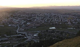
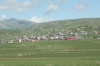
Akhalkalaki is a town in Georgia's southern region of Samtskhe–Javakheti. Akhalkalaki lies on the edge of the Javakheti Plateau. The city is located about 30 kilometres (19 mi) from the border with Turkey. In 2002 over 90 percent of the city's population were ethnic Armenians. The city was passed from Ottomans to Russians after Russo-Turkish War (1828–1829). On January 4, 1900, an earthquake destroyed much of the town and killed 1,000 people in the area. As of the 2014 census the town had a population of 8,295.

Rize Municipality in Turkey

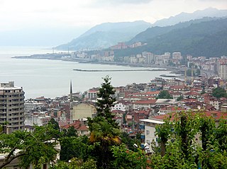
Rize is the capital city of Rize Province in the eastern part of the Black Sea Region of Turkey.

Erzurum Vilayet Ottoman province

The Vilayet of Erzerum was a first-level administrative division (vilayet) of the Ottoman Empire.

Kars Eyalet Ottoman province

The Eyalet of Kars was an eyalet (province) of the Ottoman Empire. Its reported area in the 19th century was 6,212 square miles (16,090 km2).

Childir Eyalet Ottoman province

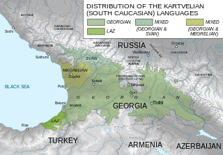
The Eyalet of Childir or Akhalzik was an eyalet of the Ottoman Empire in the Southwestern Caucasus. The area of the former Çıldır Eyalet is now divided between Samtskhe-Javakheti and the Autonomous Republic of Adjara in Georgia and provinces of Artvin, Ardahan and Erzurum in Turkey. The administrative center was Çıldır between 1578-1628, Ahıska between 1628-1829, and Oltu between 1829-1845.

Ardahan Municipality in Turkey

Ardahan is a city in northeastern Turkey, near the Georgian border.

Damal Place in Ardahan, Turkey

Damal, formerly Petereke, is a town and district of Ardahan Province of Turkey, on the road from Kars to Posof.

Göle Place in Ardahan, Turkey

Göle is a small city and surrounding district in Ardahan Province of Turkey. The city was formerly known as Merdenik, Merdinik or Ardahan-ı Küçük.

Hopa Place in Artvin, Turkey

Hopa is a city and district of Artvin Province in northeast Turkey. It is located on the eastern Turkish Black Sea coast about 67 km (42 mi) from the city of Artvin and 18 kilometres from the border with Georgia.

Posof Place in Ardahan, Turkey

Posof is a district of Ardahan Province of Turkey, in the far east of the country, 75 km from the city of Ardahan. It has a border crossing with neighboring Georgia at Türkgözü. Posof is well known for its handicrafts particularly its ornate silver belts and knives.

Yusufeli Place in Artvin, Turkey

Yusufeli is a town and district of Artvin Province in the Black Sea region of Turkey. It is located on the bank of Çoruh River 104 km south-west of the city of Artvin, on the road to Erzurum.

Ninotsminda Town in Samtskhe-Javakheti, Georgia

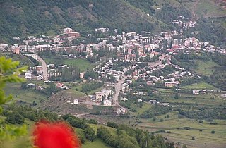
Ninotsminda is a town and a center of the eponymous municipality located in Georgia's southern district of Samtskhe-Javakheti. According to the 2014 census the town has a population of 5,144. The vast majority of the population are Armenians.

Eastern Anatolia Region Region of Turkey

The Eastern Anatolia Region is a geographical region of Turkey.

Caucasus Greeks

The Caucasus Greeks, sometimes known as the Greeks of Trans-Caucasus and Russian Asia Minor, are the historically Greek-speaking peoples of the North Caucasus and Transcaucasia in what is now southwestern Russia, Georgia, and northeastern Turkey. These specifically include the Pontic Greeks, though they today span a much wider region including the Russian north Caucasus, and the former Russian Caucasus provinces of Batum Oblast' and Kars Oblast', now in north-eastern Turkey and Adjara in Georgia.

Şeytan Castle

Şeytan Castle is a castle in the Çıldır district of the Ardahan Province in Turkey.

References

  1. Strabo. Geographica . 11.14.7.
  2. 1 2 (in Armenian) «Արդահան» [Ardahan]. Armenian Soviet Encyclopedia. Yerevan: Armenian Academy of Sciences, 1976, vol. ii, p. 7.