
Crete is the largest and most populous of the Greek islands, the 88th largest island in the world and the fifth largest island in the Mediterranean Sea, after Sicily, Sardinia, Cyprus, and Corsica. Crete rests about 160 km (99 mi) south of the Greek mainland, and about 100 km (62 mi) southwest of Anatolia. Crete has an area of 8,450 km2 (3,260 sq mi) and a coastline of 1,046 km (650 mi). It bounds the southern border of the Aegean Sea, with the Sea of Crete to the north and the Libyan Sea to the south. Crete covers 260 km from west to east but is narrow from north to south, spanning three longitudes but only half a latitude.

Chios is the fifth largest Greek island, situated in the northern Aegean Sea, and the tenth largest island in the Mediterranean Sea. The island is separated from Turkey by the Chios Strait. Chios is notable for its exports of mastic gum and its nickname is "the Mastic Island". Tourist attractions include its medieval villages and the 11th-century monastery of Nea Moni, a UNESCO World Heritage Site.
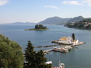
Corfu or Kerkyra is a Greek island in the Ionian Sea, of the Ionian Islands, and, including its small satellite islands, forms the margin of the northwestern frontier of Greece. The island is part of the Corfu regional unit, and is administered by three municipalities with the islands of Othonoi, Ereikoussa, and Mathraki. The principal city of the island is also named Corfu. Corfu is home to the Ionian University.

Naxos is a Greek island and the largest of the Cyclades. It was the centre of the archaic Cycladic culture. The island is famous as a source of emery, a rock rich in corundum, which until modern times was one of the best abrasives available.

Evia also known by its antique spelling Euboea is the second-largest Greek island in area and population, after Crete, and the sixth largest island in the Mediterranean Sea. It is separated from Boeotia in mainland Greece by the narrow Euripus Strait. In general outline it is a long and narrow island; it is about 180 km (110 mi) long, and varies in breadth from 50 km (31 mi) to 6 km (3.7 mi). Its geographic orientation is from northwest to southeast, and it is traversed throughout its length by a mountain range, which forms part of the chain that bounds Thessaly on the east, and is continued south of Euboia in the lofty islands of Andros, Tinos and Mykonos.

Lemnos or Limnos is a Greek island in the northern Aegean Sea. Administratively the island forms a separate municipality within the Lemnos regional unit, which is part of the North Aegean region. The principal town of the island and seat of the municipality is Myrina. At 477.583 square kilometres (184.396 sq mi), it is the 8th-largest island of Greece.

Salamis or Salamina is the largest Greek island in the Saronic Gulf, about two kilometres from the coast of Piraeus and about 16 km west of central Athens. The chief city, Salamina, lies in the west-facing core of the crescent on Salamis Bay, which opens into the Saronic Gulf. On the eastern side of the island is its main port, Paloukia, the second largest port in Greece in terms of size, after the port of Piraeus.

Ios, Io or Nio is a Greek island in the Cyclades group in the Aegean Sea. Ios is a hilly island with cliffs down to the sea on most sides. It is situated halfway between Naxos and Santorini. It is about 18 kilometres long and 10 kilometres wide, with an area of 109.024 square kilometres (42.094 sq mi). Population was 2,299 in 2021. Ios is part of the Thira regional unit.

Icaria, also spelled Ikaria, is a Greek island in the Aegean Sea, 10 nautical miles (19 km) southwest of Samos.
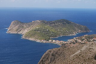
Kefalonia or Cephalonia, formerly also known as Kefallinia or Kephallenia (Κεφαλληνία), is the largest of the Ionian Islands in western Greece and the 6th largest island in Greece after Crete, Euboea, Lesbos, Rhodes and Chios. It is also a separate regional unit of the Ionian Islands region. It was a former Latin Catholic diocese Kefalonia–Zakynthos (Cefalonia–Zante) and short-lived titular see as just Kefalonia. The capital city of Cephalonia is Argostoli.

Zakynthos or Zante is a Greek island in the Ionian Sea. It is the third largest of the Ionian Islands, with an area of 405.55 km2 (156.6 sq mi), and a coastline 123 km (76 mi) in length. The name, like all similar names ending in -nthos, is pre-Mycenaean or Pelasgian in origin. In Greek mythology the island was said to be named after Zacynthus, the son of the legendary Arcadian chief Dardanus.

Kythira is an island in Greece lying opposite the south-eastern tip of the Peloponnese peninsula. It is traditionally listed as one of the seven main Ionian Islands, although it is distant from the main group. Administratively, it belongs to the Islands regional unit, which is part of the Attica region, despite its distance from the Saronic Islands, around which the rest of Attica is centered. As a municipality, it includes the island of Antikythera to the south.

Imbros, officially Gökçeada since 29 July 1970, is the largest island of Turkey, located in Çanakkale Province. It is located in the north-northeastern Aegean Sea, at the entrance of Saros Bay, and has the westernmost point of Turkey. Imbros has an area of 286.8 km2 (110.7 sq mi), and has some wooded areas.

Kalymnos is a Greek island and municipality in the southeastern Aegean Sea. It belongs to the Dodecanese island chain, between the islands of Kos and Leros : the latter is linked to it through a series of islets. Kalymnos lies between two and five hours away by sea from the island of Rhodes.

Alonnisos, also transliterated as Alonissos, is a Greek island in the Aegean Sea. After Skiathos and Skopelos it is the third member of the Northern Sporades. It is 3 km (2 mi) (2 nm) east of the island of Skopelos. Alonnisos is also the name of a village on the island, as well as the municipality that encompasses the island and the village.
Sousta is a Greek folk dance, performed at weddings as an activity of courtship between husband and wife. It originates from Ancient Greece, and holds prominence in Dodecanese Islands, and broader Aegean region. It is the second most common Greek dance, after the Syrtos, with many Greek islands and villages adopting their own version. The performance of the dance reflects various gender roles, inter-played with values of romance and marriage. The Sousta acted as a socialisation process between the youth of a village, evolving into a dance central to these youth as they grew up and formed relationships with others. Socially, the Sousta also functioned as a visible verification of courtship, namely paying respects to the wife and her family. The Sousta is most commonly performed as a three-step dance, with a 'hopping' motion and crossed-over hands.

Kythnos, commonly called Thermia, is a Greek island and municipality in the Western Cyclades between Kea and Serifos. It is 56 nautical miles (104 km) from the Athenian harbor of Piraeus. The municipality Kythnos is 100.187 km2 (38.68 sq mi) in area and has a coastline of about 100 km (62 mi). Mount Kakovolo is island's highest peak (365m).

Agathonísi is a small Greek island and municipality located at the northernmost point of the Dodecanese in Greece. It is surrounded by many smaller islands and is home to two villages, both inland; Megalo Chorio, and Mikro Chorio. Between them is the small settlement of Agios Georgios, which forms the island's only harbor and consists of a few hotels and restaurants. The island is also locally known as Gaidaro ("Donkey"), or by its ancient name Tragea.

Greece is a country in Southeastern Europe, on the Balkan Peninsula. It is bordered to the north by Albania, North Macedonia and Bulgaria; to the east by Turkey, and is surrounded to the east by the Aegean Sea, to the south by the Cretan and the Libyan seas, and to the west by the Ionian Sea which separates Greece from Italy.

Rhodes is the largest of the Dodecanese islands of Greece and is their historical capital; it is the ninth largest island in the overall Mediterranean Sea. Administratively, the island forms a separate municipality within the Rhodes regional unit, which is part of the South Aegean administrative region. The principal town of the island and seat of the municipality is Rhodes. The city of Rhodes had 50,636 inhabitants in 2011. In 2022, the island had a population of 125,113 people. It is located northeast of Crete, southeast of Athens. Rhodes has several nicknames, such as "Island of the Sun" due to its patron sun god Helios, "The Pearl Island", and "The Island of the Knights", named after the Knights of Saint John of Jerusalem, who ruled the island from 1310 to 1522.
