Elgin is a town and formerly a Royal Burgh in Moray, Scotland. It is the administrative and commercial centre for Moray. The town originated to the south of the River Lossie on the higher ground above the floodplain where the town of Birnie is. There, the church of Birnie Kirk was built in 1140 and serves the community to this day.
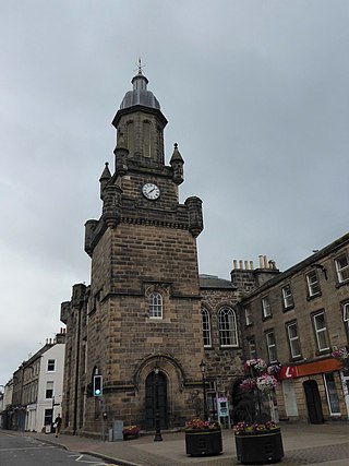
Forres is a town and former royal burgh in the north of Scotland on the Moray coast, approximately 25 miles (40 km) northeast of Inverness and 12 miles (19 km) west of Elgin. Forres has been a winner of the Scotland in Bloom award on several occasions. There are many geographical and historical attractions nearby such as the River Findhorn, and there are also classical, historical artifacts and monuments within the town itself, such as Forres Tolbooth and Nelson's Tower. Brodie Castle, the home of the Brodie Clan, lies to the west of the town, close to the A96.

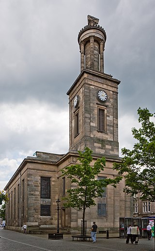
Lossiemouth is a town in Moray, Scotland. Originally the port belonging to Elgin, it became an important fishing town. Although there has been over 1,000 years of settlement in the area, the present day town was formed over the past 250 years and consists of four separate communities that eventually merged into one. From 1890 to 1975, it was a police burgh as Lossiemouth and Branderburgh.

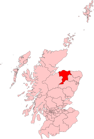
Moray; or Morayshire, called Elginshire until 1919, is a historic county, registration county and lieutenancy area of Scotland, bordering Nairnshire to the west, Inverness-shire to the south, and Banffshire to the east. It was a local government county, with Elgin the county town, until 1975. The county was officially called Elginshire, sharing the name of the Elginshire parliamentary constituency, so named since 1708.
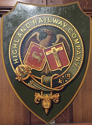
The Highland Railway (HR) was one of the smaller British railways before the Railways Act 1921, operating north of Perth railway station in Scotland and serving the farthest north of Britain. Based in Inverness, the company was formed by merger in 1865, absorbing over 249 miles (401 km) of line. It continued to expand, reaching Wick and Thurso in the north and Kyle of Lochalsh in the west, eventually serving the counties of Caithness, Sutherland, Ross & Cromarty, Inverness, Perth, Nairn, Moray and Banff. Southward it connected with the Caledonian Railway at Stanley Junction, north of Perth, and eastward with the Great North of Scotland Railway at Boat of Garten, Elgin, Keith and Portessie.
Moray is a county constituency of the House of Commons of the Parliament of the United Kingdom. It elects one Member of Parliament (MP) by the first past the post system of election.

Nairn railway station is a railway station serving the town of Nairn in Scotland. The station is managed and served by ScotRail and is on the Aberdeen to Inverness Line, between Forres and Inverness Airport, measured 128 miles 72 chains (207.4 km) from Perth via the former Dava route. It is a category B listed building.

Forres railway station serves the town of Forres, Moray in Scotland. The station is managed and served by ScotRail and is on the Aberdeen–Inverness line, between Nairn and Elgin, measured 119 miles 42 chains (192.4 km) from Perth via the Dava route.

Elgin railway station is a railway station serving the town of Elgin, Moray in Scotland. The station is managed and served by ScotRail and is on the Aberdeen to Inverness Line, between Keith and Forres, measured 12 miles 18 chains (19.7 km) from Forres.

The Morayshire Railway was the first railway to be built north of Aberdeen, Scotland. It received royal assent in 1846 but construction was delayed until 1851 because of the adverse economic conditions existing in the United Kingdom. The railway was built in two phases with the section from Elgin to Lossiemouth completed in 1852. When the Inverness and Aberdeen Junction Railway (I&AJR) reached Keith via Elgin, the Morayshire was able to complete the Speyside second phase by connecting the Craigellachie line at Orton. Initially, the Morayshire ran its own locomotives on the I&AJR track between Elgin and Orton but this was short-lived and the Morayshire carriages were then hauled to Orton by the I&AJR. Disagreements with the I&AJR eventually forced the Morayshire into constructing a new section of track between its stations at Elgin and Rothes; this was completed in 1862. The Morayshire accomplished its final enlargement by connecting to the new Great North of Scotland Railway (GNoSR) Craigellachie station in 1863. Crippling debt forced the company into an arrangement with the GNoSR for it to assume operation of the track in 1866. By 1881, the Morayshire had greatly reduced its liabilities and its long-sought-after amalgamation with the GNoSR finally took place.
The Inverness and Aberdeen Junction Railway (I&AJR) was a railway company in Scotland, created to connect other railways and complete the route between Inverness and Aberdeen. The Inverness and Nairn Railway had opened to the public on 7 November 1855 and the Great North of Scotland Railway (GNoSR) was building from Aberdeen to Keith. The I&AJR opened, closing the gap, on 18 August 1856.
The Scottish North Eastern Counties Constabulary, was one of the two Police Forces which in 1975, were merged to create Grampian Police.
The Muckle Spate was a great flood in August 1829, which devastated much of Strathspey, in the north east of Scotland. Muckle is a Scots word for 'much' or 'great'.
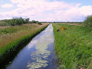
Spynie Canal is a canal in Moray, Scotland, which lies between Elgin and Lossiemouth. It drains into the River Lossie near its mouth at Lossiemouth.
Elgin Caledonian Football Club was a Scottish football team from Elgin, Moray. They participated in the Highland Football League for only one season, in 1900–01, finishing bottom of the league with seven defeats in seven games.
Linksfield Level Crossing railway station or Linksfield railway station served the local rural area just north of Elgin, Moray, Scotland from 1852 to 1859 on the Morayshire Railway. The line joined the Moray Coast Railway at Lossie Junction and trains ran on to the old Elgin (East) railway station.

The Moray Coast Railway was a heavy rail route in Morayshire, Scotland. It was opened in three phases by the Great North of Scotland Railway (GNoSR) between 1884 and 1886. The line ran from the Banff, Portsoy and Strathisla Railway in Portsoy to the Morayshire Railway in Elgin. Trains were operated by the Great North of Scotland Railway until 1923, when the route was taken over by the London and North Eastern Railway (LNER). The LNER operated the route from 1923 until 1948 when Britain's railways were nationalised to form British Railways, who operated the route until its closure in 1968.

Cloddach Bridge is a road bridge south of Elgin that crosses the River Lossie.
Landshut Bridge is a road bridge in Elgin, Moray, Scotland which crosses the River Lossie.
Bishopmill Bridge is a road bridge in Elgin, Moray, Scotland.

