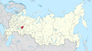
Udmurtia, or the Udmurt Republic, is a federal subject of Russia within the Volga Federal District. Its capital is the city of Izhevsk. Population: 1,521,420.

Abyysky District is an administrative and municipal district, one of the thirty-four in the Sakha Republic, Russia. It is located in the north of the republic around the Indigirka River and borders with Allaikhovsky District in the north, Srednekolymsky District in the east, Verkhnekolymsky District in the southeast, Momsky District in the south, and with Ust-Yansky District in the west. The area of the district is 69,400 square kilometers (26,800 sq mi). Its administrative center is the urban locality of Belaya Gora. As of the 2010 Census, the total population of the district was 4,425, with the population of Belaya Gora accounting for 50.7% of that number.

Allaikhovsky District is an administrative and municipal district, one of the thirty-four in the Sakha Republic, Russia. It is located in the northeast of the republic towards the mouth of the Indigirka River and borders with the East Siberian Sea in the north, Nizhnekolymsky District in the east, Srednekolymsky District in the southeast, Abyysky District in the south, and with Ust-Yansky District in the west. The area of the district is 107,300 square kilometers (41,400 sq mi). Its administrative center is the urban locality of Chokurdakh. As of the 2010 Census, the total population of the district was 3,050, with the population of Chokurdakh accounting for 77.6% of that number.

Aldansky District is an administrative and municipal district, one of the thirty-four in the Sakha Republic, Russia. It is located in the south of the republic on the right bank of the Lena River near the mouth of the Aldan River and borders with Khangalassky and Amginsky Districts in the north, Ust-Maysky District in the northeast, Khabarovsk Krai in the east, Neryungrinsky District in the south, and with Olyokminsky District in the west and southwest. The area of the district is 156,800 square kilometers (60,500 sq mi). Its area is larger than the country of Bangladesh. Its administrative center is the town of Aldan. As of the 2010 Census, the total population of the district was 42,632, with the population of Aldan accounting for 49.9% of that number.
Khangalassky District is an administrative and municipal district, one of the thirty-four in the Sakha Republic, Russia. It is located in the center of the republic and borders Megino-Kangalassky District in the east, Amginsky and Aldansky Districts in the south, Olyokminsky District in the southwest, Gorny District in the northwest, and the territory of the city of republic significance of Yakutsk in the north. The area of the district is 24,700 square kilometers (9,500 sq mi). Its administrative center is the town of Pokrovsk. As of the 2010 Census, the total population of the district, excluding its administrative center, was 24,557.

Megino-Kangalassky District is an administrative and municipal district, one of the thirty-four in the Sakha Republic, Russia. It is located in the central part of the republic, on the Lena River opposite Yakutsk, the capital of the republic. It borders Ust-Aldansky District in the north, Churapchinsky District in the east, Amginsky District in the southeast, Khangalassky District in the southwest, and is bounded by the Lena River in the west. The area of the district is 11,700 square kilometers (4,500 sq mi). Its administrative center is the rural locality of Mayya. As of the 2010 Census, the total population of the district was 31,278, with the population of Mayya accounting for 23,.3% of that number.

Igrinsky District is an administrative and municipal district (raion), one of the twenty-five in the Udmurt Republic, Russia. It is located in the center of the republic. The area of the district is 2,266.9 square kilometers (875.3 sq mi). Its administrative center is the rural locality of Igra. Population: 38,194 (2010 Census); 42,850 ; 45,869 (1989 Census). The population of Igra accounts for 54.3% of the district's total population.

Yakshur-Bodyinsky District is an administrative and municipal district (raion), one of the twenty-five in the Udmurt Republic, Russia. It is located in the center of the republic. The area of the district is 1,780.1 square kilometers (687.3 sq mi). Its administrative center is the rural locality of Yakshur-Bodya. Population: 21,467 (2010 Census); 22,599 ; 22,964 (1989 Census). The population of Yakshur-Bodya accounts for 33.8% of the district's total population.

Uvinsky District is an administrative and municipal district (raion), one of the twenty-five in the Udmurt Republic, Russia. It is located in the southwestern central part of the republic. The area of the district is 2,445.4 square kilometers (944.2 sq mi). Its administrative center is the rural locality of Uva. Population: 39,671 (2010 Census); 40,738 ; 40,876 (1989 Census). The population of Uva accounts for 50.4% of the district's total population.

Yarsky District is an administrative and municipal district (raion), one of the twenty-five in the Udmurt Republic, Russia. It is located in the northwest of the republic. The area of the district is 1,524.3 square kilometers (588.5 sq mi). Its administrative center is the rural locality of Yar. Population: 15,286 (2010 Census); 18,880 ; 20,595 (1989 Census). The population of Yar accounts for 43.2% of the district's total population.

Nizhny Kuranakh is an urban locality in Aldansky District of the Sakha Republic, Russia, located 30 kilometers (19 mi) from Aldan, the administrative center of the district. As of the 2010 Census, its population was 5,901.
Town of district significance is an administrative division of a district in a federal subject of Russia. It is equal in status to a selsoviet or an urban-type settlement of district significance, but is organized around a town ; often with surrounding rural territories.

Lebediny is an urban locality in Aldansky District of the Sakha Republic, Russia, located 26 kilometers (16 mi) from Aldan, the administrative center of the district. As of the 2010 Census, its population was 1,058.
Leninsky is an urban locality in Aldansky District of the Sakha Republic, Russia, located 6 kilometers (3.7 mi) from Aldan, the administrative center of the district. As of the 2010 Census, its population was 1,866.
Aykhal is an urban locality in Mirninsky District of the Sakha Republic, Russia, located 469 kilometers (291 mi) from Mirny, the administrative center of the district, in the basin of the Vilyuy River. As of the 2010 Census, its population was 13,727.
Almazny is an urban locality in Mirninsky District of the Sakha Republic, Russia, located 20 kilometers (12 mi) from Mirny, the administrative center of the district, on the border of the Lena and Vilyuy Plateaus, on the Irelyakh River, at its confluence with the Ochchuguy-Botuobuya, a tributary of the Vilyuy. As of the 2010 Census, its population was 1,527.
Delyankir is a rural locality under the administrative jurisdiction of the Settlement of Artyk in Oymyakonsky District of the Sakha Republic, Russia, located 44 kilometers (27 mi) from Artyk on the Kolyma Highway on the border with Magadan Oblast. Its population as of the 2010 Census was three people, down from four recorded during the 2002 Census.

Peleduy is an urban locality in Lensky District of the Sakha Republic, Russia, located 199 kilometers (124 mi) from Lensk, the administrative center of the district, on the left bank of the Lena River. As of the 2010 Census, its population was 5,243.
Solnechny is an urban locality in Ust-Maysky District of the Sakha Republic, Russia, located 266 kilometers (165 mi) from Ust-Maya, the administrative center of the district. As of the 2010 Census, its population was 1,034.

