Arundel Friary was a friary in West Sussex, England.
Arundel Friary was a friary in West Sussex, England.
Boxgrove Priory is a ruined priory in the village of Boxgrove in Sussex, England. It was founded in the 12th century.

Arundel is a town in York County, Maine, United States. At the 2020 census, the population was 4,264. It is part of the Portland–South Portland–Biddeford, Maine Metropolitan Statistical Area. The Municipality of Arundel includes the constituent communities and neighbourhoods of: Arundel Village, Vinegar Hill, Riverside Arundel, Log Cabin Crossing, Goff Mill, Millers Crossing, and Cottagehill, among other neighbourhoods in an inland area adjacent to the Towns of Kennebunkport and Biddeford. In 2014, Arundel was named “Best Place to Live in Maine” by Downeast Magazine.
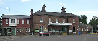
Arundel railway station serves the market town of Arundel in West Sussex. The station is on the eastern side of the town, about 550 yards (500 m) from the High Street, across the River Arun. It is 58 miles 28 chains (93.9 km) down the line from London Bridge via Redhill.
Arundel Football Club is a football club based in Arundel, West Sussex, England. They are currently members of the Southern Combination Division One and play at Mill Road.

The Principality of Outer Baldonia is a defunct micronation that claimed sovereignty over approximately 4 acres (16,000 m2) of Outer Bald Tusket Island, the southernmost of the Tusket Islands off the southern tip of the Canadian province of Nova Scotia.

The Arundel Formation, also known as the Arundel Clay, is a clay-rich sedimentary rock formation, within the Potomac Group, found in Maryland of the United States of America. It is of Aptian age. This rock unit had been economically important as a source of iron ore, but is now more notable for its dinosaur fossils. It consists of clay lenses within depressions in the upper part of the Patuxent Formation that may represent oxbow swamp facies. It is named for Anne Arundel County, Maryland.

Arundel Castle Cricket Ground is a cricket ground in Arundel, West Sussex, England, nearby to Arundel Castle. It has been in use since 1952. The ground was first used by the Sussex 1st XI in 1972 for limited-over matches and in 1990 for County Championship matches. As of the end of the 2015 English cricket season, Arundel Castle has hosted 32 first-class matches, 20 List A matches, and 5 T20 matches.
General's Highway Corridor Park is located at 1758 Crownsville Road, in the town of Crownsville, Maryland, United States. It is located near the site of the annual Maryland Renaissance Festival in the heart of Anne Arundel County.

Arundel & Wick is an electoral division of West Sussex in the United Kingdom and returns one member to sit on West Sussex County Council.
Bodmin Friary was a Franciscan friary in Bodmin, Cornwall, England, UK. There are very few remains from the substantial Franciscan Friary established c. 1240: a gateway in Fore Street and two pillars elsewhere in the town.
Exeter Grey Friary was a friary in Devon, England.
Greyfriars, Beverley was a Franciscan monastery in the East Riding of Yorkshire, England. It was established before 1267, probably by John de Hightmede, but the exact date is not known. Originally located within the town walls near today's St Mary's Terrace, it was moved outside Keldgate, near Westwood, about 1297. Having fallen in disrepair in the 1330s, the knight Sir John Hotham of Scorbrough provided funds for its rebuilding in the 1350s. Several members of his family were buried there later. The friary benefitted further from grants made by nobles and merchants. The friars acknowledged royal supremacy in 1534, and the monastery was surrendered to the Bishop of Dover on 25 February 1538–39. Although no buildings of the friary have survived, it is remembered by the street name "Greyfriars Crescent".
Friary of the Sack, Rye was a friary in East Sussex, England.
Whitefriars, also known as White Friers or The College of Carmelites, Gloucester, England, was a Carmelite friary of which nothing now survives.

Greyfriars, Stamford was a Franciscan friary in Lincolnshire, England. It was one of several religious houses in Stamford suppressed in the Dissolution of the Monasteries.

Boston Friary refers to any one of four friaries that existed in Boston, Lincolnshire, England.
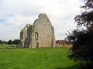
The Priory of St Nicholas was established at Arundel in West Sussex, England by Roger de Montgomery, earl of Shrewsbury, in 1102, when Gratian, a monk of Sées in Normandy, became first prior. In 1269, the priory granted Master William de Wedon, in return for various gifts, board and lodging, and a room in the priory in which he might conduct a school.
Tickhill Friary was an Augustinian friary in Tickhill, South Yorkshire, England. John Clarel, a canon of Southwell, founded it about 1260. It was dissolved in 1530. The remains are a Grade II* listed monument. The 14th century buildings were converted into dwellings in the 17th century, extensions followed in the 19th century. Until 1538, the Fitzwilliam tomb was located in the friary church, but was then moved into the parish church.

St Edmund's Church is the Roman Catholic parish church of Godalming, a town in the English county of Surrey. It was built in 1906 to the design of Frederick Walters and is a Grade II listed building. The church stands on a "dramatic hillside site" on the corner of Croft Road just off Flambard Way close to the centre of the town.

Arundel Park is a 134-hectare (330-acre) biological Site of Special Scientific Interest north of Arundel in West Sussex.
Coordinates: 50°51′14″N0°33′09″W / 50.854015°N 0.552476°W
| | This article about a West Sussex building or structure is a stub. You can help Wikipedia by expanding it. |
| | This article about a British Christian monastery, abbey, priory or other religious house is a stub. You can help Wikipedia by expanding it. |