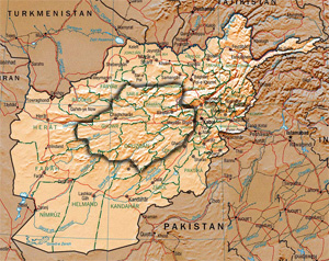
Hazāristān or Hazārajāt is a mountainous region in the central highlands of Afghanistan, among the Koh-i-Baba mountains in the western extremities of the Hindu Kush. It is the homeland of the Hazara people who make up the majority of its population. "Hazārajāt denotes an ethnic and religious zone rather than a geographical one—that of Afghanistan's Turko-Mongol Shiʿites." Hazarajat is primarily made up of the provinces of Bamyan, Daykundi, Ghor and large parts of Ghazni, Urozgan, Parwan and Wardak. The most populous towns in Hazarajat are Bamyan, Yakawlang (Bamyan), Nili (Daykundi), Lal wa Sarjangal (Ghor), Sang-e-Masha (Ghazni), Gizab (Urozgan) and Behsud (Wardak). The Kabul, Arghandab, Helmand, Farah, Hari, Murghab, Balkh and Kunduz rivers originate in Hazarajat.

The Hajigak Pass is situated at a height of 3,700 metres (12,100 ft) above sea-level in the northern part of Maidan Wardak province, connecting it with Bamyan province to the northwest. It is one of the two main routes from Kabul to Bamyan in Hazarajat, leading across the Koh-i-Baba range.

Kahmard is a district of Bamyan Province in central Afghanistan. It is located at an altitude of 1,475 meters, with a population of 31,042. Kahmard is situated 140 km from Bamiyan city, in the north of the province, and is divided into five valleys.
Saighan District is part of Bamyan Province, Afghanistan. As of 2003 it has a population of 23,215. It was created in 2005 from part of Kahmard District, and until 2004 was part of Baghlan Province. Saighan town is the largest town and the administrative center. The district has an area of 1,741 km2 and contains sixty-two villages. Neighboring districts are Bamyan District to the south, Yakawlang District to the west, Kahmard District to the north, and Shibar District to the east.
Shahristan ( is a district in Daykundi Province, Afghanistan. Daykundi var established as a province in the distant north area in Uruzgan province in 2004,
Panjab district is in the central part of Bamiyan Province, Afghanistan. The capital is the town of Panjab. Panjab contains 5 valleys, the water running through the 5 valleys meet in the centre of the district. Its population is entirely Hazara people.
Shibar District is located in the western end of the Bamyan Province in Afghanistan. It is in a mountainous region. The main village Shibar is at 2,637 m altitude on the all-seasons secondary road from Bamyan to Kabul through the Shibar pass.
Waras (Varas) District is a mountainous district in the southern part of Bamyan Province, Afghanistan. Its population is 76,398 people (2011), who are entirely Hazara, according to AIMS data. The main village is Waras. It is situated at 2,794 m altitude.
Yakawlang District is located in the northwestern part of Bamyan Province. Its population is 76,897 (2011) predominantly from the Hazara ethnic group. The capital city Yakawlang formerly held 60,000 residents, and it was completely destroyed by Taliban forces in 2001. Massacres of civilians by the Taliban were reported by Human Rights groups.
There is a gravel surfaced airport near the city.
Bamyan is a district of Bamyan Province in Afghanistan. In 2003, the population was put at 70,028, of which the majority group is Hazara while the Tajik is a minority group. New Zealand peace keepers operate in the district as well as most of Bamyan Province.
Daizangi, , is one of the major tribe of the Hazaras of Hazarajat in central Afghanistan. They inhabit the Bamyan, Yakawlang, Panjab and Waras districts of Bamyan Province, the Shahristan in Daikundi Province, Lal Wa Sarjangal District in Ghor Province and the Gizab District in Uruzgan Province. They are said to be the largest tribe of the Hazaras. The 19th-century Hazara Mir Elkhani,Mir Naser Baig, Mir (Chieftain) Mir Azeem Beg was the mir of the Daizangi who led the final battle of the Hazaras against the Afghan Amir in the battle of Urozgan. He was exiled to Bokhara in present day Uzbekistan, where he wrote his memoirs "Yad e Guzishta", Memories of the past. Most Notable person from the Daizangi tribe is General Khudadad Khan.Their subtribes include the Bubali, Gedi, Kamyaba, Kut-daghi, Khushamadi, Kirigu, Miramur, Qaraqul Daghi, Sag Deh, Sag Jui, Sag-Pae, Sehpai, Takana, Takash, Urarus, and Yangur.
Punjab is the capital of Panjab District - a mountainous district in the southwestern part of the Bamyan Province, Afghanistan. The town is situated at 34°23'N 67°1'E and has an altitude of 2,758 m altitude, the population was 9,900 in the year 2004. There is an airport with gravel surface.
`Ambar Samuch is a village in Bamyan District of Bamyan Province in northern-central Afghanistan.
Deh Hezareh is a village in Bamyan Province in central Afghanistan.
Katok is a village in Bamyan Province in central Afghanistan.
Langar, Bamyan is a village in Bamyan Province in central Afghanistan.


