Related Research Articles

Leicestershire is a ceremonial and non-metropolitan county in the East Midlands, England. The county borders Nottinghamshire to the north, Lincolnshire to the north-east, Rutland to the east, Northamptonshire to the south-east, Warwickshire to the south-west, Staffordshire to the west, and Derbyshire to the north-west. The border with most of Warwickshire is Watling Street, the modern A5 road.

Ashby de la Zouch, sometimes hyphenated as Ashby-de-la-Zouch, and shortened locally to Ashby, is a market town and civil parish in the North West Leicestershire district of Leicestershire, England. The town is near to the Derbyshire and Staffordshire borders. Its 2001 census population of 11,410 rose to 12,370 in 2011. The castle in the town was an important fort in the 15th–17th centuries. In the 19th century the town's main industries were ribbon manufacture, coal mining, and brickmaking.

Ashby de la Zouch Castle is a ruined fortification in the town of Ashby-de-la-Zouch, Leicestershire, England. The castle was built by William, Lord Hastings, a favourite of Edward IV, after 1473, accompanied by the creation of a 3,000-acre (1,200 ha) park. Constructed on the site of an older manor house, two large towers and various smaller buildings had been constructed by 1483, when Hastings was executed by Richard, Duke of Gloucester. The Hastings family used the castle as their seat for several generations, improving the gardens and hosting royal visitors.
The National Forest is an environmental project in central England run by The National Forest Company. From the 1990s, 200 square miles (520 km2) of north Leicestershire, south Derbyshire and southeast Staffordshire have been planted in an attempt to blend ancient woodland with newly planted areas to create a new national forest. It stretches from the western outskirts of Leicester in the east to Burton upon Trent in the west, and is planned to link the ancient forests of Needwood and Charnwood.

Donisthorpe is a village in the North West Leicestershire district of Leicestershire, England, historically an exclave of Derbyshire.

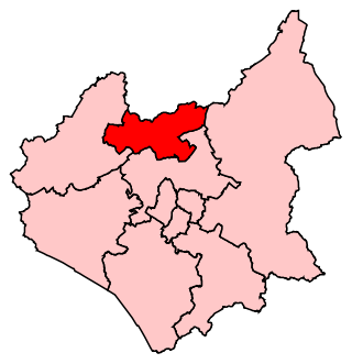
North West Leicestershire is a local government district in Leicestershire, England. The population of the Local Authority at the 2011 census was 93,348. Its main towns are Ashby-de-la-Zouch, Castle Donington, Coalville and Ibstock.
West Goscote was a hundred of Leicestershire, that arose from the division of the ancient Goscote hundred into two. It covers the north west of the county, an area broadly corresponding to the western part of Charnwood district along with North West Leicestershire.
Loughborough is a constituency in Leicestershire represented in the House of Commons of the UK Parliament since 2019 by Jane Hunt, a Conservative. From 2010 until 2019, it was represented by Nicky Morgan, who served in the governments of David Cameron and Boris Johnson. In 2020, she was elevated to the Peerage and became a member of the House of Lords. The constituency is a considered a bellwether, as it has reflected the national result at every general election since February 1974.
Ashby de la Zouch Rural District was a rural district in England, near Ashby de la Zouch. It was formed in 1894 along with most other rural districts. In 1974 it was abolished under the Local Government Act 1972, to form the non-metropolitan district of North West Leicestershire.

Ashby Woulds is a civil parish in Leicestershire, England. The population at the 2011 census was 3,763. It is in the North West Leicestershire district, to the west of Ashby de la Zouch. The main settlements in the parish are Moira and Norris Hill.
Snarestone is a small rural village in North West Leicestershire, England.

Shackerstone is a village and civil parish in the Hinckley and Bosworth district of Leicestershire, England. It is situated on the Ashby-de-la-Zouch Canal and the River Sence. According to the 2001 census the parish, which also includes the village of Barton in the Beans, had a population of 811, including Odstone which had risen to 921 at the 2011 census.

Moira Furnace is a nineteenth-century iron-making blast furnace located in Moira, Leicestershire, on the banks of the Ashby-de-la-Zouch Canal. Built by the Earl of Moira in 1804, the building has been preserved by North West Leicestershire District Council as a museum featuring lime kilns and craft workshops.

The Melbourne Line was a railway line which ran from Derby to Ashby de la Zouch. It was used by the British Army and Allied engineers during the Second World War from 1939 until late 1944 to prepare them for the invasion of mainland Europe. Engineers practised the demolition and rebuilding of railways and the running and maintenance of a railway line and its rolling stock. There was also a bridge building school at Kings Newton.
The Bath Grounds is a historic recreational ground and cricket ground based in the town of Ashby-de-la-Zouch, Leicestershire. It is home to Ashby Hastings Cricket Club and Ashby Bowls Club. The grounds are subject to conservation area protection. and are designated a "sensitive area" in retained policy E1 of the most recent Local Plan.

Swannington is a former mining village situated between Coalville and Ashby-de-la-Zouch, Leicestershire, England. A document of 1520 mentions five pits at Swannington. It was a terminus of the early (1832) Leicester and Swannington Railway that was built to carry away chcvdidvdvdopened in 1825 to serve the townships of Swannington and Thringstone and is built on a spot reputedly chosen by William Wordsworth, a frequent guest of Sir George Beaumont of nearby Coleorton Hall. It is possible that the dedication of the church to Saint George is derived from its association with this George Beaumont.

Coleorton is a village and civil parish in North West Leicestershire, England. It is situated on the A512 road approximately 2 miles (3.2 km) east of Ashby de la Zouch. Nearby villages include Newbold, to the north, Thringstone to the east, and Swannington to the south-east.
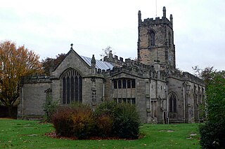
St Helen's Church is the Anglican parish church of Ashby-de-la-Zouch, in the deanery of North West Leicestershire and the Diocese of Leicester. There was a church in the town in the 11th century, but the core of the present building mainly dates from work started in 1474, when the church was rebuilt by William Hastings at the same time that he converted his neighbouring manor house into a castle. The church was refurbished in about 1670 to create more space, but the large and increasing size of the congregation led to further work in 1829, and a major rebuild in 1878–80, including the widening of the nave by the addition of two outer aisles.
Ashby Ivanhoe Football Club are a football club based in Ashby-de-la-Zouch, Leicestershire, England. They are currently members of the Midland League Division One and play at the NFU Sports Ground.

Ashby-de-la-Zouch Town Hall is a municipal building in Market Street in Ashby-de-la-Zouch, Leicestershire, England. The structure, which was used as the offices of Ashby-de-la-Zouch Urban District Council, is a Grade II listed building. The market hall, which is located behind the town hall, is separately listed.
References
- ↑ "Ashby de la Zouch Museum". Leicestershire and Rutland Heritage Forum.
- ↑ "Ashby De La Zouch Museum". Culture 24.
- ↑ "Ashby de la Zouch Museum". Community Archives and Heritage Group.