Atlanta's second airport

Last updated

Atlanta's second airport was an idea being studied by the city of Atlanta, Georgia, United States.

Contents

Studies

In May 2007, the Federal Aviation Administration (FAA) released the report, Capacity Needs in the National Airspace System, 2007–2025 as part of its Future Airport Capacity Task (FACT2). [1] The report identified Hartsfield-Jackson Atlanta International Airport and the Atlanta metropolitan area as needing additional capacity by 2025. [2] Following the report release, Atlanta was given a $1 million federal grant to study the possibility of adding another airport. [3]

Both Atlanta and Delta Air Lines, which operates its primary hub there, expressed skepticism about building a second airport [3] [4] because it would like be expensive and an economic failure, according to Delta. [5]

In 2011, the Atlanta Metropolitan Aviation Capacity Study, Phase II was completed by the FAA, the City of Atlanta and a consulting team. [6] The study concluded that Dobbins Air Reserve Base was the best site from a market potential and development cost perspective, however, the airspace and environmental aspects were problematic. The second best possible site was Cobb County Airport due to its accessibility, yet the high development costs were prohibitive. [6]

In 2014, Hartsfield-Jackson Atlanta International Airport unveiled its 20-year Master Expansion Plan to adequately cover the air travel capacity needs in the Atlanta area through 2035. [7] [ unreliable source? ] [8]

Alternatives

An additional commercial airport for the Atlanta metropolitan area could be created by expansion of an existing general aviation airport, conversion of an air force base or by new construction on a greenfield site.

Silver Comet Field at Paulding Northwest Atlanta Airport

In 1975, in anticipation of a second airport, the City of Atlanta purchased 10,165 acres (4,114 ha) of land west of the city in Paulding County for $925 per acre ($2,290/ha). [9] In early 2007 Paulding County purchased 162 acres (66 ha) of the property for a new general aviation airport (opened in 2009 as Paulding County Regional Airport), however Atlanta's second commercial airport could still be built on the remaining property. [9] Paulding County is unserved by either rapid transit or freeways.

Dawson Forest

Road in Dawson Forest Dawson Forest road 1.JPG
Road in Dawson Forest

The City of Atlanta also owns 10,130 acres (4,100 ha) of land located southwest of Dawsonville, Georgia, which was purchased in 1972 from Lockheed, and was the previous site of the Georgia Nuclear Aircraft Laboratory (GNAL). [10] The property is currently referred to as the Dawson Forest City of Atlanta Tract, and managed by the Georgia Forestry Commission with a trail system open to the public. [11] The tract is located approximately 10 miles (16 km) from the end of limited access on State Route 400 north of Cumming, Georgia. An area of 3 acres (1.2 ha) previously occupied by GNAL was restricted following 1978 testing which found residual nuclear radiation from the experiments performed there. Subsequent studies in 1991 and 1997 found radiation levels to be at or slightly above normal background levels. [10] The property also encompasses Amicalola Creek, which various groups are lobbying to be designated as a scenic river. The forest has also been proposed for use as a major reservoir for the city of Atlanta water system.

Chattanooga Metropolitan Airport

Chattanooga Metropolitan Airport (CHA) officials and a Georgia state senator have proposed expansion of the airport, located in Chattanooga, Tennessee, as a solution to Atlanta's capacity needs. [12] Sen. Jeff Mullis's idea includes a maglev train to connect Atlanta passengers to CHA. [12] Like the Western and Atlantic Railroad (Georgia's first state railroad), it would be built cooperatively by the state with the help of Tennessee. Chattanooga's airport currently operates at a small portion of its capacity, but additional capacity would be necessary to be Atlanta's second airport. Expansion would be difficult as the property is currently bounded by significant roads, a railroad line and a creek bed. [12]

Dobbins Air Reserve Base

Dobbins Air Reserve Base, located just northwest of Atlanta along Interstate 75, was originally intended as a second civilian airport prior to World War II. However, Dobbins would only be available if a future Department of Defense Base Realignment and Closure commission decided to close the base. As of 2015, no additional BRAC commission is planned.

Northeast Georgia Regional Airport

After the announcement of the second airport study, a long-dormant commission created in 1989 by the Georgia General Assembly in hopes of creating a regional airport to northeast Georgia reconstituted itself. [13] The Northeast Georgia Surface and Air Transportation Commission is now planning to create studies for a 20- or 24-gate airport in the region that could provide relief for Hartsfield drawing traffic from Atlanta's northeast suburbs. While the earlier incarnation of the commission narrowed options to the expansion of Gwinnett County's Briscoe Field, the Dawson Forest site, and a 10,000-acre (4,000 ha) site in Jackson County, the new version will consider expansion of the Barrow County-based general aviation Northeast Georgia Regional Airport. [13] The facility is extending an existing runway to 7,000 feet (2,100 m) and although it currently occupies only 450 acres (180 ha), there is adjacent undeveloped land for expansion.

Related Research Articles

<span class="mw-page-title-main">Hartsfield–Jackson Atlanta International Airport</span> International airport in Atlanta, Georgia, United States

Hartsfield–Jackson Atlanta International Airport, also known as Atlanta Hartsfield–Jackson International Airport, Atlanta Airport, Hartsfield, Hartsfield–Jackson and, formerly, as the Atlanta Municipal Airport, is the primary international airport serving Atlanta, Georgia, United States. The airport is located 10 mi (16 km) south of the Downtown Atlanta district. It is named after former Atlanta mayors William B. Hartsfield and Maynard Jackson. ATL covers 4,700 acres (1,900 ha) of land and has five parallel runways. Hartsfield-Jackson Airport has been the world's busiest airport by passenger traffic since 1998, with over 93.6 million passengers.

<span class="mw-page-title-main">Atlantic Southeast Airlines</span> Former regional U.S. airline based in College Park, Georgia (1979–2010)

Atlantic Southeast Airlines (ASA) was a regional U.S. airline based in the A-Tech Center in College Park, Georgia, flying to 144 destinations as a Delta Connection carrier on behalf of Delta Air Lines via a code sharing agreement and, as of February 2010, commenced service as a United Express carrier on behalf of United Airlines via a separate code sharing agreement. It was a wholly owned subsidiary of SkyWest, Inc. ASA operated nearly 900 flights each day. Its main hub was located at Hartsfield–Jackson Atlanta International Airport (ATL) which is also a hub for Delta. After a 2010 merger with ExpressJet, ASA adopted the ExpressJet name and branding in 2011.

<span class="mw-page-title-main">Gainesville Regional Airport</span> Airport in within Gainesville municipal boundary

Gainesville Regional Airport is a public airport three miles northeast of Gainesville, in Alachua County, Florida, United States. It is owned by Gainesville-Alachua Co. Auth. The National Plan of Integrated Airport Systems for 2011–2015 categorized it as a primary commercial service airport.

<span class="mw-page-title-main">Savannah/Hilton Head International Airport</span> Airport in Georgia, United States

Savannah/Hilton Head International Airport is a commercial and military-use airport in Savannah, Georgia, United States. Savannah/Hilton Head International provides travelers with access to Savannah, Georgia, and Hilton Head Island, South Carolina, as well as neighboring areas including Bluffton and Beaufort, South Carolina and the Golden Isles region of Coastal Georgia.

<span class="mw-page-title-main">Cobb County International Airport</span> Airport in Kennesaw, Georgia

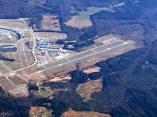
Cobb County International Airport - McCollum Field is a public airport located 21 miles (34 km) northwest of the central business district of Atlanta, immediately south of the city of Kennesaw in Cobb County, Georgia, United States. It operates 24 hours per day, although it is not controlled between the hours of midnight and 6:00 a.m. (EST/EDT). It is also designated as a weather station.

<span class="mw-page-title-main">Gwinnett County Airport</span> Airport in Lawrenceville, Georgia, United States of America

<span class="mw-page-title-main">Dobbins Air Reserve Base</span> Military base in Georgia, USA

Dobbins Air Reserve Base or Dobbins ARB is a United States Air Force reserve air base located in Marietta, Georgia, a suburb about 20 miles (32 km) northwest of Atlanta. Originally known as Dobbins Air Force Base, it was named in honor of Captain Charles M. Dobbins, a World War II C-47 pilot who died near Sicily.

<span class="mw-page-title-main">Fulton County Airport (Georgia)</span> County Airport in Georga, United States

Fulton County Airport, also known as Charlie Brown Field or Brown’s Field, is a county-owned, public-use airport in Fulton County, Georgia, United States. It is located six nautical miles west of the central business district of Atlanta. The airport's name comes from the nickname of former Atlanta politician Charles M. Brown, who served on the city council and county commission during the 1960s. It is also called Charlie Brown Airport or Brown Field. On the radio, however, it is referred to as "County Tower" or "County Ground".

<span class="mw-page-title-main">DeKalb–Peachtree Airport</span> Airport in the United States

DeKalb–Peachtree Airport is a county-owned, public-use airport in DeKalb County, Georgia, United States. The airport is located in the city of Chamblee, just northeast of Atlanta. It is also known commonly as Peachtree–DeKalb Airport, or simply PDK. Other names include Peachtree Airport, DeKalb Airport, or DeKalb County Airport. ASOS weather reports are produced 24 hours per day as "Chamblee". It has airline service with Ultimate Air Shuttle to Cincinnati and Southern Airways Express to Memphis and Destin.

<span class="mw-page-title-main">General Lucius D. Clay National Guard Center</span>

General Lucius D. Clay National Guard Center is a military facility located 1-mile (1.6 km) south of Marietta, Georgia, United States. It is located immediately south of Dobbins Air Reserve Base and shares its runways.

<span class="mw-page-title-main">Chattanooga Metropolitan Airport</span> Airport in Chattanooga, Tennessee

Chattanooga Metropolitan Airport is 5 miles (8 km) east of downtown Chattanooga, in Hamilton County, Tennessee, United States. The airport is owned and operated by the Chattanooga Metropolitan Airport Authority. It is a Class C airport serviced by the Chattanooga Airport Traffic Control Tower. The Federal Aviation Administration (FAA) National Plan of Integrated Airport Systems for 2019–2023 categorized it as a small-hub primary commercial service facility.

<span class="mw-page-title-main">Valdosta Regional Airport</span> Airport

Valdosta Regional Airport is a public-use airport located three nautical miles (6 km) south of the central business district of Valdosta, a city in Lowndes County, Georgia, United States. It is owned by the Valdosta-Lowndes County Airport Authority. The Valdosta Regional airport is mostly used for general aviation, but is also served by Delta Air Lines, which offers service to Atlanta. The airport also offers free parking.

Greenbrier Valley Airport is three miles north of Lewisburg in Greenbrier County, West Virginia. Contour Airlines schedules airline flights, subsidized by the Essential Air Service program, to Charlotte Douglas International Airport. Federal Aviation Administration records say the airport had 7,153 passenger boardings (enplanements) in calendar year 2008, 4,651 in 2009 and 12,293 in 2010. The National Plan of Integrated Airport Systems for 2011–2015 called it a non-primary commercial service airport based on enplanements in 2008/2009.

<span class="mw-page-title-main">Northeast Alabama Regional Airport</span> Airport

Northeast Alabama Regional Airport is five miles southwest of Gadsden, in Etowah County, Alabama. It is owned by Gadsden Airport Authority and it used to be Gadsden Municipal Airport. The FAA's National Plan of Integrated Airport Systems for 2009–2013 categorized as a general aviation facility.

The transportation system of Georgia is a cooperation of complex systems of infrastructure comprising over 1,200 miles (1,900 km) of interstates and more than 120 airports and airbases serving a regional population of 59,425 people.

St. Marys Airport was a public use airport located two nautical miles north of the central business district of St. Marys, a city in Camden County, Georgia, United States. It is owned by the St. Mary's Airport Authority.

<span class="mw-page-title-main">Paulding Northwest Atlanta Airport</span> Airport in Dallas, Georgia

Paulding Northwest Atlanta Airport is a small public-use airport in Paulding County, Georgia, United States. The airport is located in the city of Dallas, Georgia, 30 miles (48 km) northwest of Atlanta. It is owned by the Paulding County Board of Commissioners, and is included in the National Plan of Integrated Airport Systems for 2011–2015, which categorized it as a general aviation facility.

<span class="mw-page-title-main">Dawson Forest</span>

Dawson Forest is a 10,130-acre (41.0 km2) public-use forest located in Dawson County, Georgia, southwest of Dawsonville. It is owned by the city of Atlanta, but is considered a state forest, as it is managed by the Georgia Forestry Commission.

<span class="mw-page-title-main">Delta TechOps</span> Delta Air Lines Technical Operations facility in Atlanta, Georgia, United States

Delta TechOps is the maintenance, repair and overhaul (MRO) division of Delta Air Lines, headquartered at Hartsfield-Jackson International Airport in Atlanta, Georgia. With more than 9,600 employees and 51 maintenance stations worldwide, Delta TechOps is a full-service maintenance provider for the more than 900 aircraft that make up the Delta Air Lines fleet. In addition to maintaining the Delta Air Lines fleet, Delta TechOps also provides MRO solutions and support to more than 150 third-party operators around the world, making it the second largest MRO provider in North America and the seventh largest worldwide.

References

  1. Capacity Needs in the National Airspace System, 2007–2025 (PDF). Federal Aviation Administration. May 14, 2007. p. 16. Archived from the original (PDF) on May 27, 2010. Retrieved October 12, 2007.
  2. Christensen, Tracey (May 15, 2007). "FAA Recommends 2nd Atlanta Airport". WXIA-TV. Retrieved October 12, 2007.[ permanent dead link ]
  3. 1 2 Ramos, Rachel Tobin (May 15, 2007). "Feds give Atlanta $1M to study second metro airport". Atlanta Business Chronicle. Retrieved October 12, 2007.
  4. Mutzabaugh, Ben (May 17, 2007). "Delta, AirTran greet proposal for 2nd Atlanta airport with 'chilly skepticism'". USA Today. Archived from the original on September 16, 2008. Retrieved October 12, 2007.
  5. Mutzabaugh, Ben (October 7, 2013). "Backers make push for second Atlanta airport; Delta opposed". USA Today. Retrieved October 9, 2014.
  6. 1 2 "Data" (PDF). www.atlanta-airport.com. Archived from the original (PDF) on March 4, 2016. Retrieved June 18, 2015.
  7. "Hartsfield-Jackson Atlanta International Airport unveils new 20-year master plan". Airport Technology. August 28, 2014. Retrieved June 18, 2015.
  8. "Atlanta airport lays out plan for expansion" . Retrieved June 18, 2015.
  9. 1 2 "Atlanta sells back land for Paulding airport". Atlanta Business Chronicle. July 3, 2007. Retrieved October 12, 2007.
  10. 1 2 McClure, Nathan. "Dawson Forest City of Atlanta Tract – Then and Now". Etowah Scenic River Committee. Archived from the original on September 27, 2007. Retrieved October 12, 2007.
  11. Harrison, Jane (July 22, 2004). "Midnight Rush - Adventure racers will traverse Dawson Forest". Gainesville Times. Retrieved October 12, 2007.[ dead link ]
  12. 1 2 3 Pare, Mike (May 30, 2007). "Officials want 2nd Atlanta airport scenario studied". Chattanooga Time Free Press. Archived from the original on August 25, 2007. Retrieved October 12, 2007.
  13. 1 2 Aued, Blake (August 12, 2007). "Airport council revived". Athens Banner-Herald. Archived from the original on May 16, 2011. Retrieved October 13, 2007.