
Midway Atoll is a 2.4 sq mi (6.2 km2) atoll in the North Pacific Ocean. Midway Atoll is an insular area of the United States and is an unorganized and unincorporated territory. The largest island is Sand Island, which has housing and an airstrip. Immediately to the east of Sand Island across the narrow Brooks Channel is Eastern Island, which is uninhabited and no longer has any facilities. Forming a rough, incomplete circle around the two main islands and creating Midway Lagoon is Spit Island, a narrow reef.

Sylvia Alice Earle is an American marine biologist, oceanographer, explorer, author, and lecturer. She has been a National Geographic Explorer at Large since 1998. Earle was the first female chief scientist of the U.S. National Oceanic and Atmospheric Administration, and was named by Time Magazine as its first Hero for the Planet in 1998.

Little Cayman is one of three Islands that make up the Cayman Islands. It is located in the Caribbean Sea, approximately 60 miles (96 km) northeast of East End, Grand Cayman and five miles (8 km) west of West End, Cayman Brac. Little Cayman is the least populous island of the three, with a permanent population of about 160 (2021) including seasonal residents/homeowners. The majority of the population are expatriate workers from Jamaica, the Philippines, and Honduras and from other Latin American countries as well as Canada, the USA, India, Australia, Scotland, England, and South Africa. There are a handful of local Caymanians estimated as fewer than 20. It is about 10 miles (16 km) long with an average width of 1 mile (1600 m) and most of the island is undeveloped. Almost the entire island is at sea level. The highest elevation is about 40 feet. The rainy season, which consists of mostly light showers, occurs in Mid-April until June and again in mid-September to mid-October. There will be occasional quick rain showers in the early morning hours. The coolest months are from End of November until Mid March as the cold fronts coming in from the North which the temperature can drop into the low'70s. The Hottest and dryest months are in Summer starting mid-June to mid-September with temperatures between the mid-80s and high 90s. There are no large or predatory or venomous animals that pose a threat to humans.

Apra Harbor, also called Port Apra, is a deep-water port on the western side of the United States territory of Guam. It is considered one of the best natural ports in the Pacific Ocean. The harbor is bounded by Cabras Island and the Glass Breakwater to the north and the Orote Peninsula in the south. Naval Base Guam and the Port of Guam are the two major users of the harbor. It is also a popular recreation area for boaters, surfers, scuba divers, and other recreationalists.

Cayman Brac is an island that is part of the Cayman Islands. It lies in the Caribbean Sea about 145 km (90 mi) north-east of Grand Cayman and 8 km (5.0 mi) east of Little Cayman. It is about 19 km (12 mi) long, with an average width of 2 km (1.2 mi). Its terrain is the most prominent of the three Cayman Islands due to "The Bluff", a limestone outcrop that rises steadily along the length of the island up to 43 m (141 ft) above sea level at the eastern end. The island is named after this prominent feature, as "brac" is a Gaelic name for a bluff.

Roatán is an island in the Caribbean, about 65 kilometres (40 mi) off the northern coast of Honduras. The largest of the Bay Islands of Honduras, it is located between the islands of Utila and Guanaja. The island was formerly known in English as Ruatan and Rattan.

Finding Nemo Submarine Voyage is an attraction in the Tomorrowland area of Disneyland Park in Anaheim, California. It opened on June 11, 2007. Based on the characters and settings of the 2003 Disney·Pixar film Finding Nemo, it is a re-theming of the classic Submarine Voyage attraction that operated from 1959 to 1998.
Tumon Bay is a bay in the United States territory of Guam, opening to the Philippine Sea. It is bounded to the north by Two Lovers Point and to the south by Ypao Point. The entirety of the bay falls within the Tumon Bay Marine Preserve, also known as the Tumon Bay Marine Preserve Area (MPA) and Tumon Preserve, one of five marine preserves on Guam. The Preserve measures 4.54 square kilometers and is roughly two miles long. The platform of the fringing reef that separates the open ocean from the lagoon is up to 1,450 feet (440 m) wide. and up to one mile from the shore. The bay is located off of the Tumon area, the tourist center of the island, in the village of Tamuning. The bay is extensively utilized for recreation and fishing.
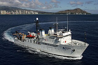
USNS Vindicator (T-AGOS-3) was a United States Navy Stalwart-class modified tactical auxiliary general ocean surveillance ship that was in service from 1984 to 1993. Vindicator then served in the United States Coast Guard from 1994 to 2001 as the medium endurance cutter USCGC Vindicator (WMEC-3). From 2004 to 2020, she was in commission in the National Oceanic and Atmospheric Administration (NOAA) fleet as the oceanographic research ship NOAAS Hiʻialakai.

Sodwana Bay is a bay in South Africa on the KwaZulu Natal north coast, between St. Lucia and Lake Sibhayi. It is in the Sodwana Bay National Park, and the Maputaland Marine Reserve, and is a popular recreational diving destination. The term is commonly used to refer to both the marine reserve and the terrestrial park, as well as the geographical bay.

USS Kittiwake (ASR-13) was a United States Navy Chanticleer-class submarine rescue vessel in commission from 1946 to 1994.
USS YO-257 was a Yard Oiler of the United States Navy that was launched in the early 1940s and scuttled two miles off Waikiki, Honolulu, Hawaii in 1989.
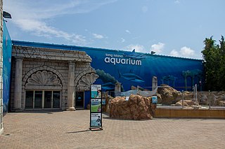
Long Island Aquarium is an aquarium that opened in 2000 on Long Island in Riverhead, New York, United States.

Pisces V is a type of crewed submersible ocean exploration device, powered by battery, and capable of operating to depths of 2,000 metres (6,600 ft), a depth that is optimum for use in the sea waters around the Hawaiian Islands. It is used by scientists to explore the deep sea around the underwater banks in the main Hawaiian Islands, as well as the underwater features and seamounts in the Northwestern Hawaiian Islands, specifically around Kamaʻehuakanaloa Seamount.

Bob Halstead, has made significant contributions to the sport of scuba diving in a multitude of capacities: photographer, author of eight diving books, early innovator in the development of dive tourism, pioneer in the dive liveaboard industry, diving instructor and educator, marine-life explorer and influential diving industry commentator. An ardent diver since 1968, Halstead has over 10,000 logged dives.

Hope Spots are ecologically unique areas of the ocean designated for protection under a global conservation campaign overseen by Mission Blue, a non-profit organization founded by Sylvia Earle with her 2009 TED prize wish.
The following index is provided as an overview of and topical guide to Wikipedia's articles on recreational dive sites. The level of coverage may vary:

Recreational dive sites are specific places that recreational scuba divers go to enjoy the underwater environment or for training purposes. They include technical diving sites beyond the range generally accepted for recreational diving. In this context all diving done for recreational purposes is included. Professional diving tends to be done where the job is, and with the exception of diver training and leading groups of recreational divers, does not generally occur at specific sites chosen for their easy access, pleasant conditions or interesting features.

Underwater diving encompasses a variety of economically and culturally significant forms of diving on the U.S. island territory of Guam. Scuba diving tourism is a significant component of the island's tourist activity, in particular for visitors from Japan and South Korea. Recreational diving by Guam residents has a lesser but still substantial economic impact. Marine biologists have raised concerns about the effect of diving upon the health of some of Guam's reefs. Recreational dive sites on Guam include submerged shipwrecks, such as the double wrecks of SMS Cormoran and Tokai Maru, and natural features, such as Blue Hole.
Piti Bomb Holes Marine Preserve is a marine protected area comprising all of Piti Bay on the western coast of Guam, located off of the village of Piti in the Philippine Sea. The defining "bomb hole" features, named because they look like bomb craters in the reef flat, are actually natural percolation pits where fresh water filters into the shallow lagoon at a depth of 25 to 30 feet. The largest pit houses the commercial Fish Eye Marine Park tourist attraction, which includes a wooden pier to a underwater observatory and a Seawalker tour of the lagoon bottom. It is visited by more than 200,000 people annually. The Piti preserve is the most ecologically diverse of Guam's five marine preserves. The pit around Fish Eye is a popular snorkeling and recreational diving site.

