Related Research Articles

Santa Fe de Nuevo México was a province of the Spanish Empire and New Spain, and later a territory of independent Mexico. The first capital was San Juan de los Caballeros from 1598 until 1610, and from 1610 onward the capital was La Villa Real de la Santa Fe de San Francisco de Asís.

Los Ranchos de Albuquerque, also known simply as "Los Ranchos", is a village in Bernalillo County, New Mexico. The population was 6,024 at the time of the 2010 Census.

The Treaty of Guadalupe Hidalgo officially ended the Mexican–American War (1846–1848). It was signed on 2 February 1848 in the town of Guadalupe Hidalgo.
Pueblo refers to the settlements and to the Native American tribes of the Pueblo peoples in the Southwestern United States, currently in New Mexico, Arizona, and Texas. The permanent communities, including some of the oldest continually occupied settlements in the United States, are called pueblos (lowercased).
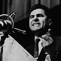
Reies López Tijerina, was an activist who led a struggle in the 1960s and 1970s to restore New Mexican land grants to the descendants of their Spanish colonial and Mexican owners. As a vocal spokesman for the rights of Hispanos and Mexican Americans, he became a major figure of the early Chicano Movement and founded the Alianza Federal de Mercedes. As an activist, he worked in community education and organization, media relations, and land reclamations. He became famous and infamous internationally for his 1967 armed raid on the Tierra Amarilla courthouse located on the Tierra Amarilla Land Grant whose lands, originally designated for Hispanic settlers, had largely been acquired by Anglo ranchers and land developers.

The Mexican Cession is the region in the modern-day western United States that Mexico previously controlled, then ceded to the United States in the Treaty of Guadalupe Hidalgo in 1848 after the Mexican–American War. This region had not been part of the areas east of the Rio Grande that had been claimed by the Republic of Texas, which had been claiming independence since its Texas Revolution of 1836 and subsequent brief war for independence, followed afterwards a decade later by the American annexation and admitted statehood in 1845. It had not specified the southern and western boundary of the new state of Texas with New Mexico consisting of roughly 529,000 square miles (1,370,000 km2), not including any Texas lands, the Mexican Cession was the third-largest acquisition of territory in U.S. history, surpassed only by the 827,000-square-mile (2,140,000 km2) Louisiana Purchase of 1803 and the later 586,000-square-mile (1,520,000 km2) Alaska Purchase from Russia in 1867.

Carson National Forest is a national forest in northern New Mexico, United States. It encompasses 6,070 square kilometers and is administered by the United States Forest Service. The Forest Service's "mixed use" policy allows for its use for recreation, grazing, and resource extraction.
The history of New Mexico is based on archaeological evidence, attesting to the varying cultures of humans occupying the area of New Mexico since approximately 9200 BCE, and written records. The earliest peoples had migrated from northern areas of North America after leaving Siberia via the Bering Land Bridge. Artifacts and architecture demonstrate ancient complex cultures in this region.

Carlos Antonio Carrillo was a Californio politician, military officer, and ranchero. He was nominated to serve as Governor of Alta California from 1837–38, in opposition to Juan Bautista Alvarado's rule. However, after failing to subdue Alvarado, Carrillo relinquished his claim to the governorship to Alvarado in 1838.
The United States Court of Private Land Claims (1891–1904) was an ad-hoc court created to decide land claims guaranteed by the Treaty of Guadalupe Hidalgo, in the territories of New Mexico, Arizona, and Utah, and in the states of Nevada, Colorado, and Wyoming.
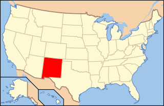
The following is an alphabetical list of articles related to the U.S. state of New Mexico.

The following outline is provided as an overview of and topical guide to the U.S. state of New Mexico:

Rancho Las Vírgenes was a 17,760-acre (71.9 km2) land grant in the Santa Monica Mountains and Simi Hills, in present day western Los Angeles County, California. The lands of the Rancho Las Vírgenes included present day Agoura Hills, Oak Park, and Westlake Village and part of the Santa Monica Mountains.
United States v. Sandoval, 231 U.S. 28 (1913), was a United States Supreme Court case deciding whether the federal government's law prohibiting liquor on the land of Santa Clara Pueblo impermissibly infringed on the State of New Mexico's police power under the equal footing doctrine. In a unanimous decision, the Court upheld the law and Congress's ability to recognize and regulate tribes. Citing broad congressional authority in Kagama, recognition of tribes subject to the guardianship of the federal government falls on Congress, not the Court, as long as recognition is not "arbitrary" and actually reflects "distinctly Indian communities."
Land grants in New Mexico and Colorado were awarded to individuals and communities by the Spanish and Mexican governments to encourage settlement and expansion of the Territorio de Nuevo Mexico, which included southern Colorado. Land grants by the Spanish and Mexicans between 1692 and 1846 numbered 291 in New Mexico, four partly in New Mexico and partly in Colorado, and three in Colorado. The land area of grants totaled tens of thousands of square miles. "The two major types of land grants were private grants made to individuals, and communal grants made to groups of people for the purpose of establishing settlements. Communal land grants were also made to Pueblos for the lands they inhabited." The majority of the land area within grants was designated as common land for residents. Common land was mostly used for grazing cattle and sheep and harvesting timber. Smaller acreages within the grants were devoted to irrigation agriculture and home sites. The principal objectives of the land grants were to encourage the foundation of new communities and to expand the settled area on the frontiers of New Mexico for defense from Indian raids.

The Tierra Amarilla Land Grant in northern New Mexico and southern Colorado consists of 594,516 acres (2,405.92 km2) of mountainous land. The government of New Mexico awarded it to Manuel Martinez and his offspring in 1832. The grant was settled by Hispanics in the 1860s and the original inhabitants, the Ute Indians, were induced to leave. Settlers were given small plots, but most of the land in the grant area was designated as common land for the use of all the settlers and their descendants. After its conquest of New Mexico in 1846, the United States government upheld the validity of the grant, but subsequent actions by the U.S. did not protect the right to access common lands by the settlers. Politician and land speculator Thomas Catron, a member of the Santa Fe Ring, acquired nearly all the land by 1883 but later sold it to a development company. Access to the common lands of the grant by the Hispanic settlers and their descendants gradually disappeared as the common land became owned by Anglo ranchers, development companies, and speculators.
Aboriginal land title in New Mexico is unique among aboriginal title in the United States. Congressional legislation was passed to define such title after the United States acquired this territory following war with Mexico (1846–1848). But the Supreme Court of the New Mexico Territory and the United States Supreme Court held that the Nonintercourse Act did not restrict the alienability of Pueblo lands.
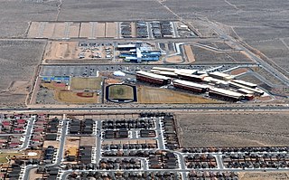
Atrisco Heritage Academy High School (AHAHS), better known as Atrisco Heritage, is a public high school in Albuquerque, New Mexico, United States. It is located on the city’s West Mesa. It is a part of the Albuquerque Public Schools. The school is named after the Atrisco Land Grant. Enrollment at AHAHS was expected to be 2,200 in the fall of 2011.

The San Miguel del Vado Land Grant is one of the Spanish land grants in New Mexico. On November 24, 1794, 53 men submitted a petition for land and were granted temporary possession on November 24, 1794, pending satisfaction of prescribed criteria. A second grant was obtained by 58 men and their respective families on March 12, 1803. Two days later, the procedure was repeated at San José del Vado, 6 kilometres (3.7 mi) north of San Miguel del Vado, distributing farm land to an additional 47 heads of household, including two women.
References
- 1 2 State of New Mexico, Office of the State Historian. "San Miguel del Vado Land Grant". State of New Mexico. Retrieved November 1, 2011.
- ↑ "History of the Atrisco". Petroglyph National Monument . National Park Service. February 17, 2019. Retrieved November 1, 2011.
- 1 2 3 4 Metzcar, Joseph V. (October 1, 1977). "Atrisco Land Grant, 1692–1977". New Mexico Historical Review. 52 (4). Albuquerque: University of New Mexico: 269. ProQuest 1301802258. Archived from the original on April 6, 2012.
- 1 2 "Land Grants". Albuquerque Historical Society. Retrieved November 1, 2011.
- ↑ Mexicanos: A History of Mexicans in the United States, Manuel G. Gonzales, Indiana University Press, P.86-87 ISBN 0-253-33520-5
- ↑ The U.S.-Mexico Border: The Treaty of Guadalupe Hidalgo, John C. Davenport, P.48, ISBN 0-7910-7833-7
- ↑ "no claimant could secure such legislative confirmation of his title unless he had money enough to go to Washington, organize a lobby, fight or buy off bloodsuckers and wield sufficient influence to get a bill through Congress for such purposes." Stone, W.F. (1904) "The United States Court of Private Land Claims," New Mexico Bar Association Minutes of the Annual Meeting p. 7
- ↑ Reeve, Frank D. (1961) History of New Mexico Lewis Historical Publishing Co., New York, vol. 2, p.255
- ↑ Commission of Public Records, State Records Center and Archives. "Land Grants". State of New Mexico. Archived from the original on November 28, 2011. Retrieved November 1, 2011.
- ↑ Case of James M. Hubbell v. Town of Atrisco, October 2, 1935; & Report of J. G. Whitehouse, February 7, 1936; from Metzcar, Joseph V. "Atrisco Land Grant, 1692–1977". New Mexico State Record Center and Archives. Archived from the original on April 6, 2012. Retrieved November 1, 2011.
- ↑ Jack, Hartsfield. "Westland Development Company's billion dollar nest egg – Atrisco Land Grant – includes article: Atrisco: a trip back 300 years". CBS Interactive. Retrieved November 1, 2011.