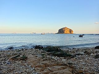
Atuona Bay (FrenchBaie d'Atuona or Baie Tahauku) is a small inlet on the north shore of Ta‘a ‘Oa (the Bay of Traitors), on the southern coast of Hiva ‘Oa. The bay is traditionally called Vevau in Marquesan.
French is a Romance language of the Indo-European family. It descended from the Vulgar Latin of the Roman Empire, as did all Romance languages. French evolved from Gallo-Romance, the spoken Latin in Gaul, and more specifically in Northern Gaul. Its closest relatives are the other langues d'oïl—languages historically spoken in northern France and in southern Belgium, which French (Francien) has largely supplanted. French was also influenced by native Celtic languages of Northern Roman Gaul like Gallia Belgica and by the (Germanic) Frankish language of the post-Roman Frankish invaders. Today, owing to France's past overseas expansion, there are numerous French-based creole languages, most notably Haitian Creole. A French-speaking person or nation may be referred to as Francophone in both English and French.
Ta‘a ‘Oa is the South Marquesan name of a wide bay on the southern coast of Hiva ‘Oa in French Polynesia. The bay is widely known in English as the Bay of Traitors, and in French as Baie des Traitres.
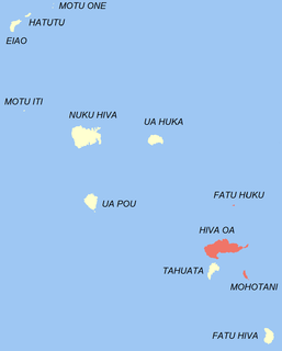
With its 320 square kilometres, Hiva Oa is the second largest island in the Marquesas Islands, in French Polynesia, an overseas territory of France in the Pacific Ocean. Located at 9 45' south latitude and 139 W longitude, it is the largest island of the southern Marquesas group. Around 2,200 people reside on the island. A volcano, Temetiu, is Hiva Oa's highest point with 1,200 metres.
Atuona, located on Atuona Bay on the southern side of Hiva Oa island, French Polynesia, is the administrative centre of the commune (municipality) of Hiva-Oa. Atuona was the capital of all the Marquesas Islands but it has been replaced by Taiohae.
The Marquesas Islands are a group of volcanic islands in French Polynesia, an overseas collectivity of France in the southern Pacific Ocean. The Marquesas are located at 9.7812° S, 139.0817° W. The highest point is the peak of Mount Oave on Ua Pou island at 1,230 m (4,035 ft) above sea level.
Atuona Bay is separated from the excellent harbor of Taha Uku to its east, by a headland called Feki, and from westernmore extensions of Ta'a Oa by a small rock called Hanakee.
A harbor or harbour is a sheltered body of water where ships, boats, and barges can be docked. The term harbor is often used interchangeably with port, which is a man-made facility built for loading and unloading vessels and dropping off and picking up passengers. Ports usually include one or more harbors. Alexandria Port in Egypt is an example of a port with two harbors.
Taha Uku is a small bay on the north shore of Ta‘a ‘Oa on the southern coast of Hiva ‘Oa.
A geographic coordinate system is a coordinate system that enables every location on Earth to be specified by a set of numbers, letters or symbols. The coordinates are often chosen such that one of the numbers represents a vertical position and two or three of the numbers represent a horizontal position; alternatively, a geographic position may be expressed in a combined three-dimensional Cartesian vector. A common choice of coordinates is latitude, longitude and elevation. To specify a location on a plane requires a map projection.
This page is based on this Wikipedia article Text is available under the CC BY-SA 4.0 license; additional terms may apply. Images, videos and audio are available under their respective licenses.
Related Research Articles
Green Bay is an arm of Lake Michigan, located along the south coast of Michigan's Upper Peninsula and the east coast of Wisconsin. It is separated from the rest of the lake by the Door Peninsula in Wisconsin, the Garden Peninsula in Michigan, and the chain of islands between them, all formed by the Niagara Escarpment. Green Bay is some 120 miles (193 km) long, with a width ranging from about 10 miles (16 km) to 20 mi (32 km). It is 1,626 square miles (4,210 km2) in area.
Fatu Hiva is the southernmost island of the Marquesas Islands, in French Polynesia, an overseas territory of France in the Pacific Ocean. With Motu Nao as its closest neighbor, it is also the most isolated of the inhabited islands.
Yakutat Bay is a 29-km-wide (18 mi) bay in the U.S. state of Alaska, extending southwest from Disenchantment Bay to the Gulf of Alaska. "Yakutat" is a Tlingit name reported as "Jacootat" and "Yacootat" by Yuri Lisianski in 1805.
Rapa, sometimes called Rapa Iti, is the largest and only inhabited island of the Bass Islands in French Polynesia. An older name for the island is Oparo. Its area is 40 km2 with a population of almost 500 and a max elevation of 650 m. Its main town is Ahuréi.
The Paul Gauguin Cultural Center was finished in 2003, to coincide with the 100th anniversary of the death of Paul Gauguin, in Atuona, on Hiva ‘Oa, in the Marquesas Islands.
Temetiu is the South Marquesan name for the highest peak of the mountain ridge that rises above the western end of Ta'a Oa in southwestern Hiva ‘Oa.
Calvary Cemetery is the main cemetery in Atuona, Hiva ‘Oa, French Polynesia. It is located on a hillside on the eastern edge of town, overlooking the anchorage on Atuona Bay.
Ha‘ava is the Marquesan name of the 4 km (2.5 mi.) wide channel that separates Tahuata from Hiva Oa, in the southern Marquesas Islands. The French name for the passage is Canal du Bordelais.
Hanakee is the name of a small rocky islet lying off the southern coast of Hiva Oa, separating Atuona Bay from Ta‘a Oa.
Hana Vave is the name of the northernmost bay on the west coast of Fatu Hiva. The bay is sometimes called the Bay of Virgins, a translation of the French name Baie des Vierges.
Thunder Bay is a large bay on the northern shore of Lake Superior, in Thunder Bay District, Ontario, Canada. The bay is about 50 kilometres (31 mi) long and 22 kilometres (14 mi) wide. It is bordered to the east by the Sibley Peninsula at the southern tip of which is Thunder Cape, marking the entrance to the bay for ships approaching from the east. The mesas and sills on the peninsula are known as the Sleeping Giant due to their appearance when viewed from Thunder Bay.
Pointe-Noire Bay is a small bay in the Republic of the Congo, at 4.7433333°S 11.8252778°E. The city of Pointe-Noire lies at the southern end of the bay.
Atuona Airport or Hiva Oa Airport is an airport located 4.5 kilometres (2.8 mi) northeast of Atuona, on the island of Hiva Oa, in the Marquesas Islands of French Polynesia.
Hiva-Oa is a commune of French Polynesia, an overseas territory of France in the Pacific Ocean. The commune is in the administrative subdivision of the Marquesas Islands.
This page list topics related to French Polynesia.