
Bhilangna River is a Himalayan river in Uttarakhand, India, which is the major tributary of the Bhagirathi river, the source stream of the Ganges River of India. Bhilangana is a combination of Bhil and Ganga.

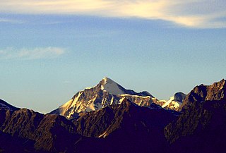
Nilkantha is a major peak of the Garhwal division of the Himalayas, in the Uttarakhand region of the Indian state of Uttarakhand. Although substantially lower than the highest peaks of the region, it towers dramatically over the valley of the Alaknanda River and rises 3,474 metres (11,398 ft) above the Hindu pilgrimage site of Badrinath, only 9 km (6 mi) to the east. Frank Smythe described the peak as "second only to Siniolchu in Himalayan beauty."
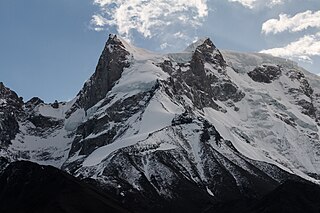
Swargarohini is a mountain massif in the Saraswati (Bandarpunch) Range of the Garhwal Himalaya. It lies in the Uttarkashi District of the northern Indian state of Uttarakhand, west of the Gangotri group of peaks. It comprises four separate peaks, the main peak Swargarohini I is the subject of this article.

Kalindi pass, or Kalindi khal is a high altitude mountain pass connecting Gangotri and Ghastoli. It is situated at 5,942 metres (19,495 ft) elevation and is arguably the most famous trekking pass of the Garhwal Himalaya. The pass is heavily glaciated. The glacier west of the pass flows into the Gangotri Glacier which forms the source of the Ganges.

Bhagirathi Massif or Bhagirathi Group is a mountain range of Garhwal Himalaya in Gangotri Glacier Uttarakhand India, It has four peaks between 6856 meter and 6193 meter. The Bhagirathi I summits is 6856 meter or 22493 feet. It was first climbed by A Japanese team in 1980. It is surrounded by Glaciers on four side on the eastern side of the Massif is Vasuki Glacier, on the western side its Gangotri Glacier the main glacier in this area, northern side is surrounded by Chaturangi Glacier and southern side guarded by Swachhhand Glacier.
Mana Parbat III is a mountain of the Garhwal Himalaya in Uttarakhand, India. Mana Parbat III standing majestically at 6,730 metres (22,080 ft). It is 43rd highest located entirely within the Uttrakhand. Nanda Devi, is the highest mountain in this category. It is located 2.1 km ESE of Mana Parbat I 6,771 metres (22,215 ft) and 1.4 km north west lies Pilapani Parbat 6,796 metres (22,297 ft). On the south side lies the Chandra Parbat I 6,739 metres (22,110 ft) and Bhgirathi Massif on the south west side.
Chaturbhuj is a mountain of the Garhwal Himalaya in Uttarakhand, India. The elevation of Chaturbhuj is 6,654 metres (21,831 ft) and its prominence is 357 metres (1,171 ft). It is 52nd highest located entirely within the Uttrakhand. Nanda Devi, is the highest mountain in this category. Chaturbhuj lies between the Matri 6,721 metres (22,051 ft) and Shwetvarn 6,340 metres (20,801 ft). Its nearest higher neighbor Yogeshwar lies 2.7 km east. It is located 5.9 km NW of chirbas Parbat 6,529 metres (21,421 ft) and 8.5 km east lies Sri Kailash 6,932 metres (22,743 ft).
Kirti Stambh is a mountain of the Garhwal Himalaya in Uttarakhand India.The elevation of Kirti Stambh is 6,270 metres (20,571 ft) and its prominence is 100 metres (328 ft). It is 128th highest located entirely within the Uttrakhand. Nanda Devi, is the highest mountain in this category. It lies between Thalaysagar and Bhartekunta. Its nearest higher neighbor Bhartekunta 6,578 metres (21,581 ft) lies 2.3 km SE. It is located 5.1 km SSE of Thalaysagar 6,904 metres (22,651 ft) and 12.8 km NEE lies Bhagirathi I 6,856 metres (22,493 ft).

Bhartekunta is a mountain of the Garhwal Himalaya in Uttarakhand India.The elevation of Bhartekunta is 6,578 metres (21,581 ft) and its prominence is 280 metres (919 ft). It is 69th highest located entirely within the Uttrakhand. Nanda Devi, is the highest mountain in this category. It lies between Kirti Stambh and Kedarnath (mountain). Its nearest higher neighbor Kedarnath (mountain) 6,940 metres (22,769 ft) lies 3 km ESE. It is located 2.3 km SE of Kirti Stambh 6,279 metres (20,600 ft) and 6.9 km north lies Meru Peak 6,660 metres (21,850 ft).
Satopanth South West also called P. 6770 is a mountain of the Garhwal Himalaya in Uttarakhand, India. The elevation of Satopanth south west is 6,770 metres (22,211 ft) and its prominence is 195 metres (640 ft). It is 40th highest located entirely within the Uttrakhand. Nanda Devi, is the highest mountain in this category. It lies in the same connecting ridge that joins Satopanth and Bhagirathi Parbat I. It lies 1.8 km SW of Satopanth. Its nearest higher neighbor Satopanth 7,075 metres (23,212 ft). It is located 3.4 km SE of Vasuki South 6,702 metres (21,988 ft) and 5.2 km NNW lies Bhagirathi I 6,856 metres (22,493 ft).
Jogin I is a mountain of the Garhwal Himalaya in Uttarakhand India.The elevation of Jogin I is 6,465 metres (21,211 ft) and its prominence is 843 metres (2,766 ft). It is 94th highest located entirely within the Uttrakhand. Nanda Devi, is the highest mountain in this category. It lies 5.4 km east of Gangotri III and 7.4 km west of Bhrigupanth 6,772 metres (22,218 ft). It lies 2.2 km South of Jogin II. Its nearest higher neighbor is Gangotri III 6,577 metres (21,578 ft). It is located 6.9 km NW of Thalaysagar 6,904 metres (22,651 ft) and 8.8 km NW lies Gangotri I 6,682 metres (21,923 ft).
Jogin II is a mountain of the Garhwal Himalaya in Uttarakhand India.The elevation of Jogin II is 6,342 metres (20,807 ft) and its prominence is 259 metres (850 ft). It is 110th highest located entirely within the Uttrakhand. Nanda Devi, is the highest mountain in this category. It lies 6.2 km east of Gangotri III and 7 km west of Bhrigupanth 6,772 metres (22,218 ft). It lies 2.2 km north of Jogin I. Its nearest higher neighbor is Jogin I 6,465 metres (21,211 ft). It is located 7.2 km NW of Thalay Sagar 6,904 metres (22,651 ft) and 8.5 km NW lies Gangotri I 6,682 metres (21,923 ft).
Jogin III is a mountain of the Garhwal Himalaya in Uttarakhand, India. The elevation of Jogin III is 6,116 metres (20,066 ft). It is 155th highest located entirely within the Uttrakhand. Nanda Devi, is the highest mountain in this category.

Manda I is a mountain of the Garhwal Himalaya in Uttarakhand India also called Manda. The elevation of Manda I is 6,510 metres (21,358 ft) and its prominence is 226 metres (741 ft). It is joint 86th highest located entirely within the Uttarakhand. Nanda Devi, is the highest mountain in this category. It lies 1.6 km (0.99 mi) north of Manda II 6,568 metres (21,549 ft) and 3.9 km (2.4 mi) north of Manda III 6,529 metres (21,421 ft). It lies 7.8 km (4.8 mi) NE of Jogin II 6,342 metres (20,807 ft). It is located 6.6 km (4.1 mi) north of Bhrigupanth 6,772 metres (22,218 ft) and 9.6 km (6.0 mi) SW lies Jogin I 6,465 metres (21,211 ft).
Shwetvarna is a mountain of the Garhwal Himalaya in Uttarakhand India.The elevation of Shwetvarna is 6,340 metres (20,801 ft) and its prominence is 240 metres (787 ft). It is 111th joint highest located entirely within the Uttrakhand. Nanda Devi, is the highest mountain in this category. It lies 1.2 km SSE of Chaturbhuj 6,654 metres (21,831 ft) its nearest higher neighbor and it is 1.2 km SSW of Sudarshan Parbat 6,507 metres (21,348 ft). It lies 3 km NW of Shyamvarn 6,135 metres (20,128 ft).
Deo Damla is a mountain of the Garhwal Himalaya in Uttarakhand, India. It is situated in the eastern rim of Nanda Devi Sanctuary on the watershed of Milam Glacier and Nanda Devi basin. The elevation of Deo Damla is 6,620 metres (21,719 ft) and its prominence is 693 metres (2,274 ft). It is 63rd highest located entirely within the Uttrakhand. Nanda Devi, is the highest mountain in this category. It lies 1.8 km SSE of Mangraon 6,568 metres (21,549 ft). Its nearest higher neighbor Rishi Pahar 6,992 metres (22,940 ft) lies 8.3 km NNW and it is 10.6 km SSW of Nanda Devi 7,816 metres (25,643 ft). It lies 1.4 km north of Bamchu 6,303 metres (20,679 ft).
Srikantha is a mountain of the Garhwal Himalaya in Uttarakhand India. The elevation of Srikantha is 6,133 metres (20,121 ft) and its prominence is 471 metres (1,545 ft). It is 151st highest located entirely within the Uttrakhand. Nanda Devi, is the highest mountain in this category. It lies 5.8 km NW of Gangotri I 6,672 metres (21,890 ft). Jaonli 6,632 metres (21,759 ft) lies 12.3 km SSE and it is 18.6 km west of Manda I 6,510 metres (21,358 ft). It lies 14.4 km NW of Jogin I 6,465 metres (21,211 ft).
Saife is a mountain of the Garhwal Himalaya in the Indian state of Uttarakhand.
Shyamvarn is a mountain of the Garhwal Himalaya in Uttarakhand India. The peak lies above the Shyamvarn Glacier. The elevation of Shyamvarn is 6,135 metres (20,128 ft) and its prominence is 250 metres (820 ft). It is 150th highest located entirely within the Uttrakhand. Nanda Devi, is the highest mountain in this category. It lies 3.3 km east of Sudarshan Parbat 6,507 metres (21,348 ft). Saife 6,161 metres (20,213 ft) lies 2.5 km WSW and it is 3 km ESE of Shwetvarna 6,340 metres (20,801 ft). It lies 2.8 km South of Yogeshwar 6,678 metres (21,909 ft).
