Main-Kinzig-Kreis is a Kreis (district) in the east of Hesse, Germany. Neighboring districts are Wetteraukreis, Vogelsbergkreis, Fulda, Bad Kissingen, Main-Spessart, Aschaffenburg, Offenbach and the district-free cities of Offenbach and Frankfurt.

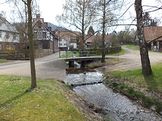
The Kinzig is a river, 87 kilometres long, in southern Hesse, Germany. It is a right tributary of the Main. Its source is in the Spessart hills at Sterbfritz, near Schlüchtern. The Kinzig flows into the Main in Hanau. The Main-Kinzig-Kreis (district) was named after the river. The towns along the Kinzig are Schlüchtern, Steinau an der Straße, Bad Soden-Salmünster, Gelnhausen, and Hanau. The Kinzig is first recorded in 815 A.D. as Chinzicha.

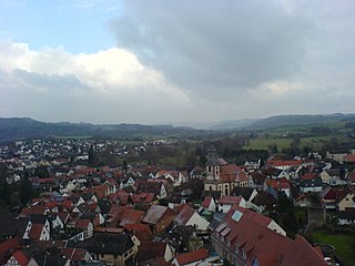
Schlüchtern is a town in the Main-Kinzig district, in Hessen, Germany. It is located on the river Kinzig, approximately 30 km southwest of Fulda. Schlüchtern has a population close to 16,000.
Steinau an der Straße is a town of around 10,000 inhabitants in the Main-Kinzig district, in Hesse, Germany. It is situated on the river Kinzig, 32 kilometres (20 mi) southwest of Fulda. The name Steinau refers to stones in the river; an der Straße, meaning on the road, refers to the historic trade route Via Regia from Leipzig to Frankfurt on which it was located. Steinau is best known for the Brothers Grimm who spent part of their childhood here.

Flieden is a municipality in the district of Fulda, in Hesse, Germany. Traditionally called a “Königreich” (Kingdom), it may show a crown in its coat of arms.

Sinntal is a municipality in the Main-Kinzig district, in Hesse, Germany. It has a population of around 8,800.

The Flieden–Gemünden railway is a double track electrified railway line from Fulda, Flieden and Schlüchtern via Jossa to Gemünden am Main. The northern part of the line is in the German state of Hesse and it crosses into Bavaria south of Jossa.

Petrus Lotichius Secundus or Peter Lotz was a scholar and a significant Neo-Latin poet of the 16th century.

Elmbach is a river of Hesse, Germany. It flows into the Kinzig in Schlüchtern.

Grennelbach is a small river of Hesse, Germany. It flows into the Kinzig near Schlüchtern-Vollmerz.
The Grom-Bach is a small river of Hesse, Germany.
The Hohensteinerbach is an almost 6.5 km long left and south-eastern tributary of the Nidda in the Wetterau region of Hesse.
Ramholzer Wasser is a small river of Hesse, Germany. It flows into the Kinzig east of Schlüchtern.

Riedbach is a small river of Hesse, Germany. It flows into the Kinzig in Schlüchtern.

Flieden station is a station in the town of Flieden in the German state of Hesse, where the Flieden–Gemünden railway branches off the Frankfurt–Göttingen railway. The station is classified by Deutsche Bahn (DB) as a category 5 station.
East Hesse is a common but not unofficial regional name for the eastern part of the German state of Hesse as well as a regional planning region. It corresponds roughly to the Hessian catchment area of Fulda and its heart covers the county of Fulda, the eastern part of the county of Vogelsbergkreis and the old counties of Hersfeld and Schlüchtern, but there is no clear boundary of East Hesse with North Hesse, Middle Hesse and South Hesse. In older sources, a landscape, roughly identical with the current East Hesse area, was commonly called Buchonia.

The Eselsweg is a long-distance hiking trail that follows an ancient trade route through the Mittelgebirge Spessart, in the states of Hesse and Bavaria, Germany. It is 111 km long and leads from Schlüchtern in the valley of the Kinzig river to Großheubach on the river Main. The trail follows an ancient trade route on which donkey caravans used to transport salt, thus giving rise to the name.

Fulda is an electoral constituency represented in the Bundestag. It elects one member via first-past-the-post voting. Under the current constituency numbering system, it is designated as constituency 173. It is located in eastern Hesse, comprising the Fulda district and the southeastern part of the Vogelsbergkreis district.

