
The Yellowstone River is a tributary of the Missouri River, approximately 692 miles (1,114 km) long, in the western United States. Considered the principal tributary of the upper Missouri, this river, via its tributaries, drains a wide area, stretching from the Rocky Mountains in the vicinity of Yellowstone National Park, across the mountains and high plains of southern Montana and northern Wyoming.

The Madison River is a headwater tributary of the Missouri River, approximately 183 miles (295 km) long, in Wyoming and Montana. Its confluence with the Jefferson and Gallatin rivers near Three Forks, Montana forms the Missouri River.

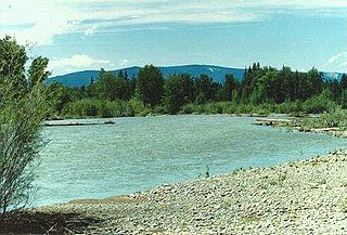
The Big Hole River is a tributary of the Jefferson River, approximately 153 miles (246 km) long, in Beaverhead County, in southwestern Montana, United States. It is the last habitat in the contiguous United States for native fluvial Arctic grayling and is a historically popular destination for fly fishing, especially for trout.

Periphyton is a complex mixture of algae, cyanobacteria, heterotrophic microbes, and detritus that is attached to submerged surfaces in most aquatic ecosystems. The related term Aufwuchs refers to the collection of small animals and plants that adhere to open surfaces in aquatic environments, such as parts of rooted plants. Periphyton serves as an important food source for invertebrates, tadpoles, and some fish. It can also absorb contaminants, removing them from the water column and limiting their movement through the environment. The periphyton is also an important indicator of water quality; responses of this community to pollutants can be measured at a variety of scales representing physiological to community-level changes. Periphyton has often been used as an experimental system in, e.g., pollution-induced community tolerance studies.

Absaroka–Beartooth Wilderness was created from existing National Forest lands in 1978 and is located in Montana and Wyoming, United States. The wilderness is partly in Gallatin, Custer and Shoshone National Forests and is composed of 944,000 acres (3,820 km2). The wilderness encompasses two distinct mountain ranges, namely the Beartooth and Absaroka ranges. These ranges are completely distinct geologically speaking with the Absarokas composed primarily of volcanic and metamorphic rock, while the Beartooths are made up almost entirely of granitic rocks. The Absarokas are noted for their dark and craggy appearance, lush and heavily forested valleys and abundant wildlife. The highest peak in the range, located in Wyoming, is Francs Peak at 13,153 feet (4,009 m). The Beartooths are more alpine with huge treeless plateaus and the highest peak in the state of Montana. The wilderness contains 30 peaks over 12,000 feet (3,700 m). The wilderness is an integral part of the 20-million-acre (81,000 km2) Greater Yellowstone Ecosystem and borders Yellowstone National Park.

Spring Meadow Lake State Park is a public recreation area covering 61 acres (25 ha) just west of Helena, Montana. Once the site of a gravel pit and factory, the state park centers around a man-made, spring-fed lake, which is used for swimming, fishing, non-motorized boating, and scuba diving. The park also offers picnicking, a mile-long trail around the lake, and ice fishing and ice skating in winter. Largemouth bass, westslope cutthroat trout, yellow perch, and pumpkinseed are the main catches. A fishing pier was added to 30-acre (12 ha) lake in 2011.
The Blackfoot River, sometimes called the Big Blackfoot River to distinguish it from the Little Blackfoot River, is a snow-fed and spring-fed river in western Montana. The Blackfoot River begins in Lewis and Clark County at the Continental Divide, 10 miles (16 km) northeast of the town of Lincoln. The river's headwaters are between Rogers Pass to the north and Stemple Pass to the south. It flows westward through the town of Milltown and enters the Clark Fork River approximately five miles (8 km) east of the city of Missoula.
Lake Sherburne is located in the Many Glacier region of Glacier National Park, in the U.S. state of Montana. The lake is a reservoir, formed by Lake Sherburne Dam, which impounded Swiftcurrent Creek and was constructed in between 1914 and 1921. The construction of the dam inundated several small lakes and highly productive riparian and wetland areas, and due to its fluctuating water levels, the surrounding area supports little vegetation. However, trumpeter swans are often observed along the lake in the spring and fall. The lake stretches nearly 6 miles (9.7 km) when full. The reservoir is the principal water storage component of the U.S. Bureau of Reclamation's Milk River Project, which provides irrigation water to north central Montana farms.
The Mackinaw boat is a loose, non-standardized term for a light, open sailboat used in the interior of North America during the fur trading era. Within this term two different Mackinaw boats evolved: one for use on the upper Great Lakes, and the other for use on the upper Missouri River and its principal tributaries.
The Flathead Valley, located in Northwestern Montana, is a region of the U.S. state of Montana. It includes Flathead County, and part of Lake County. Notable towns include Bigfork, Kalispell, Columbia Falls, Polson, and Whitefish. The geography of the Flathead roughly corresponds to the valley where Flathead Lake is located. In addition to the lake, the area's proximity to attractions such as Glacier National Park and Whitefish Mountain Resort have made the area a major resort destination. Many outdoor activities can be pursued there such as hiking, backpacking, rafting, canoeing, skiing, hunting, and trout fishing. The Flathead Valley is also home to a portion of the Flathead Indian Reservation.
Lost Coon Lake, is a lake south of Whitefish, Flathead County in the state of Montana, USA. This lake was once known to be home to a variety of fish and can be fished by fly rod or baitcasting. Alternate names for this lake include Lost Loon Lake.

Lake Elmo State Park is a public recreation area located on the northeast side of Billings, Montana. The state park occupies 123 acres (50 ha) and is at an elevation of 3,199 feet (975 m). It offers non-motorized boating on a 64-acre (26 ha) reservoir, three beach-front areas, fishing pier, grassed multi-use areas, two group-use shelters, playground, and fenced-in dog park on the lake's west side.

Whitefish Lake State Park is a 10-acre (4.0 ha) public recreation area on Whitefish Lake located off U.S. Highway 93 two miles northwest of Whitefish, Montana. The state park offers opportunities boating, swimming, tent and RV camping, and fishing. Sites for hike-in/bike-in camping were added in 2016.
Ackley Lake State Park is a public recreation area located four miles southwest of Hobson, Montana. The state park covers 290 acres (120 ha) centered around 160-acre (65 ha) Ackley Lake. The Little Belt Mountains and Snowy Mountains are visible on the horizon. The park is operated by the Montana Department of Fish, Wildlife and Parks on land leased from the Montana Department of Natural Resources and Conservation.
Big Arm State Park is a Montana state park that is a unit of Flathead Lake State Park near Big Arm, Montana. Big Arm State Park is located on the western shores of Flathead Lake, the largest natural freshwater lake in the western United States. The park's recreational activities include fishing, boating, RV and tent camping, and swimming.

Placid Lake State Park is a public recreation area located 28 miles (45 km) northeast of Missoula, Montana. The state park sits on 31 acres (13 ha) at the eastern end of Placid Lake that include the lake's outlet to Owl Creek, a tributary of the Clearwater River. The park is known for its scenery, camping, aquatic recreation, and fishing.

West Shore State Park is a public recreation area occupying 129 acres on the western shore of Flathead Lake five miles south of Lakeside in Lake County, Montana. The state park offers boating, fishing, camping, swimming, hiking, and wildlife viewing.

Hell Creek State Park is a public recreation area on the south side of Fort Peck Lake located twenty miles (32 km) due north of the community of Jordan, Montana. The state park's 337 acres (136 ha) sit on the western side of Hell Creek Bay and include a year-round marina, facilities for water sports, camping, and fishing for walleye, northern pike, smallmouth bass, and spring lake trout.
Logan State Park is a public recreation area on the north shore of Middle Thompson Lake, off US Route 2 midway between Libby and Kalispell, Montana. The state park encompasses 17 acres (6.9 ha) within 3,000-acre Thompson Chain of Lakes State Park. It offers swimming, boating, fishing, and camping.

Yellow Bay State Park is a public recreation area occupying fifteen acres (6.1 ha) on the eastern shore of Flathead Lake twelve miles (19 km) south of Bigfork in Lake County, Montana. The state park offers boating, fishing, camping, swimming, and wildlife viewing.
