The Modified Mercalli intensity scale, developed from Giuseppe Mercalli's Mercalli intensity scale of 1902, is a seismic intensity scale used for measuring the intensity of shaking produced by an earthquake. It measures the effects of an earthquake at a given location, distinguished from the earthquake's inherent force or strength as measured by seismic magnitude scales. While shaking is caused by the seismic energy released by an earthquake, earthquakes differ in how much of their energy is radiated as seismic waves. Deeper earthquakes also have less interaction with the surface, and their energy is spread out across a larger volume. Shaking intensity is localized, generally diminishing with distance from the earthquake's epicenter, but can be amplified in sedimentary basins and certain kinds of unconsolidated soils.

Charles Francis Richter was an American seismologist and physicist.

Beno Gutenberg was a German-American seismologist who made several important contributions to the science. He was a colleague and mentor of Charles Francis Richter at the California Institute of Technology and Richter's collaborator in developing the Richter magnitude scale for measuring an earthquake's magnitude.

Giuseppe Mercalli was an Italian volcanologist and Catholic priest. He is known best for the Mercalli intensity scale for measuring earthquake intensity.
The Medvedev–Sponheuer–Karnik scale, also known as the MSK or MSK-64, is a macroseismic intensity scale used to evaluate the severity of ground shaking on the basis of observed effects in an area where an earthquake transpires.
The 1918 San Fermín earthquake, also known as the Puerto Rico earthquake of 1918, struck the island of Puerto Rico at on October 11. The earthquake measured 7.1 on the moment magnitude scale and IX (Violent) on the Mercalli intensity scale. The mainshock epicenter occurred off the northwestern coast of the island, somewhere along the Puerto Rico Trench.

The 1857 Basilicata earthquake occurred on December 16 in the Basilicata region of Italy southeast of the city of Naples. The epicentre was in Montemurro, on the western border of the modern province of Potenza. Several towns were destroyed, and there were around 11,000 fatalities according to official sources, but unofficial estimates suggest that as many as 19,000 died. At the time it was the third-largest known earthquake and has been estimated to have been of magnitude 7.0 on the moment magnitude scale.
The Dasht-e Bayaz and Ferdows earthquakes occurred in Dashte Bayaz, Kakhk and Ferdows, Iran in late August and early September 1968. The mainshock measured 7.4 on the moment magnitude scale and had a maximum perceived intensity of X (Extreme) on the Mercalli intensity scale. Damage was heavy in the affected areas with thousands of lives lost in the first event and many hundreds more in the second strong event.
The 1202 Syria earthquake struck at about dawn on 20 May 1202 with an epicenter in southwestern Syria. The earthquake is estimated to have killed around 30,000 people. It was felt over a very wide area, from Sicily to Mesopotamia and Anatolia to upper Egypt, mostly affecting the Ayyubid Sultanate and the Kingdom of Jerusalem. The cities of Tyre, Acre and Nablus were heavily damaged. A magnitude of 7.6 has been estimated with damage up to XI on the Mercalli intensity scale.

The Galilee earthquake of 1837, often called the Safed earthquake, shook the Galilee on January 1 and is one of a number of moderate to large events that have occurred along the Dead Sea Transform (DST) fault system that marks the boundary of two tectonic plates; the African Plate on the west and the Arabian Plate on the east. Intensity assessments for the event were VIII (Damaging) on the Medvedev–Sponheuer–Karnik scale and VIII on the European Macroseismic Scale.

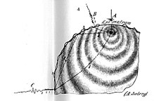
In seismology, an isoseismal map is used to show lines of equally felt seismic intensity, generally measured on the Modified Mercalli scale. Such maps help to identify earthquake epicenters, particularly where no instrumental records exist, such as for historical earthquakes. They also contain important information on ground conditions at particular locations, the underlying geology, radiation pattern of the seismic waves, and the response of different types of buildings. They form an important part of the macroseismic approach, i.e. that part of seismology dealing with noninstrumental data. The shape and size of the isoseismal regions can be used to help determine the magnitude, focal depth, and focal mechanism of an earthquake.
Harry Oscar Wood (1879–1958) was an American seismologist who made several significant contributions in the field of seismology in the early twentieth-century. Following the 1906 earthquake in San Francisco, California, Wood expanded his background of geology and mineralogy and his career took a change of direction into the field of seismology. In the 1920s he co-developed the torsion seismometer, a device tuned to detect short-period seismic waves that are associated with local earthquakes. In 1931 Wood, along with another seismologist, redeveloped and updated the Mercalli intensity scale, a seismic intensity scale that is still in use as a primary means of rating an earthquake's effects.
Nicholas Neocles Ambraseys FICE FREng was a Greek engineering seismologist. He was emeritus professor of engineering seismology and senior research fellow at Imperial College London. For many years Ambraseys was considered the leading figure and an authority in earthquake engineering and seismology in Europe.
The 1941 Gloria Fault earthquake occurred at 18:03:57 UTC in the northern Atlantic Ocean on 25 November 1941. It had a magnitude of about 8.0 on the moment magnitude scale and a maximum perceived intensity of IX (Violent) on the Mercalli intensity scale. It was caused by movement on the Gloria Fault, part of the Azores–Gibraltar Transform Fault. It triggered a small tsunami, which was observed at Newlyn, Cornwall.
Seismic intensity scales categorize the intensity or severity of ground shaking (quaking) at a given location, such as resulting from an earthquake. They are distinguished from seismic magnitude scales, which measure the magnitude or overall strength of an earthquake, which may, or perhaps may not, cause perceptible shaking.
The 1790 Oran earthquake occurred on October 10, striking near the coastal city of Oran in Algeria. The earthquake had an evaluated maximum seismic intensity of VIII–X on the European macroseismic scale (EMS-98). An estimated 3,000 people died during the earthquake and accompanying tsunami. The magnitude of this earthquake has been disputed among members of the paleoseismology field, with estimates ranging from 7.5 to even as small as 5.5.
The northern part of the Ottoman Empire was struck by a major earthquake on 13 August 1822. It had an estimated magnitude of 7.0 and a maximum felt intensity of IX (Destructive) on the European macroseismic scale (EMS). It may have triggered a tsunami, affecting nearby coasts. Damaging aftershocks continued for more than two years, with the most destructive being on 5 September 1822. The earthquake was felt over a large area including Rhodes, Cyprus and Gaza. The total death toll reported for this whole earthquake sequence ranges between 30,000 and 60,000, although 20,000 is regarded as a more likely number.
The 1858 Prome earthquake occurred on August 24 at 15:38 local time in British Burma. The earthquake occurred with a magnitude of 7.6–8.3 on the moment magnitude scale. It had an epicenter in near the city of Pyay (Prome), Bago. The shock was felt with a maximum Modified Mercalli intensity of XI (Extreme) for about one minute. Severe damage was reported in Bago, and off the coast of Rakhine, an island sunk.
On 14 February 1927 at 03:43 UTC, a strong earthquake shook Bosnia and Herzegovina. Damage occurred in Eastern Herzegovina; Ljubinje was the worst affected town. Serious damage and injuries were also reported in the town of Stolac, while deaths occurred in the village of Berkovići. This may be the strongest known earthquake in Eastern Herzegovina.