Augustin Royer was a French architect[1][2] who lived in the time of Louis XIV.
In 1679 he published a star map; in addition to the 48 constellations of Ptolemy, and the additions of more recent astronomers such as Plancius, he added two constellations of his own, in honour of his patron, Louis XIV; Lilium (the Lily, representing the emblem of France) and Sceptrum et Manus Iustitiae (the Sceptre and the Hand of Justice, depicting the regal symbols).
Neither of these constellations has survived in the modern system.
Royer is often named as the creator of the constellation Columba (the Dove) by splitting off part of the constellation Canis Major, and the constellation Crux (the Southern Cross) with stars from Centaurus but these were in fact already formed (and depicted) in 1589 and in 1592 by Petrus Plancius.
Notes
↑ Warner, D. J., (1979) Sky Explored: Celestial Cartography 1500–1800, Alan R. Liss, Inc., New York / Theatrum Orbis Terrum Ltd., Amsterdam, p. 213.
↑ Kanas. N., (2007) Star Maps: History, Artistry, and Cartography, Praxis, Chichester, p. 159.
Apus is a small constellation in the southern sky. It represents a bird-of-paradise, and its name means "without feet" in Greek because the bird-of-paradise was once wrongly believed to lack feet. First depicted on a celestial globe by Petrus Plancius in 1598, it was charted on a star atlas by Johann Bayer in his 1603 Uranometria. The French explorer and astronomer Nicolas Louis de Lacaille charted and gave the brighter stars their Bayer designations in 1756.
A constellation is an area on the celestial sphere in which a group of visible stars forms a perceived pattern or outline, typically representing an animal, mythological subject, or inanimate object.
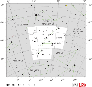
Grus is a constellation in the southern sky. Its name is Latin for the crane, a type of bird. It is one of twelve constellations conceived by Petrus Plancius from the observations of Pieter Dirkszoon Keyser and Frederick de Houtman. Grus first appeared on a 35-centimetre-diameter (14-inch) celestial globe published in 1598 in Amsterdam by Plancius and Jodocus Hondius and was depicted in Johann Bayer's star atlas Uranometria of 1603. French explorer and astronomer Nicolas-Louis de Lacaille gave Bayer designations to its stars in 1756, some of which had been previously considered part of the neighbouring constellation Piscis Austrinus. The constellations Grus, Pavo, Phoenix and Tucana are collectively known as the "Southern Birds".
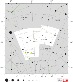
Hydrus is a small constellation in the deep southern sky. It was one of twelve constellations created by Petrus Plancius from the observations of Pieter Dirkszoon Keyser and Frederick de Houtman and it first appeared on a 35-cm (14 in) diameter celestial globe published in late 1597 in Amsterdam by Plancius and Jodocus Hondius. The first depiction of this constellation in a celestial atlas was in Johann Bayer's Uranometria of 1603. The French explorer and astronomer Nicolas Louis de Lacaille charted the brighter stars and gave their Bayer designations in 1756. Its name means "male water snake", as opposed to Hydra, a much larger constellation that represents a female water snake. It remains below the horizon for most Northern Hemisphere observers.
Tucana is a constellation of stars in the southern sky, named after the toucan, a South American bird. It is one of twelve constellations conceived in the late sixteenth century by Petrus Plancius from the observations of Pieter Dirkszoon Keyser and Frederick de Houtman. Tucana first appeared on a 35-centimetre-diameter (14 in) celestial globe published in 1598 in Amsterdam by Plancius and Jodocus Hondius and was depicted in Johann Bayer's star atlas Uranometria of 1603. French explorer and astronomer Nicolas Louis de Lacaille gave its stars Bayer designations in 1756. The constellations Tucana, Grus, Phoenix and Pavo are collectively known as the "Southern Birds".
Triangulum Australe is a small constellation in the far Southern Celestial Hemisphere. Its name is Latin for "the southern triangle", which distinguishes it from Triangulum in the northern sky and is derived from the acute, almost equilateral pattern of its three brightest stars. It was first depicted on a celestial globe as Triangulus Antarcticus by Petrus Plancius in 1589, and later with more accuracy and its current name by Johann Bayer in his 1603 Uranometria. The French explorer and astronomer Nicolas Louis de Lacaille charted and gave the brighter stars their Bayer designations in 1756.
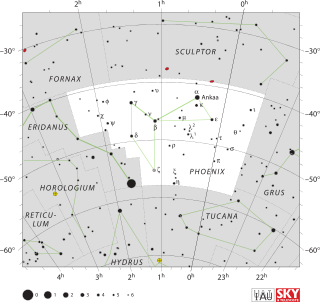
Phoenix is a minor constellation in the southern sky. Named after the mythical phoenix, it was first depicted on a celestial atlas by Johann Bayer in his 1603 Uranometria. The French explorer and astronomer Nicolas Louis de Lacaille charted the brighter stars and gave their Bayer designations in 1756. The constellation stretches from roughly −39° to −57° declination, and from 23.5h to 2.5h of right ascension. The constellations Phoenix, Grus, Pavo and Tucana, are known as the Southern Birds.
Volans is a constellation in the southern sky. It represents a flying fish; its name is a shortened form of its original name, Piscis Volans. Volans was one of twelve constellations created by Petrus Plancius from the observations of Pieter Dirkszoon Keyser and Frederick de Houtman and it first appeared on a 35-cm diameter celestial globe published in 1597 in Amsterdam by Plancius with Jodocus Hondius. The first depiction of this constellation in a celestial atlas was in Johann Bayer's Uranometria of 1603.
Columba is a faint constellation designated in the late sixteenth century, remaining in official use, with its rigid limits set in the 20th century. Its name is Latin for dove. It takes up 1.31% of the southern celestial hemisphere and is just south of Canis Major and Lepus.
Indus is a constellation in the southern sky first professionally surveyed by Europeans in the 1590s and mapped on a globe by Petrus Plancius by early 1598. It was included on a plate illustrating southern constellations in Bayer's sky atlas Uranometria in 1603. It lies well south of the Tropic of Capricorn but its triangular shape can be seen for most of the year from the Equator. It is elongated from north to south and has a complex boundary. The English translation of its name is generally given as the Indian, though it is unclear which indigenous people the constellation was originally supposed to represent.
Pavo is a constellation in the southern sky whose name is Latin for "peacock". Pavo first appeared on a 35-cm (14 in) diameter celestial globe published in 1598 in Amsterdam by Plancius and Jodocus Hondius and was depicted in Johann Bayer's star atlas Uranometria of 1603, and was likely conceived by Petrus Plancius from the observations of Pieter Dirkszoon Keyser and Frederick de Houtman. French explorer and astronomer Nicolas-Louis de Lacaille gave its stars Bayer designations in 1756. The constellations Pavo, Grus, Phoenix and Tucana are collectively known as the "Southern Birds".
In contemporary astronomy, 88 constellations are recognized by the International Astronomical Union (IAU). Each constellation is a region of the sky, bordered by arcs of right ascension and declination. Together they cover the celestial sphere, with their boundaries adopted officially by the International Astronomical Union in 1928 and published in 1930.
Frederick de Houtman was a Dutch explorer, navigator, and colonial governor who sailed on the first Dutch expedition to the East Indies from 1595 until 1597, during which time he made observations of the southern celestial hemisphere and contributed to the creation of 12 new southern constellations.
Petrus Plancius was a Dutch-Flemish astronomer, cartographer and clergyman. He was born as Pieter Platevoet in Dranouter, now in Heuvelland, West Flanders. He studied theology in Germany and England. At the age of 24 he became a minister in the Dutch Reformed Church.
Musca Borealis was a constellation, now discarded, located between the constellations of Aries and Perseus. It was originally called Apes by Petrus Plancius when he created it in 1612. It was made up of a small group of stars, now called 33 Arietis, 35 Arietis, 39 Arietis, and 41 Arietis, in the north of the constellation of Aries.
Sceptrum et Manus Iustitiae was a constellation created by Augustin Royer in 1679 to honor king Louis XIV of France. It was formed from stars of what is today the constellations Lacerta and western Andromeda. Due to the awkward name the constellation was modified and name changed a couple of times, for example some old star maps show Sceptrum Imperiale, Stellio and Scettro, and Johannes Hevelius's star map divides the area between the new Lacerta and as a chain end fettering Andromeda. The connection with the later constellation Frederici Honores, that occupied the chain end of Andromeda, is unclear, except that both represent a regal spire attributed to varying regents.
Pieter Dirkszoon Keyser was a Dutch navigator and celestial cartographer who mapped several constellations on the southern celestial hemisphere.
A star chart is a celestial map of the night sky with astronomical objects laid out on a grid system. They are used to identify and locate constellations, stars, nebulae, galaxies, and planets. They have been used for human navigation since time immemorial. Note that a star chart differs from an astronomical catalog, which is a listing or tabulation of astronomical objects for a particular purpose. Tools utilizing a star chart include the astrolabe and planisphere.
Isaac Habrecht II (1589–1633) was a professor of astronomy and mathematics in Strasbourg. He was also a doctor of medicine and philosophy.
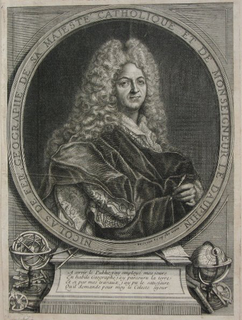
Nicolas de Fer was a French cartographer and geographer. He also was an engraver and publisher. His works focused more on quantity than quality, there were often geographical errors, and they were more artistic than accurate.
This page is based on this Wikipedia article Text is available under the CC BY-SA 4.0 license; additional terms may apply. Images, videos and audio are available under their respective licenses.