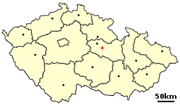
Hluboká is a small village in the Pardubice Region of the Czech Republic. It has around 230 inhabitants.

Gardner Township is located in Sangamon County, Illinois. As of the 2010 census, its population was 4,245 and it contained 1,732 housing units. The township contains the unincorporated communities of Bradfordton and Salisbury.

Úrbel del Castillo is a municipality located in the province of Burgos, Castile and León, Spain. According to the 2004 census (INE), the municipality has a population of 100 inhabitants.

Hardscrabble is a small unincorporated community in Green Township, Madison County, Indiana.
TB Crossroads is an unincorporated community in Northampton County, Virginia, United States.
Iwanowice is a village in Kraków County, Lesser Poland Voivodeship, in southern Poland. It is the seat of the gmina called Gmina Iwanowice. It lies approximately 19 km (12 mi) north of the regional capital Kraków.

Wielka Wieś is a village in Kraków County, Lesser Poland Voivodeship, in southern Poland. It is the seat of the gmina called Gmina Wielka Wieś. It lies approximately 13 km (8 mi) north-west of the regional capital Kraków.
Huta Nowa is a village in the administrative district of Gmina Bieliny, within Kielce County, Świętokrzyskie Voivodeship, in south-central Poland. It lies approximately 6 kilometres (4 mi) east of Bieliny and 27 km (17 mi) east of the regional capital Kielce.
Jaworze is a village in the administrative district of Gmina Zagnańsk, within Kielce County, Świętokrzyskie Voivodeship, in south-central Poland. It lies approximately 3 kilometres (2 mi) south of Zagnańsk and 9 km (6 mi) north-east of the regional capital Kielce.
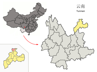
Suijiang County is a county in the northeast of Yunnan province, China, bordering Sichuan province across the Jinsha River to the north and west. It is under the administration of the prefecture-level city of Zhaotong.

Węsiory is a village in the administrative district of Gmina Sulęczyno, within Kartuzy County, Pomeranian Voivodeship, in northern Poland. The village lies approximately 5 kilometres (3 mi) east of Sulęczyno, 26 km (16 mi) south-west of Kartuzy, and 54 km (34 mi) west of the regional capital Gdańsk. It has a population of 754.
Ostrów is a village in the administrative district of Gmina Stare Juchy, within Ełk County, Warmian-Masurian Voivodeship, in northern Poland. It lies approximately 12 kilometres (7 mi) south-west of Stare Juchy, 21 km (13 mi) west of Ełk, and 103 km (64 mi) east of the regional capital Olsztyn.
Kołtki is a village in the administrative district of Gmina Biały Bór, within Szczecinek County, West Pomeranian Voivodeship, in north-western Poland. It lies approximately 7 kilometres (4 mi) north of Biały Bór, 29 km (18 mi) north of Szczecinek, and 161 km (100 mi) east of the regional capital Szczecin.

Deer View is an area within the Eldorado National Forest in El Dorado County, California. It is located 7.25 miles (12 km) northwest of Pollock Pines, at an elevation of 3323 feet.
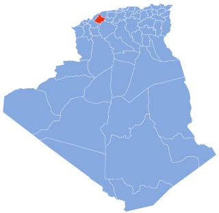
Sidi M'Hamed Ben Ali District is a district of Relizane Province, Algeria.
Cochran is an unincorporated community located in Brunswick County, in the U.S. state of Virginia.
Klisura is a village situated in Doljevac municipality in Serbia.

James I Land is a land area on the northwestern part of Spitsbergen, Svalbard. It is named after King James I of England and Scotland. The 30 kilometer long glacier Sveabreen divides James I Land from Oscar II Land.
Middleton is an unincorporated community in Columbiana County, in the U.S. state of Ohio.
Spring Grove Heights is an unincorporated community in Wayne Township, Wayne County, in the U.S. state of Indiana.
This page is based on this
Wikipedia article Text is available under the
CC BY-SA 4.0 license; additional terms may apply.
Images, videos and audio are available under their respective licenses.
