
Reuss was the name of several historical states located in present-day Thuringia, Germany. Several lordships of the Holy Roman Empire which arose after 1300 and became Imperial Counties from 1673 and Imperial Principalities in the late 18th century were ruled by the House of Reuss.
The Vogtlandkreis is a Landkreis in the southwest of Saxony, Germany, at the borders of Thuringia, Bavaria, and the Czech Republic. Neighbouring districts are Hof, Saale-Orla, Greiz, Zwickau and Erzgebirgskreis. It is the southernmost district in the state.

Gera is a city in the German state of Thuringia. With around 93,000 inhabitants, it is the third-largest city in Thuringia after Erfurt and Jena as well as the easternmost city of the Thüringer Städtekette, an almost straight string of cities consisting of the six largest Thuringian cities from Eisenach in the west, via Gotha, Erfurt, Weimar and Jena to Gera in the east. Gera is the largest city in the Vogtland, and one of its historical capitals along with Plauen, Greiz and Weida. The city lies in the East Thuringian Hill Country, in the wide valley of the White Elster, between Greiz (upstream) and Leipzig (downstream). Gera is located in the Central German Metropolitan Region, approximately 60 kilometres south of Saxony's largest city of Leipzig, 80 km east of Thuringia's capital Erfurt, 120 km west of Saxony's capital Dresden and 90 km north of Bavaria's city of Hof (Saale).
Greiz is a Kreis (district) in the east of Thuringia, Germany. Neighboring districts are Saale-Holzland, Saale-Orla, district-free city Gera, the Burgenlandkreis in Saxony-Anhalt, Altenburger Land, and the two Saxon districts Zwickau and Vogtlandkreis.
Hof is a Landkreis (district) in Bavaria, Germany. It is bounded by the districts of Wunsiedel, Bayreuth, Kulmbach and Kronach, the states of Thuringia and Saxony, and the Czech Republic. The city of Hof is an enclave within the district, as well as being the district's administrative seat.

Vogtland is a region spanning the German states of Bavaria, Saxony and Thuringia and north-western Bohemia in the Czech Republic. It overlaps with and is largely contained within Euroregio Egrensis. The name alludes to the former leadership by the Vögte of Weida, Gera and Plauen.

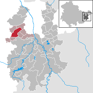
Hilbersdorf is a German municipality in the Thuringian district of Greiz. It belongs to the Verwaltungsgemeinschaft of Ländereck and lies in upper Wipsetal.
Weida can refer to the following:
Münchenbernsdorf is a town in the district of Greiz, in Thuringia, Germany. It is situated approximately 16 km southwest of Gera. The town is seat of a municipal association with eight members.
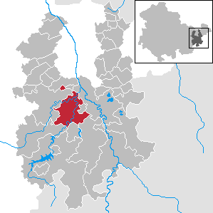
Weida is a town in the district of Greiz, in Thuringia, Germany, situated 12 km south of Gera on the river Weida.

The Weida is a non-navigable river in eastern Thuringia, Germany, left tributary of the White Elster. Most of its course is situated in the district of Greiz.
Schömberg is a village and a former municipality in the district of Greiz, in Thuringia, Germany. Since 31 December 2013, it is part of the town Weida.
Ländereck is a Verwaltungsgemeinschaft in the district of Greiz, in Thuringia, Germany. The seat of the Verwaltungsgemeinschaft is in Seelingstädt.

Auma-Weidatal is a town in the district of Greiz, in Thuringia, Germany. It was named after the town Auma and the river Weida, that flows through the municipality. It was formed on 1 December 2011 by the merger of the former municipalities Auma, Braunsdorf, Göhren-Döhlen, Staitz and Wiebelsdorf. Since January 1996, these and three other municipalities had cooperated in the Verwaltungsgemeinschaft Auma-Weidatal. This Verwaltungsgemeinschaft was disbanded on 1 December 2011. The seat of the municipality and of the former Verwaltungsgemeinschaft is in Auma.

The Osterburg is a castle located conspicuously on a hill in the middle of the town of Weida in the county of Greiz in the German state of Thuringia.
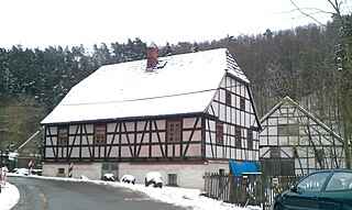
The Eisenhammer Weida is the oldest, working hammer mill in the German state of Thuringia. The iron hammer works lies on the River Auma in the village of Liebsdorf in the borough of Weida, just below the Auma Dam.
The Werdau–Mehltheuer railway is a branch line in the German states of Saxony and Thuringia, originally built and operated by the Royal Saxon State Railways. The section from Werdau to Weida via Wünschendorf is now closed. The section between Weida and Mehltheuer is part of the Gera–Hof link.
