
Aurora is a town in central York Region in the Greater Toronto Area, within the Golden Horseshoe of Southern Ontario, Canada. It is located north of the City of Richmond Hill and is partially situated on the Oak Ridges Moraine. In the Canada 2016 Census, the municipal population of Aurora was the 95th largest in Canada, compared to 97th for the 2006 Census. Aurora has been ranked in the top 10 wealthiest towns in Canada.

Newmarket is a town and regional seat of the Regional Municipality of York in the Canadian province of Ontario. It is part of Greater Toronto in the Golden Horseshoe region of Southern Ontario.

Yonge Street is a major arterial route in the Canadian province of Ontario connecting the shores of Lake Ontario in Toronto to Lake Simcoe, a gateway to the Upper Great Lakes. Until 1999, the Guinness Book of World Records repeated the popular misconception it was 1,896 km (1,178 mi) long, making it the longest street in the world; this was due to a conflation of Yonge Street with the rest of Ontario's Highway 11. Yonge Street is only 56 kilometres (35 mi) long.

Yonge–Eglinton is a neighbourhood in Toronto, Ontario, Canada, at the intersection of Yonge Street and Eglinton Avenue. It is central to the area of Midtown Toronto, one of four central business districts outside Downtown Toronto. The City of Toronto defines its boundaries as Briar Hill Avenue to the north, Yonge Street to the east, Frobisher Avenue and a line in that direction west to Elmsthorpe Avenue, then north to Eglinton Avenue, east to Avenue Road and north to Briar Hill.

North Toronto is a former town and informal district located in the northern part of the Old Toronto district in Toronto, Ontario, Canada. Currently occupying a geographically central location within the city of Toronto, the Town of North Toronto was incorporated in 1890, when much of the area was still farmland, and annexed by the old city of Toronto in 1912. The name is still used to refer to the area in general, although Yonge–Eglinton and Midtown Toronto are officially used.

The Toronto and York Radial Railway was a transit operator providing services to the suburbs of Toronto, Ontario, Canada. It was a subsidiary of the Toronto Railway Company. The company was created by merging four Toronto-area railway operations. The company was part of the empire of railway entrepreneurs Sir William Mackenzie and Donald Mann which included the Canadian Northern Railway and the parent Toronto Railway Company.
The Toronto Suburban Railway was a Canadian electric railway operator with local routes in west Toronto, and a radial (interurban) route to Guelph.
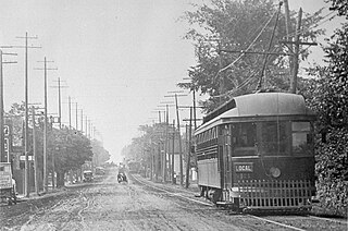
The Metropolitan Street Railway was the operator of the Metropolitan line in the Toronto area that started out as a local horsecar line and transformed itself into an electric radial line extending to Lake Simcoe. In 1904, the railway was acquired by the Toronto and York Radial Railway (T&YRR) and became the T&YRR Metropolitan Division. In 1922, the City of Toronto acquired the T&YRR and contracted Ontario Hydro to manage the four T&YRR lines including the Metropolitan. In 1927, the TTC took over the operation of the Metropolitan Line to Sutton, and renamed it the Lake Simcoe line. In 1930, the TTC closed the Metropolitan Line but shortly reopened the portion between Glen Echo and Richmond Hill operating it as the North Yonge Railways until 1948.

Oak Ridges is an unincorporated community in Ontario, Canada, and has been part of Richmond Hill since 1971. It forms the northern portion of the municipality's boundary, where it borders Aurora. Located about 20 km north of Toronto, it has a population of 38,140 (2016). The town developed around Lake Wilcox, the largest lake in the area, and has continued to expand slowly since its annexation by the Town of Richmond Hill. In the 1990s, Oak Ridges experienced moderate growth, which spurred environmental action by numerous organizations. Population has grown significantly as a result of development initiatives along Bayview Avenue. The Oak Ridges Community Center was built and completed in June 2012 to accommodate community demand.

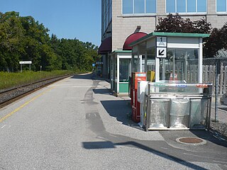
Aurora GO Station is a railway station and bus station in the GO Transit network located on Wellington Street East between Yonge Street and Bayview Avenue in Aurora, Ontario, Canada. It is a stop on the Barrie line train service, and connects with York Region Transit local bus routes, and the GO Express Bus between Newmarket Bus Terminal and Union Station Bus Terminal.
Newmarket GO Station is a train station in the GO Transit network located in the Old Davis Tannery Centre on the north side of Davis Drive East in Newmarket, Ontario, Canada, and is a stop on the Barrie line train service. It is a little over two kilometres east of the Newmarket Bus Terminal, at Davis Drive West and Eagle Street, which is a terminus for GO Bus, York Region Transit and Viva BRT services.

The Dominion Public Building is a five-storey Beaux-Arts neoclassical office building built between 1926 and 1935 for the government of Canada at southeast corner of Front and Bay streets in Toronto, Ontario, Canada.
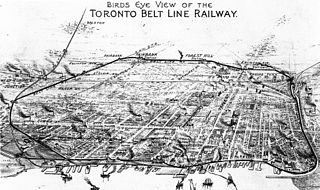
The Toronto Belt Line Railway was built in Toronto, Ontario, Canada in the 1890s. It consisted of two commuter railway lines to promote and service new suburban neighbourhoods outside of the then city limits. Both lines were laid as loops. The longer Don Loop ran north of the city limits, and the shorter Humber Loop ran west of the city limits. The railway was never profitable and it only ran for two years. Today, as part of a rails-to-trail project, the Beltline Trail lies on the right-of-way of the Don Loop.

East Toronto was an incorporated community, currently part of Toronto, Ontario, Canada. It covered much of the present day neighbourhood of the Upper Beaches, stretching up to Danforth Avenue in the north, part of it stretching to Lake Ontario in the south a portion of the present-day neighbourhood, The Beaches. The central street in East Toronto was Main Street, running between Danforth Avenue to Kingston Road. The commercial center of the town was located at the intersection of Main Street and Lake View Avenue. Following the annexation of East Toronto into Old Toronto, Main Street retained its name despite Toronto's conceptual Main Street being historically designated to be Yonge Street.
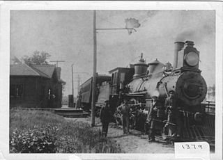
The Schomberg and Aurora Railway was a 36 km long railway in Ontario, Canada, running from the town of Schomberg to Oak Ridges, just south of Aurora. It connected Schomberg to the Metropolitan Line of the Toronto and York Radial Railway (T&YRR) tram service running along Yonge Street, and from there into the Toronto city proper. The service ran for 25 years between 1902 and 1927; the rails were pulled up shortly thereafter.
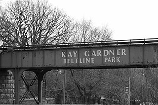
The Beltline Trail is a 9 km cycling and walking rail trail in Toronto, Ontario, Canada. It consists of three sections, the York Beltline Trail west of Allen Road, the Kay Gardner Beltline Park from the Allen to Mount Pleasant Road, and the Ravine Beltline Trail south of Mount Pleasant Cemetery through the Moore Park Ravine. Built on the former right-of-way of the Toronto Belt Line Railway, the linear park passes through the neighbourhoods of Rosedale, Moore Park, Forest Hill, Chaplin Estates, and Fairbank.

Beginning operation in 1861, the Yonge streetcar line was the first streetcar line in Toronto and the first in Canada. It started off as a horsecar line and closed in 1954 operating two-unit trains of Peter Witt motors pulling a trailer. Under the Toronto Transportation Commission, the Yonge line was the busiest and most congested streetcar line in the city leading to its replacement in 1954 by the Yonge Subway line, also Toronto's first and the first in Canada.
Teddington Park is a neighbourhood in Toronto, Ontario, Canada. It is bordered by Yonge Street to the west and Bayview Avenue to the east, and from Snowden Road in the south to north of Glen Echo Road and Rosedale Golf Club. Development occurred in and around the 1930s, and was farmland before that time.
