
This is a demography of the population of Bhutan including population density, ethnicity, education level, health of the populace, economic status, religious affiliations and other aspects of the population.

Trashigang District is Bhutan's easternmost dzongkhag (district).

The Kingdom of Bhutan is divided into 20 districts. Bhutan is located between the Tibet Autonomous Region of China and India on the eastern slopes of the Himalayas in South Asia.

Paro District is a district (dzongkhag), valley, river and town in Bhutan. It is one of the most historic valleys in Bhutan. Both trade goods and invading Tibetans came over the pass at the head of the valley, giving Paro the closest cultural connection with Tibet of any Bhutanese district. The dominant language in Paro is Dzongkha, the national language.
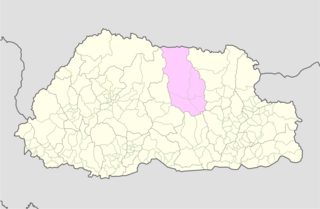
Bumthang District is one of the 20 dzongkhag (districts) comprising Bhutan. It is the most historic dzongkhag if the number of ancient temples and sacred sites is counted. Bumthang consists of the four mountain valleys of Ura, Chumey, Tang and Choekhor ("Bumthang"), although occasionally the entire district is referred to as Bumthang Valley.

Gasa District or Gasa Dzongkhag is one of the 20 dzongkhags (districts) comprising Bhutan. The capital of Gasa District is Gasa Dzong near Gasa. It is located in the far north of the county and spans the Middle and High regions of the Tibetan Himalayas. The dominant language of the district is Dzongkha, which is the national language. Related languages, Layakha and Lunanakha, are spoken by semi-nomadic communities in the north of the district. The People's Republic of China claims the northern part of Gasa District.

Pemagatshel is one of the 20 districts of Bhutan.

Samtse District is one of the 20 dzongkhags (districts) comprising Bhutan. It comprises two subdistricts (dungkhags): Tashicholing and Dophuchen. They are further subdivided into 15 gewogs. The Samtse district covers a total area of 1304 sq km.
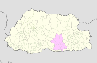
Zhemgang District, is one of the 20 dzongkhags (districts) comprising Bhutan. It is bordered by Sarpang, Trongsa, Bumthang, Mongar and Pemagatshel Districts, and borders Assam in India to the south. The administrative center of the district is Zhemgang.

Darrang is an administrative district in the state of Assam in India. The district headquarters are located at Mangaldoi. The district occupies an area of 1585 km2.

Bhutan, officially the Kingdom of Bhutan, is a landlocked South Asian country situated in the Eastern Himalayas, between China in the north and India in the south. A mountainous country, Bhutan is known locally as "Druk Yul" or "Land of the Thunder Dragon", a name reflecting the cultural heritage of the country. The exonym Bhutan likely derives from the Prakrit hybrid word Bhŏṭṭaṃta, a name referring to its geographical proximity to Tibet (Bhŏṭṭa). Nepal and Bangladesh are located near Bhutan but do not share a border with it. The country has a population of over 727,145 and a territory of 38,394 square kilometres (14,824 sq mi) and ranks 133rd in land area and 160th in population. Bhutan is a constitutional monarchy with a king as the head of state and a prime minister as the head of government. Vajrayana Buddhism is the state religion and the Je Khenpo is the head of the state religion.

A gewog, in the past also spelled as geog, is a group of villages in Bhutan. The head of a gewog is called a gup. Gewogs form a geographic administrative unit below dzongkhag districts, and above Dzongkhag Thromde class B and Yenlag Thromde municipalities. Dzongkhag Thromde class A municipalities have their own independent local government body.

Jaigaon is a census town in Alipurduar subdivision under Kalchini Block of Alipurduar district in the state of West Bengal, India. It is located on the country's border with Bhutan, and Bhutan Gate separates the two countries. Phuentsholing is the Bhutan's nearest city to Jaigaon. Bhutan does not have domestic roads linking to all its towns, so uses roads passing through Jaigaon to reach such destinations as Samtse, Gomtu, Nganglam and Samdrup Jongkhar.
Chirang District is an administrative district in the Bodoland Territorial Region of Assam state in the North-East of India.

Baksa district is an administrative district in the Bodoland Territorial Region of Assam, one of the North-Eastern states of India. The administrative headquarters is at Mushalpur. Manas National Park is a part of this district.

Alirajpur is one of the 52 districts of Madhya Pradesh state in India. It was created from Alirajpur, Jobat and Bhabra tehsils of the former Jhabua district on 17 May 2008. It is the least literate district in India as per Census 2011. Alirajpur is the administrative headquarters of the district. The district occupies an area of 2,165.24 square kilometres (836.00 sq mi), and at the 2011 census had a population of 728,999. It includes the city of Alirajpur.
Ngangla Gewog is a gewog of Zhemgang District, Bhutan, bordering India. Ngangla Gewog is also a part of Panbang Dungkhag (sub-district), along with Goshing, Bjoka, and Phangkhar Gewogs.
Sangbay or Sangbaykha Gewog is a gewog of Haa District, Bhutan. It is one of the western gewogs of the Haa district sharing borders with the Samtse District, India's Sikkim state and China's Chumbi Valley. The latter border has been contested by China, which claims the Doklam region as its territory. In recent years, China has begun to build villages in its claimed area.
Lhokpu, also Lhobikha or Taba-Damey-Bikha, is one of the autochthonous languages of Bhutan spoken by the Lhop people. It is spoken in southwestern Bhutan along the border of Samtse and Chukha Districts. Van Driem (2003) leaves it unclassified as a separate branch within the Sino-Tibetan language family.
Norgaygang Gewog is a gewog of Samtse District, Bhutan. It is located at the extreme northwest of the Samtse District bordering on India's West Bengal (Kalimpong) and Sikkim provinces. It has the Haa District to the northeast and Samtse's Tendruk Gewog to the southeast.
