Avonmouth Light Railway

Last updated

Railways around Avonmouth in 1914.
Avonmouth Light Railway in blue Avonmouth rly map 1914.png
Railways around Avonmouth in 1914.
Avonmouth Light Railway in blue

The Avonmouth Light Railway(ALR) was a nominally independent railway company operating a short standard-gauge branch line from a point on what is now the Severn Beach Line near Avonmouth Docks station in Bristol to a Bristol Corporation electricity installation east of the main entrance to Avonmouth Docks. Its promoters had aspirations which were never fulfilled.

Contents

History

The ALR was a project of the Kingsweston estate owned by the squire of Kingsweston, Dr Philip Napier Miles, and its headquarters were in the Kingsweston estate office in High Street, Shirehampton. [1] This estate had owned much of the land in the area; Dr Miles' father, Philip William Skynner Miles MP, had been responsible for promoting Avonmouth Docks, opened in 1877 on a large tract of his marshland.

Acts of Parliament

The plan for the line was deposited in November 1902, [2] and an order for its construction was obtained in 1903 under the Light Railways Act of 1896; [3] but with the task threatening not to be completed before the period specified in the Act expired, renewal was sought several times and obtained from 1909 to 1912, finally through the Avonmouth Light Railway (Revival and Extension of Time) Order of 1912, again under the Light Railways Act of 1896. [4] The line was nevertheless not completed to the full original specification.

Relation to other railway systems

The ALR was planned to meet up with other industrial railways developing to serve enterprises further north in the Avonmouth area, but the intended contact never took place. The book of reference of the line [5] specifies that it was to run from Shirehampton (of which Avonmouth was a part at the time) to Henbury, but it never crossed the parish boundary into Henbury. [6]

Construction

The ALR's consulting engineers were Kirkland and Capper of Westminster. [7]

Operation

The line eventually opened in 1908, probably on 1 April, and was closed on an unknown date but probably about 1931. [8]

The line was operated from the start by the Great Western and Midland Joint Railway Committee [9] and transferred in 1927 to the ownership of the Joint Committee's successor companies, the London, Midland and Scottish Railway and the (post-Grouping) Great Western Railway. [10]

The ALR never carried paying passengers, and must have been intended solely to transport coal from the Joint Committee's sidings to the electricity installation, if this was indeed a generating station.

Little is known about the locomotives and rolling stock, operational history or personnel of the line. There are occasional mentions of it in oral history memoirs, [11] but nothing that illuminates its business with precision. It appears that the Great Western Railway kept an engine in a shed by Portview Road to share the duties of servicing a coal yard and taking trucks along the ALR. It was distinguished by the fact that 100% of its staff were called up in the First World War – that is, both of them. [12]

Route

The line started from a Bristol-facing junction with sidings on the Clifton Extension Railway (which ran from Narroways Hill Junction and Kingswood Junction in north Bristol to the port of Avonmouth). This junction was located 30 chains (600 m) east of Avonmouth Docks joint station. The stub of the line at its southern end appears as a siding on an Ordnance Survey map of 1949. [13] It crossed several streets on the level in the expanding suburb before setting out across the fields of Avonmouth farm in the direction of a facility variously described as a Bristol Corporation electricity sub-station and as a generating station, and terminating on the western side of this facility in what is now a widened St Andrew's Road. It was about 58 chains (1,200 m) long. There is some doubt about whether it was ever extended further. Almost no trace of the line remains in 2015. Gaps between buildings in Portview Road, Davis Street and Avonmouth Road could be discerned by the knowledgeable and interpreted as the course of the line, but building has taken place in some gaps, and the only ones remaining are on both sides of Davis Street (west of numbers 28 and 31) and opposite the Miles Arms hotel in Avonmouth Road. [14] The fields north of the village across which it went have all been built over with warehousing and other commercial development as Avonmouth has expanded, but the disturbed ground marking its course can clearly be followed in post-WW2 aerial photography, [10] cutting across fields still showing the ridge-and-furrow pattern of pre-modern arable farming. [14] The electricity station or sub-station which was its destination is still in existence but derelict. [15]

Related Research Articles

<span class="mw-page-title-main">Severn Beach</span> Human settlement in England

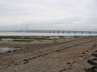
Severn Beach is a village on the Severn Estuary in South Gloucestershire, England. The eastern portal of the Severn Tunnel is on the outskirts of the village. The Severn footpath – on the sea wall – is part of the Severn Way that leads from Gloucester, Slimbridge and the Second Severn Crossing. Extensive sea defences have been constructed and this provides a popular walkway along its length. Originally, the Severn Way finished at Severn Beach, but it has been extended to Bristol.

<span class="mw-page-title-main">Avonmouth</span> Port and suburb of Bristol, England

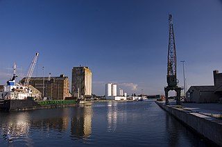
Avonmouth is a port and outer suburb of Bristol, England, facing two rivers: the reinforced north bank of the final stage of the Avon which rises at sources in Wiltshire, Gloucestershire and Somerset; and the eastern shore of the Severn Estuary. Strategically the area has been and remains an important part of the region's maritime economy particularly for larger vessels for the unloading and exporting of heavier goods as well as in industry including warehousing, light industry, electrical power and sanitation. The area contains a junction of and is connected to the south by the M5 motorway and other roads, railway tracks and paths to the north, south-east and east.

<span class="mw-page-title-main">Sharpness</span> Human settlement in England

Sharpness is an English port in Gloucestershire, one of the most inland in Britain, and eighth largest in the South West England region. It is on the River Severn at grid reference SO669027, at a point where the tidal range, though less than at Avonmouth downstream, is still large.

<span class="mw-page-title-main">Severn Beach line</span> Railway in Bristol and Gloucestershire, England

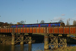
The Severn Beach line is a local railway line in Bristol and Gloucestershire, England, which runs from Bristol Temple Meads to Severn Beach, and used to extend to Pilning. The first sections of the line were opened in 1863 as part of the Bristol Port Railway and Pier; the section through Bristol was opened in 1875 as the Clifton Extension Railway.

<span class="mw-page-title-main">Shirehampton</span> Human settlement in England

Shirehampton is a district of Bristol in England, near Avonmouth, at the northwestern edge of the city.

The Bristol and Gloucester Railway was a railway company opened in 1844 to run services between Bristol and Gloucester. It was built on the 7 ftBrunel gauge, but it was acquired in 1845 by the 4 ft 8+12 instandard gauge Midland Railway, which also acquired the Birmingham and Gloucester Railway at the same time.

<span class="mw-page-title-main">Avonmouth Docks</span> Port in United Kingdom

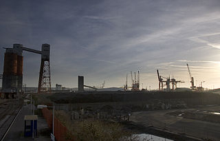
The Avonmouth Docks are part of the Port of Bristol, in England. They are situated on the northern side of the mouth of the River Avon, opposite the Royal Portbury Dock on the southern side, where the river joins the Severn estuary, within Avonmouth.
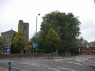
<span class="mw-page-title-main">Montpelier railway station</span> Railway station in Bristol, England

Montpelier railway station is on the Severn Beach Line and serves the district of Montpelier in Bristol, England. It is 2.85 miles (4.59 km) from Bristol Temple Meads. Its three letter station code is MTP. The station has a single platform, serving trains in both directions. As of 2015 it is managed by Great Western Railway, which is the third franchise to be responsible for the station since privatisation in 1997. They provide all train services at the station, mainly a train every 30 minutes in each direction.

<span class="mw-page-title-main">Clifton Down railway station</span> Railway station in Bristol, England

Clifton Down railway station is on the Severn Beach line and serves the district of Clifton in Bristol, England. It is 3.9 miles (6.3 km) from Bristol Temple Meads. Its three letter station code is CFN. The station has two platforms, each serving trains in one direction only. As of 2015 it is managed by Great Western Railway, which is the third franchise to be responsible for the station since privatisation in 1997. They provide all train services at the station, mainly a train every 30 minutes in each direction.

<span class="mw-page-title-main">Sea Mills railway station</span> Railway station in Bristol, England

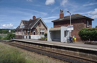
Sea Mills railway station is on the Severn Beach Line and serves the district of Sea Mills and nearby Westbury on Trym in Bristol, England. It is 6 miles (9.7 km) from Bristol Temple Meads, situated at the confluence of the River Avon and River Trym and near the A4 Bristol Portway. Its three letter station code is SML. The station has a single platform which serves trains in both directions. As of 2015 it is managed by Great Western Railway, which is the third franchise to be responsible for the station since privatisation in 1997. They provide all train services at the station, mainly a train every 30 minutes in each direction.

<span class="mw-page-title-main">Shirehampton railway station</span> Railway station in Bristol, England

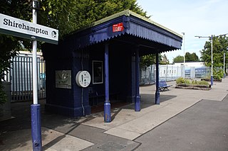
Shirehampton railway station is on the Severn Beach Line and serves the district of Shirehampton in Bristol, England. It is 7.6 miles (12.2 km) from Bristol Temple Meads. Its three letter station code is SHH. The station has a single platform which serves trains in both directions. As of 2015 it is managed by Great Western Railway, which is the third franchise to be responsible for the station since privatisation in 1997. They provide all train services at the station, mainly a train every 30 minutes in each direction.

<span class="mw-page-title-main">Avonmouth railway station</span> Railway station in Bristol, England

Avonmouth railway station is located on the Severn Beach Line and serves the district of Avonmouth in Bristol, England. It is 9.0 miles (14.5 km) from Bristol Temple Meads. Its three letter station code is AVN. The station has two platforms, on either side of two running lines. As of 2015 it is managed by Great Western Railway, which is the third franchise to be responsible for the station since privatisation in 1997. They provide all train services at the station, mainly a train every 30 minutes to Bristol Temple Meads and one every hour to Severn Beach.

The Bristol Port Railway and Pier was a railway in Bristol, England.

<span class="mw-page-title-main">Henbury Loop Line</span>

The Henbury Loop Line, also known as the Filton to Avonmouth Line, is a railway line following the boundary between Bristol and South Gloucestershire between the Severn Beach Line at Hallen Marsh Junction, Avonmouth and the Cross Country Route/South Wales Main Line at Filton. It is currently only used for freight.

Rail services in the West of England refer to passenger rail journeys made in the Bristol commuter area. 17 million passenger rail journeys were made in 2019-20 within the Gloucestershire, Wiltshire and Bristol/Bath region.

Kingsweston was a ward of the city of Bristol. The three districts in the ward were Coombe Dingle, Lawrence Weston and Sea Mills. The ward takes its name from the old district of Kings Weston, now generally considered part of Lawrence Weston. Following a Local Government Boundary Commission review in 2015 ward boundaries were redrawn and Kingsweston ward is now split between the Stoke Bishop ward and the Avonmouth and Lawrence Weston ward.

<span class="mw-page-title-main">Clifton Extension Railway</span>

The Clifton Extension Railway was a joint railway in Bristol, owned by the Great Western Railway (GWR) and the Midland Railway (MR) companies.

<span class="mw-page-title-main">Chittening</span> Human settlement in England

Chittening is an industrial estate in Avonmouth, Bristol, England, bypassed by the A403 road, near the River Severn. It lies within the city boundary of Bristol, in Avonmouth ward, but used to be beyond it, in historic Gloucestershire, on former marshland at the southern end of the Vale of Berkeley.

<span class="mw-page-title-main">North Filton Platform railway station</span> Former railway station in England

North Filton Platform was a railway station which served the northern part of Filton, Gloucestershire, England. It was on the railway line between Filton and Avonmouth, and was situated on the western side of Gloucester Road.

Bristol Rail Campaign is a Bristol-based campaign group, calling for better rail transport in the Bristol area.

References

  1. Letterhead of surviving correspondence.
  2. The National Archives [TNA] document MT 54/384; Bristol Record Office [BRO] document 07790/76. The official depositing of the plans for parliamentary scrutiny is noticed in The London Gazette, 30 June 1903, p. 4095, col. b. Objections and correspondence can be found in BRO document SMV/7/1/4/25.
  3. "Avonmouth Light Railway, 1903". National Archives. Retrieved 14 February 2016.
  4. "Avonmouth Light Railway (Revival and Extension of Time), 1912". National Archives. Retrieved 14 February 2016.
  5. Gloucestershire Archives [GA] document Q/RUm/567.
  6. Coates, Richard (2016) "The Avonmouth Light Railway." Transactions of the Bristol and Gloucestershire Archaeological Society 134, 231-250.
  7. "Obituary of Professor David Sing Capper (1864-1926)". Grace’s guide. Retrieved 30 December 2014.
  8. Mitchell, Vic, and Keith Smith (2004) Branch lines around Avonmouth. Midhurst: Middleton Press, dates in notes to map XII.
  9. Memorandum of arrangements between Great Western Railway Company, Midland Railway Company and Avonmouth Light Railway Company, Gloucestershire, for supply of rolling stock and through traffic, [to run from] 1 April 1908 to 31 July 1918. TNA document RAIL 252/1544
  10. 1 2 "Light Railway Order: London Midland and Scottish and Great Western Railway Companies (Avonmouth Light Railway Transfer and Amendment), 1927. TNA document MT 58/481". National Archives.
  11. Helme, Judy, and Sue Davies, eds (1999) A mouthful of memories. An oral history of Avonmouth; and (2001) Another mouthful of memories. An oral history of Avonmouth. Privately published.
  12. Mullay, Alexander J. (2014). "Manpower (and horsepower)". Blighty's railways: Britain's railways in the First World War. Stroud: Amberley Publishing. Retrieved 30 December 2014.
  13. Coates, Richard. "A short history of West Town" (PDF). Shire. Retrieved 14 February 2016.
  14. 1 2 "Bristol - Know Your Place". Maps.bristol.gov.uk. Retrieved 3 July 2015.
  15. andy hebden (18 April 2009). "Severn Beach, 18th April 2009 | Flickr - Photo Sharing!". Flickr.com. Retrieved 3 July 2015.