
Normandy is a geographical and cultural region in Northwestern Europe, roughly coextensive with the historical Duchy of Normandy.
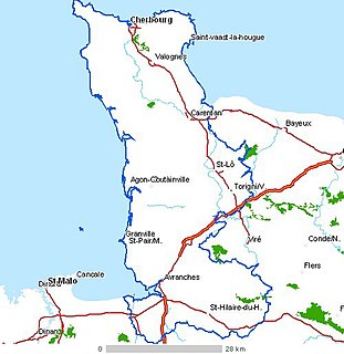
Manche is a coastal French department in Normandy, on the English Channel, which is known as La Manche, literally "the sleeve", in French.

Lower Normandy is a former administrative region of France. On 1 January 2016, Lower and Upper Normandy merged becoming one region called Normandy.

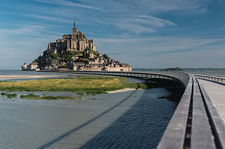
Le Mont-Saint-Michel is a tidal island and mainland commune in Normandy, France.

Maine is one of the traditional provinces of France. It corresponds to the former County of Maine, whose capital was also the city of Le Mans. The area, now divided into the departments of Sarthe and Mayenne, counts about 857,000 inhabitants.
The Cotentin Peninsula, also known as the Cherbourg Peninsula, is a peninsula in Normandy that forms part of the northwest coast of France. It extends north-westward into the English Channel, towards Great Britain. To its west lie the Channel Islands and to the southwest lies the peninsula of Brittany.
Avranches is a commune in the Manche department in the Normandy region in northwestern France. It is a subprefecture of the department. The inhabitants are called Avranchinais.

Granville is a commune in the Manche department and region of Normandy, northwestern France. The chef-lieu of the canton of Granville and seat of the Communauté de communes de Granville, Terre et Mer, it is a seaside resort and health resort of Mont Saint-Michel Bay, at the end of the Côte des Havres, a former cod-fishing port and the first shellfish port of France. It is sometimes nicknamed "Monaco of the North" by virtue of its location on a rocky promontory.

Normandy was a province in the North-West of France under the Ancien Régime which lasted until the latter part of the 18th century. Initially populated by Celtic tribes in the West and Belgic tribes in the North East, it was conquered in AD 98 by the Romans and integrated into the province of Gallia Lugdunensis by Augustus. In the 4th century, Gratian divided the province into the civitates that constitute the historical borders. After the fall of Rome in the 5th century, the Franks became the dominant ethnic group in the area, built several monasteries, and replaced the barbarism of the region with the civilization of the Carolingian Empire. Towards the end of the 8th century, Viking raids devastated the region, prompting the establishment of the Duchy of Normandy in 911. After 150 years of expansion, the borders of Normandy reached relative stability. These old borders roughly correspond to the present borders of Lower Normandy, Upper Normandy and the Channel Islands. Mainland Normandy was integrated into the Kingdom of France in 1204. The region was badly damaged during the Hundred Years War and the Wars of Religion, the Normans having more converts to Protestantism than other peoples of France. In the 20th century, D-Day, the 1944 Allied invasion of Western Europe, started in Normandy. In 1956, mainland Normandy was separated into two regions, Lower Normandy and Upper Normandy, which were reunified in 2016.

Hauteville-la-Guichard is a commune in the Manche department in Normandy in north-western France.
The Abrincatui were a Gallic tribe dwelling in the south of the Cotentin Peninsula during the Roman period.

Cerisy-la-Forêt is a commune in the Manche department of Normandy in north-western France. It has a population of 1,034 inhabitants and possesses an important environmental and architectural heritage.

Hiesville is a commune in the Manche department in north-western France. A small commune, Hiesville covers an area of just 4.03 km2 (1.56 sq mi). It is bounded by Boutteville to the north, Blosville to the west, Sainte-Marie-du-Mont to the east, and Vierville to the south, and lies several kilometres from the Normandy coast.

Saint-James is a commune in the Manche department in Normandy in north-western France. On 1 January 2017, the former communes of Argouges, Carnet, La Croix-Avranchin, Montanel, Vergoncey and Villiers-le-Pré were merged into Saint-James.
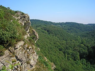
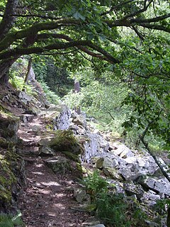
The Rock of Oëtre is situated in the middle of Norman Switzerland, in the commune of Saint-Philbert-sur-Orne, not far from the border between the départements of Calvados and Orne, and almost equidistant from Thury-Harcourt and Écouché. It is one of the most prestigious lookouts in the west of France.
Normandie-Maine Regional Natural Park is a protected area of forest and bocage located in the French regions of Normandy and Pays de la Loire.

The Mont-Saint-Michel Abbey is an abbey located within the city and island of Mont-Saint-Michel in Normandy, in the department of Manche.

Normandy is the northwesternmost of the eighteen regions of France, roughly coextensive with the historical Duchy of Normandy.
The Avranches massacre took place on 21 November 1793 in the context of the savage "Vendée" civil war that broke out in the west of France between 1793 and 1796, during the French Revolution. It involved the killing by firing squad at Avranches of approximately 800 prisoners.

The Prieuré de l'Oiselière is a priory located at Saint-Planchers, near Granville, in France. Nestled in a valley bordering the watercourse that bears its name, surrounded by fortified walls and moats, its history dates back to the 12th century. It was a dependency of the abbots of Mont-Saint-Michel who organised the cultivation of the fields and the woods and collected taxes. It was also a local justice court.
