
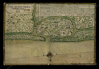
The Mosquito Coast is the area along the eastern coast of present-day Nicaragua and Honduras. It was named after the local Miskito Nation and was long dominated by British interests and known as the Mosquito Kingdom. From 1860 suzerainty of the area was transferred to Nicaragua with the name Mosquito Reserve, and in November 1894 the Mosquito Coast was militarily incorporated into Nicaragua. However, in 1960, the northern part was granted to Honduras by the International Court of Justice.

The Miskitos are a native people in Central America. Their territory extends from Cape Camarón, Honduras, to Río Grande de Matagalpa, Nicaragua, along the Mosquito Coast, in the Western Caribbean Zone. Their population is estimated at 700,000 people as of 2021, according to the official Miskito Database.

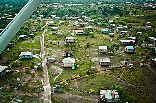
Bluefields is the capital of the South Caribbean Autonomous Region in Nicaragua. It was also the capital of the former Kingdom of Mosquitia, and later the Zelaya Department, which was divided into North and South Caribbean Coast Autonomous Regions. It is located on Bluefields Bay at the mouth of the Bluefields River in the municipality of the same name.

The Misumalpan languages are a small family of languages spoken by indigenous peoples on the east coast of Nicaragua and nearby areas. The name "Misumalpan" was devised by John Alden Mason and is composed of syllables from the names of the family's three members Miskito, Sumo languages and Matagalpan. It was first recognized by Walter Lehmann in 1920. While all the languages of the Matagalpan branch are now extinct, the Miskito and Sumu languages are alive and well: Miskito has almost 200,000 speakers and serves as a second language for speakers of other indigenous languages in the Mosquito Coast. According to Hale, most speakers of Sumu also speak Miskito.
Mískito Coast Creole or Nicaragua Creole English is an English-based creole language spoken in coastal Nicaraguan region of Mosquito Coast on the Caribbean Sea; its approximately 18,000 speakers are spread over a number of small villages. The region is today administratively separated into two autonomous regions: North Caribbean Coast and South Caribbean Coast. Mosquito is the nickname that is given to the region and earlier residents by early Europeans who visited and settled in the area. The term "Miskito" is now more commonly used to refer to both the people and the language.
Puerto Cabezas is a municipality and city in Nicaragua. It is the capital of Miskito nation in the North Caribbean Coast Autonomous Region.

Puerto Lempira or Auhya Yari is the Miskito capital of the Gracias a Dios department in northeastern Honduras, located on the shores of the Caratasca Lagoon. Though it does not have paved roads, it is the largest town in the La Mosquitia region.

Miskito is a Misumalpan language spoken by the Miskito people in northeastern Nicaragua, especially in the North Caribbean Coast Autonomous Region, and in eastern Honduras.
Waspam is a Miskito town and a municipality in the North Caribbean Coast Autonomous Region of Nicaragua.

Prinzapolka is a Miskito municipality in the North Caribbean Coast Autonomous Region of Nicaragua.

The Miskito Cays are an archipelago with an area of 27 km2 located off shore in the northeastern Caribbean coast of Nicaragua, part of the North Caribbean Coast Autonomous Region. The Miskito Cays are composed of 76 formations that include estuaries, coral reefs, cays, seagrass beds, and islets, of which 12 of the formations are covered with vegetation and consequently form islands which are lined with white sand beaches.

The Nakunta River is a river in the Gracias a Dios Department of Honduras that exits into the Caratasca Lagoon a few miles south of Puerto Lempira. It is 115 kilometers (71 mi) in length.
The Black River settlement was a British settlement on the Mosquito Coast in Central America. It was established in 1732 by a British colonist named William Pitt. The settlement, made on territory claimed but never really controlled by Spain, was evacuated in 1787 pursuant to terms of the Anglo-Spanish Convention of 1786. The Spanish then attempted to colonize the area, but the local Miskitos massacred most of its inhabitants on September 4, 1800. The settlement was abandoned, and its remains can still be seen near the village of Palacios in the Honduran department of Gracias a Diós.
The Miskito Sambu, also known simply as the Miskito, are an ethnic group of mixed cultural ancestry occupying a portion of the Caribbean coast of Central America known as the Mosquito Coast region. Although older records, beginning with Spanish documents of the early 18th century, refer to the group as "Mosquitos Zambos", modern ethnographic terminology uses the term Miskito.

Afro-Nicaraguans are Nicaraguans of Sub-Saharan African descent. Five main distinct ethnic groups exist: The Creoles who descend from Anglo-Caribbean countries and many of whom still speak Nicaragua English Creole, the Miskito Sambus descendants of Spanish slaves and indigenous Central Americans who still speak Miskito and/or Miskito Coast Creole, the Garifunas descendents of Zambos expelled from St. Vincent who speak Garifuna, the Rama Cay zambos a subset of the Miskito who speak Rama Cay Creole, and the descendants of those enslaved by the Spanish.

Afro-Hondurans or Black Hondurans are Hondurans of Sub-Saharan African descent. Research by Henry Louis Gates and other sources regards their population to be around 1-2%. They descended from: enslaved Africans by the Spanish, as well as those who were enslaved from the West Indies and identify as Creole peoples, and the Garifuna who descend from exiled zambo Maroons from Saint Vincent. The Creole people were originally from Jamaica and other Caribbean islands, while the Garifuna people were originally from Saint Vincent and the Grenadines. Garifunas arrived in the late seventeen hundreds and the Creole peoples arrived during the eighteen hundreds. About 600,000 Hondurans are from Garífuna descent that are a mix of African and indigenous as of Afro Latin Americans. Honduras has one of the largest African community in Latin America.
The Wawa River is a river located in the North Caribbean Coast Autonomous Region of Nicaragua that drains to the Caribbean Sea. It flows southeast through northeast Nicaragua to the Mosquito Coast region. The river joins Laguna de Karata, south of Puerto Cabezas, before exiting to the Caribbean Sea.
Settlement of English people along the Caribbean Coast, or Miskito Coast, of Nicaragua began in 1633. The area was controlled by Britain until 1860, and eventually integrated into Nicaragua by 1894. The Miskito Coast region divided into two autonomous regions within Nicaragua after 1987.

Providencia and Santa Catalina Islands is a municipality of the department of Archipelago of San Andrés, Providencia and Santa Catalina in insular Colombian region, on the northern coast of Providencia Island as well as several uninhabited cayes to the North and East) had a population of 5,011 at the 2007 official estimates, and receives just 15,000 visitors per year. The island is one of Colombia's top scuba diving destinations, with a 32 km long barrier reef protecting the Eastern coast of the island.
