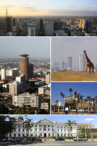
Nairobi is the capital and largest city of Kenya. The name is derived from the Maasai phrase Enkare Nairobi, which translates to 'place of cool waters', a reference to the Nairobi River which flows through the city. The city proper had a population of 4,397,073 in the 2019 census. The city is commonly referred to as The Green City in the Sun.

Kenya, officially the Republic of Kenya, is a country in East Africa. With a population of more than 47.6 million in the 2019 census, Kenya is the 28th-most-populous country in the world and 7th most populous in Africa. Kenya's capital and largest city is Nairobi, while its oldest and second-largest city, is the major port city of Mombasa, situated on Mombasa Island in the Indian Ocean and the surrounding mainland. Mombasa was the capital of the British East Africa Protectorate, which included most of what is now Kenya and southwestern Somalia, from 1889 to 1907. Other important cities include Kisumu and Nakuru. Kenya is bordered by South Sudan to the northwest, Ethiopia to the north, Somalia to the east, Uganda to the west, Tanzania to the south, and the Indian Ocean to the southeast. Kenya's geography, climate and population vary widely, ranging from cold snow-capped mountaintops with vast surrounding forests, wildlife and fertile agricultural regions to temperate climates in western and rift valley counties and further on to dry less fertile arid and semi-arid areas and absolute deserts.

Busia is a county in the former Western Province of Kenya. It is located directly east of the border town of Busia, Uganda, and borders Lake Victoria to the southwest, Siaya County to the southeast, and Bungoma County and Kakamega County to the east. The county is composed of six sub-counties, and had a population of 893,681 as of the most recent census in 2019.

Siaya County is one of the counties in the former Nyanza Province in western Kenya. It is bordered by Busia County to the north, Kakamega County, and Vihiga County to the northeast and Kisumu County to the southeast. It shares a water border with Homa Bay County which is located south of Siaya County. The total area of the county is approximately 2,496.1 km2. The county lies between latitude 0° 26' to 0° 18' north and longitude 33° 58' east and 34° 33' west. Siaya has been split up into six new districts. Under the 2010 Constitution, the role of the districts is still unclear as much of the administrative authority was transferred to the county. The capital is Siaya, although the largest town is Bondo.

Kiambu County is a county in the former Central Province of Kenya. Its capital is Kiambu and its largest town is Thika town. Kiambu County is the second most populous county in Kenya after Nairobi County. Kiambu County borders Nairobi and Kajiado Counties to the South, Machakos to the East, Murang'a to the North and North East, Nyandarua to the North West, and Nakuru to the West. It has a population of 2,417,735.

Machakos County is one of the 47 counties of Kenya, which came into being because of the devolved system of governance occasioned by the 2010 constitution of Kenya. The country's first administrative headquarters are in Machakos Town, which is the largest town in the county. The county had a population of 1,421,932 as of 2019. The county borders Nairobi and Kiambu counties to the west, Embu to the north, Kitui to the east, Makueni to the south, Kajiado to the south west, and Muranga and Kirinyaga to the north west.
Isiolo County is a county in the former Eastern Province of Kenya. Its population is 268,002 and its capital and largest city is Isiolo. Isiolo County is to be the first county to be developed as part of the Kenya Vision 2030 program. Other upcoming urban centres are: Garbatulla, Modogashe, Kinna, Merti and Oldonyiro. The county is home to Sakuye and Borana tribes but also has a significant number of people from Turkana, Samburu, Gabra, Garre and Meru communities.

Nyamira County is a county in the former Nyanza Province of Kenya. Formally a district, Nyamira was hived off Kisii District in 1989, and it shares common boundaries with what was known as Nyamira District. The main cash crops grown are bananas and tea. The county has a population of 605,576. Its capital and largest town is Nyamira, with an urban population of around 41,668 The county is also referred to as North Kisii.

Makueni County is a county in the former Eastern Province of Kenya. Its capital town is Wote.The largest town is Emali town, which is also an important market and stop over for the Standard Gauge Railway (SGR). Emali town is multicultural and adds diversity to Makueni county.The county has a population of 987,653. The county lies between Latitude 1° 35' and 2° 59' South and Longitude 37° 10' and 38° 30' East. It borders Machakos County to the North, Kitui County to the East, Taita Taveta County to the South and Kajiado County to the West and covers an area of 8,008.9 km2.
Migori county 044, also known as Suna-Migori, is a multi-ethnic municipal town which acts as the capital of Migori County, Kenya. The town is located 63 kilometers south of Kisii town and 22 km north of the Tanzanian border. The Migori Metropolitan area consists of Migori municipality and the adjacent smaller towns. The area has eight constituencies, namely Rongo, Awendo, Suna East, Suna West, Uriri, Nyatike, Kuria East and Kuria West with a total population of 393,012 according to the Kenya National Bureau of Statistics-sponsored national census of 2019. The neighboring town/constituency of Awendo has 96,872 and Kuria East (Sirare) has 117, 290. In 2010, The Star newspaper reported that the town (proper) had a population of approximately 100,000 people.

Kitui County is a county in the former Eastern Province of Kenya with its capital and largest town being Kitui, although Mwingi is also another major urban centre. The county has a population of 1,136,187. and an area of 30,496 km2. It lies between latitudes 0°10 South and 3°0 South and longitudes 37°50 East and 39°0 East.
Mandera County is one of the counties in Kenya that has its capital and largest town as Mandera. The county is bordered by Ethiopia to the north, Somalia to the east and Wajir County to the southwest. According to the 2019 census, the county has a population of 1,200,890 and an area of 25,939.8 square kilometres (10,015.4 sq mi). The main economic activity in the county is pastoralism, while others include cross-border trade with Ethiopia, artisanal mining, beekeeping, and agriculture along the Dawa River.

Wajir County is a county in the former North Eastern Province of Kenya. Its capital and largest town is Wajir. The county has a population of 781,263 2019 and an area of 55,840.6 km2 (21,560.2 sq mi). The county is bordered to the north by Ethiopia, to the northeast by Mandera County, to the east by Somalia, to the south by Garissa County, to the west by Isiolo County and to the northwest by Marsabit County. The county has six constituencies: Wajir South, Tarbaj, Wajir North, Wajir West, Wajir East, and Eldas.

Migori County is a county in the former Nyanza Province of southwestern Kenya. It borders Homa Bay County to the north, Kisii County to the northeast, Narok County to the southeast, Tanzania to the west and south, and Lake Victoria to the west. The county also borders Uganda via Migingo Island in Lake Victoria. The county's headquarter is Migori, which is also its largest town. In the 2019 National Census, Migori County had a population of 1,116,436, almost 200,000 more than the 917,170 recorded in 2009.
Cherangany Constituency, comprises the larger Trans Nzoia East District; otherwise known as Cherangani Sub-County, with an approximate area of 556.9 square km. It is an electoral constituency in Kenya, which was established/created for the 1988 general election.
Suba South, formerly Gwasi is an electoral constituency in Kenya. It is one of eight constituencies in Homa Bay County. The current member of Parliament is Caroli Omondi. He was elected on an ODM ticket.
The Khayo is a sub tribe of the Luhya people of Kenya. They reside in Busia County, by the Kenya-Uganda border. Their Luhya neighbors are the Samia, Marachi, Wanga and Bukusu. The Bakhayo border the Bukusu on the East, the Republic of Uganda and Samias on the West, the Marachi on the South and the Wanga on the South East. On their north, they are bordered by the Iteso, a non-Luhya Nilotic people of Kenya.
Webuye West is a constituency in Kenya. It is one of nine constituencies in Bungoma County.
Roysambu Constituency is an electoral constituency in Nairobi. It is one of seventeen constituencies in Nairobi City County. It was created prior to the 2013 general election, when Kasarani Constituency was divided into three constituencies: Kasarani, Roysambu and Ruaraka.
Mathare is a constituency in Nairobi. It is one of seventeen constituencies in Nairobi City County. It was created prior to the 2013 general election, when Starehe Constituency boundaries were revised. It is the smallest constituency in Nairobi with an area of 3.00 km2 (1.2 sq mi). It borders Ruaraka Constituency to the north; Roysambu and Westlands constituencies to the northwest; Embakasi Central Constituency to the east; Kamukunji Constituency to the south; and Starehe Constituency to the west.