Santa Rosa County is a county located in the northwestern portion of the U.S. state of Florida. As of 2020, the population is 188,000. The county seat is Milton, which lies in the geographic center of the county. Other major communities within Santa Rosa County are Navarre, Pace, and Gulf Breeze. Navarre is the most populated community with a population of approximately 45,000 residents. Santa Rosa County is included in the Pensacola Metropolitan Statistical Area, which also includes Escambia County.

Pensacola is the westernmost city in the Florida Panhandle, and the county seat and only incorporated city of Escambia County, Florida. Pensacola is the principal city of the Pensacola Metropolitan Area, which had an estimated 502,629 residents in 2019. At the 2020 United States census, the population was 54,312.
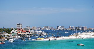
Destin is a city located in Okaloosa County, Florida, United States. It is a principal city of the Crestview–Fort Walton Beach–Destin metropolitan area.

The Florida panhandle is the northwestern part of the U.S. state of Florida. It is a salient roughly 200 miles (320 km) long, bordered by Alabama on the north and the west, Georgia on the north, and the Gulf of Mexico to the south. Its eastern boundary is arbitrarily defined. It is defined by its southern culture and rural geography relative to the rest of Florida, as well as closer cultural links to French-influenced Louisiana, Mississippi, and Alabama. Its major communities include Pensacola, Navarre, Destin, Panama City Beach, and Tallahassee.
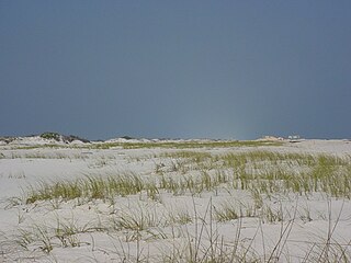
Santa Rosa Island is a 40-mile (64 km) barrier island located in the U.S. state of Florida, thirty miles (50 km) east of the Alabama state border. The communities of Pensacola Beach, Navarre Beach, and Okaloosa Island are located on the island. On the northern side of the island, are Pensacola Bay on the west and Choctawhatchee Bay on the east, joined through Santa Rosa Sound.

The Emerald Coast is an unofficial name for the coastal area in the US state of Florida on the Gulf of Mexico that stretches about 100 miles (160 km) through five counties, Escambia, Santa Rosa, Okaloosa, Walton, and Bay, which include Pensacola Beach, Navarre Beach, Fort Walton Beach, Destin, and Panama City Beach. Some south Alabama communities on the coast of Baldwin County, such as Gulf Shores, Orange Beach, and Fort Morgan embrace the term as well.

Navarre is a census-designated place and unincorporated community in Santa Rosa County in the northwest Florida Panhandle. It is a major bedroom community for mostly U.S. military personnel, federal civil servants, local population, retirees and defense contractors. Due to Navarre Beach and the 4 miles (6.4 km) of beach front on the Gulf of Mexico thereof, as well as several miles of beaches within the Navarre Beach Marine Park and the Gulf Islands National Seashore, it has a small, but rapidly growing community of nature enthusiasts and tourists. Navarre has grown from being a small town of around 1,500 in 1970 to a town with a population estimated at 43,540 as of 2020, if including both the Navarre and Navarre Beach Census Designated Places.

Gulf Islands National Seashore is an American National seashore that offers recreation opportunities and preserves natural and historic resources along the Gulf of Mexico barrier islands of Florida and Mississippi. In 2022, it was the eighth-most visited unit of the National Park Service.

Perdido Key is an unincorporated community in Escambia County, Florida located between Pensacola, Florida and Orange Beach, Alabama. The community is located on and named for Perdido Key, a barrier island in northwest Florida and southeast Alabama. "Perdido" means "lost" in the Spanish and Portuguese languages. The Florida district of the Gulf Islands National Seashore includes the east end of the island, as well as other Florida islands. No more than a few hundred yards wide in most places, Perdido Key stretches some 16 miles (26 km) from near Pensacola to Perdido Pass Bridge near Orange Beach.

The East Bay River in Florida is a 15-mile-long (24 km) river located in Santa Rosa and Okaloosa counties. It flows from east to west, forming near Hurlburt Field, and empties into the eastern portion of East Bay (Florida) near the towns Holley and Navarre. The river forms part of the southern boundary of Eglin Air Force Base.
The Fairpoint Peninsula, also referred to as the Gulf Breeze Peninsula or the Navarre Peninsula or historically the Santa Rosa Peninsula, is located in northwest Florida between Santa Rosa Sound and Pensacola Bay.

The Pensacola metropolitan area is the metropolitan area centered on Pensacola, Florida. It is also known as the Pensacola-Ferry Pass-Brent Metropolitan Statistical Area, a metropolitan statistical area (MSA) used for statistical purposes by the United States Census Bureau and other agencies. The Pensacola Standard Metropolitan Statistical Area was first defined in 1958, with Pensacola as the principal city, and included Escambia and Santa Rosa counties. The SMA was renamed Pensacola-Ferry Pass-Brent MSA in 2003, with the unincorporated census-designated places Ferry Pass and Brent added as principal cities. The population of the MSA in the 2020 census was 511,502.
The history of Pensacola, Florida, begins long before the Spanish claimed founding of the modern city in 1698. The area around present-day Pensacola was inhabited by Native American peoples thousands of years before the historical era.

East Bay is a bay located in the far western Florida Panhandle. Unusually, East Bay is connected to open waters via Pensacola Bay to its southwest. The bay is fed primarily by the Blackwater River and the East Bay River.

The Pensacola culture was a regional variation of the Mississippian culture along the Gulf Coast of the United States that lasted from 1100 to 1700 CE. The archaeological culture covers an area stretching from a transitional Pensacola/Fort Walton culture zone at Choctawhatchee Bay in Florida to the eastern side of the Mississippi River Delta near Biloxi, Mississippi, with the majority of its sites located along Mobile Bay in the Mobile-Tensaw River Delta. Sites for the culture stretched inland, north into the southern Tombigee and Alabama River valleys, as far as the vicinity of Selma, Alabama.

Tropical Depression Six caused significant flooding along the Gulf Coast of the United States, especially in the Florida Panhandle. The sixth tropical cyclone of the 1975 Atlantic hurricane season, the depression developed from a trough of low pressure in the northeastern Gulf of Mexico on July 28. The system strengthened slightly, but peaked with maximum sustained winds of 35 mph (56 km/h) – below tropical storm intensity. Early on July 29, the depression made landfall in eastern Louisiana. Once inland, the depression slowly weakened and re-curved northeastward on July 30 into Mississippi, shortly before degenerating into a remnant low pressure area. The remnants moved through northern Louisiana and Arkansas until dissipating on August 3.
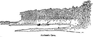
Miller Point is a small cape jutting out into East Bay on the Holley side of Navarre, Florida. Along with Axelson Point, it makes up part of the mouth of East Bay's narrow east side, called East Lagoon, which flows from the Jordan River.
Tom King Bayou is a small, but locally important, bayou and creek in Navarre, Florida. The mouth of the bayou opens onto East Bay near Axelson Point and Robledal.

Dr. Joel Rudman is an American politician and physician who currently serves as a state representative for the 3rd district in the Florida House of Representatives. Rudman resides in Navarre, his legislative district's largest community, and is a member of the Republican Party.