Podlipki is a village in the administrative district of Gmina Krynki, within Sokółka County, Podlaskie Voivodeship, in north-eastern Poland, close to the border with Belarus. It lies approximately 11 kilometres (7 mi) south-west of Krynki, 24 km (15 mi) south-east of Sokółka, and 35 km (22 mi) east of the regional capital Białystok.
Dębowiec is a village in the administrative district of Gmina Sośno, within Sępólno County, Kuyavian-Pomeranian Voivodeship, in north-central Poland. It lies approximately 3 kilometres (2 mi) south-west of Sośno, 12 km (7 mi) south-east of Sępólno Krajeńskie, and 37 km (23 mi) north-west of Bydgoszcz.
Adolfów is a village in the administrative district of Gmina Zgierz, within Zgierz County, Łódź Voivodeship, in central Poland. It lies approximately 11 kilometres (7 mi) north-west of Zgierz and 19 km (12 mi) north-west of the regional capital Łódź.
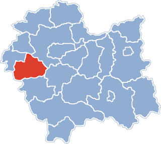
Sielec is a village in the administrative district of Gmina Wiślica, within Busko County, Świętokrzyskie Voivodeship, in south-central Poland. It lies approximately 3 kilometres (2 mi) north-west of Wiślica, 12 km (7 mi) south of Busko-Zdrój, and 58 km (36 mi) south of the regional capital Kielce.
Śmiechowice is a village in the administrative district of Gmina Samborzec, within Sandomierz County, Świętokrzyskie Voivodeship, in south-central Poland. It lies approximately 4 kilometres (2 mi) west of Samborzec, 10 km (6 mi) west of Sandomierz, and 75 km (47 mi) east of the regional capital Kielce.
Babica is a village in the administrative district of Gmina Czudec, within Strzyżów County, Subcarpathian Voivodeship, in south-eastern Poland. It lies approximately 5 kilometres (3 mi) east of Czudec, 11 km (7 mi) north-east of Strzyżów, and 14 km (9 mi) south-west of the regional capital Rzeszów.
Poręby is a village in the administrative district of Gmina Besko, within Sanok County, Podkarpackie Voivodeship, in south-eastern Poland.
Grzechynia is a village in the administrative district of Gmina Maków Podhalański, within Sucha County, Lesser Poland Voivodeship, in southern Poland. It lies approximately 3 kilometres (2 mi) south-west of Maków Podhalański, 6 km (4 mi) south-east of Sucha Beskidzka, and 44 km (27 mi) south-west of the regional capital Kraków.
Nur-Kolonia Wschodnia is a settlement in the administrative district of Gmina Nur, within Ostrów Mazowiecka County, Masovian Voivodeship, in east-central Poland.
Popowo-Ignacewo is a village in the administrative district of Gmina Mieleszyn, within Gniezno County, Greater Poland Voivodeship, in west-central Poland.
Kruszewo is a village in the administrative district of Gmina Ujście, within Piła County, Greater Poland Voivodeship, in west-central Poland.
Stary Sielec is a village in the administrative district of Gmina Jutrosin, within Rawicz County, Greater Poland Voivodeship, in west-central Poland.
Zastawie is a village in the administrative district of Gmina Słupca, within Słupca County, Greater Poland Voivodeship, in west-central Poland. It lies approximately 6 kilometres (4 mi) north-east of Słupca and 70 km (43 mi) east of the regional capital Poznań.
Dąbrowa is a village in the administrative district of Gmina Lubsko, within Żary County, Lubusz Voivodeship, in western Poland. It lies approximately 10 kilometres (6 mi) north of Lubsko, 30 km (19 mi) north-west of Żary, and 40 km (25 mi) west of Zielona Góra.
Jędrzejów is a village in the administrative district of Gmina Grodków, within Brzeg County, Opole Voivodeship, in south-western Poland. It lies approximately 5 kilometres (3 mi) south-west of Grodków, 26 km (16 mi) south-west of Brzeg, and 44 km (27 mi) west of the regional capital Opole.
Jeżewo is a village in the administrative district of Gmina Łęczyce, within Wejherowo County, Pomeranian Voivodeship, in northern Poland. It lies approximately 9 kilometres (6 mi) south-east of Łęczyce, 22 km (14 mi) west of Wejherowo, and 49 km (30 mi) west of the regional capital Gdańsk.
Poradz is a village in the administrative district of Gmina Sławoborze, within Świdwin County, West Pomeranian Voivodeship, in north-western Poland. It lies approximately 9 kilometres (6 mi) north-west of Sławoborze, 20 km (12 mi) north-west of Świdwin, and 89 km (55 mi) north-east of the regional capital Szczecin.
Miřetice is a municipality and village in Benešov District in the Central Bohemian Region of the Czech Republic.
Kara Ada or Karaada, literally 'Black Island', is the name of several small islands in Turkish.
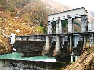
Ketto Dam is a dam in Tsunan, Niigata Prefecture, Japan, near the village of Ketto. It was completed in 1972.