Related Research Articles
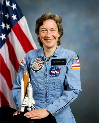
Mary Louise Cleave is an American engineer and a former NASA astronaut. She also served from 2005 to 2007 as NASA Associate Administrator for the Science Mission Directorate.
The National Snow and Ice Data Center (NSIDC) is a United States information and referral center in support of polar and cryospheric research. NSIDC archives and distributes digital and analog snow and ice data and also maintains information about snow cover, avalanches, glaciers, ice sheets, freshwater ice, sea ice, ground ice, permafrost, atmospheric ice, paleoglaciology, and ice cores.

Jason-1 was a satellite altimeter oceanography mission. It sought to monitor global ocean circulation, study the ties between the ocean and the atmosphere, improve global climate forecasts and predictions, and monitor events such as El Niño and ocean eddies. Jason-1 was launched in 2001 and it was followed by OSTM/Jason-2 in 2008, and Jason-3 in 2016 – the Jason satellite series. Jason-1 was launched alongside the TIMED spacecraft.
The Byrd Polar and Climate Research Center (BPCRC) is a polar, alpine, and climate research center at The Ohio State University founded in 1960.
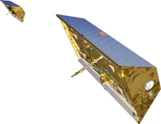
The Gravity Recovery and Climate Experiment (GRACE) was a joint mission of NASA and the German Aerospace Center (DLR). Twin satellites took detailed measurements of Earth's gravity field anomalies from its launch in March 2002 to the end of its science mission in October 2017. The two satellites were sometimes called Tom and Jerry, a nod to the famous cartoon. The GRACE Follow-On (GRACE-FO) is a continuation of the mission on near-identical hardware, launched in May 2018.
SeaWIFS was a satellite-borne sensor designed to collect global ocean biological data. Active from September 1997 to December 2010, its primary mission was to quantify chlorophyll produced by marine phytoplankton.

TOPEX/Poseidon was a joint satellite altimeter mission between NASA, the U.S. space agency; and CNES, the French space agency, to map ocean surface topography. Launched on August 10, 1992, it was the first major oceanographic research satellite. TOPEX/Poseidon helped revolutionize oceanography by providing data previously impossible to obtain. Oceanographer Walter Munk described TOPEX/Poseidon as "the most successful ocean experiment of all time." A malfunction ended normal satellite operations in January 2006.

GeoEye Inc. was an American commercial satellite imagery company based in Herndon, Virginia. GeoEye was merged into the DigitalGlobe corporation on January 29, 2013.

Ocean color is the branch of ocean optics that specifically studies the color of the water and information that can be gained from looking at variations in color. The color of the ocean, while mainly blue, actually varies from blue to green or even yellow, brown or red in some cases. This field of study developed alongside water remote sensing, so it is focused mainly on how color is measured by instruments.

OSTM/Jason-2, or Ocean Surface Topography Mission/Jason-2 satellite, was an international Earth observation satellite altimeter joint mission for sea surface height measurements between NASA and CNES. It was the third satellite in a series started in 1992 by the NASA/CNES TOPEX/Poseidon mission and continued by the NASA/CNES Jason-1 mission launched in 2001.
Gene Carl Feldman has been an oceanographer at NASA Goddard Space Flight Center (GSFC) since 1985. His primary interest has been to try to make the data that NASA gathers from its spaceborne fleet of Earth observing instruments, especially those monitoring the subtle changes in ocean color, as scientifically credible, readily understandable and as easily available to the broadest group of people possible. He has been involved in a number of past and present NASA missions including the Coastal Zone Color Scanner (CZCS), the Sea-Viewing Wide Field Sensor (SeaWiFS) and the Moderate-Resolution Imaging Spectroradiometer (MODIS) and along with the NASA Ocean Biology Processing group which he co-leads, been given the responsibility for designing, implementing and operating the data processing and mission operations component of ocean salinity mission called Aquarius, a space mission developed by NASA and the Space Agency of Argentina - Comisión Nacional de Actividades Espaciales (CONAE) that was successfully launched in June 2011 and began routine operations on December 1, 2011 and completed its prime mission in June 2015.

Eric J. Rignot is the Donald Bren, Distinguished and Chancellor Professor of Earth system science at the University of California, Irvine, and a Senior Research Scientist for the Radar Science and Engineering Section at NASA's Jet Propulsion Laboratory. He studies the interaction of the polar ice sheets in Greenland and Antarctica with global climate using a combination of satellite remote sensing, airborne remote sensing, understanding of physical processes controlling glacier flow and ice melt in the ocean, field methods, and climate modeling. He was elected at the National_Academy_of_Sciences in 2018.
Astrobiology Science and Technology for Exploring Planets (ASTEP) was a program established by NASA to sponsor research projects that advance the technology and techniques used in planetary exploration. The objective was to enable the study of astrobiology and to aid the planning of extraterrestrial exploration missions while prioritizing science, technology, and field campaigns.
W. Timothy Liu is an American meteorologists and atmospheric scientist. He became a Fellow of the American Meteorological Society in the year 2000, a Fellow of American Association for the Advancement of Science in 2007, and most recently an American Geophysical Union Fellow (2011). By the end of 2008 he had published 145 refereed journal articles or reviewed book chapters, and has authored over 260 publications in total.

PhoneSat is an ongoing NASA project of building nanosatellites using unmodified consumer-grade off-the-shelf smartphones and Arduino platform and launching them into Low Earth Orbit. This project is part of NASA's Small Spacecraft Technology Program and was started in 2009 at NASA Ames Research Center.
George Henry Born was an American aerospace engineer, Distinguished Professor, founder and Director Emeritus of the Colorado Center for Astrodynamics Research (CCAR) at the University of Colorado Boulder. He is known for his work in satellite navigation and precise orbit determination. He worked on various missions while at the Jet Propulsion Laboratory as well as navigation support for the Apollo program in the late 1960s while at Johnson Space Center.
Paula Susan Bontempi is an oceanographer who has led the use of satellites in marine science during her positions in NASA and as the dean of the Graduate School of Oceanography at the University of Rhode Island.

The SeaWiFS Bio-optical Archive and Storage System (SeaBASS) is a data archive of in situ oceanographic data used to support satellite remote sensing research of ocean color. SeaBASS is used for developing algorithms for satellite-derived variables and for validating or “ground-truthing” satellite-derived data products. The acronym begins with “S” for SeaWiFS, because the data repository began in the 1990s around the time of the launch of the SeaWiFS satellite sensor, and the same data archive has been used ever since. Oceanography projects funded by the NASA Earth Science program are required to upload data collected on research campaigns to the SeaBASS data repository to increase the volume of open-access data available to the public. As of 2021 the data archive contained information from thousands of field campaigns uploaded by over 100 principal investigators.
Karen E. Frey is an American Earth scientist at Clark University whose research interests involve the combined use of field measurements, satellite remote sensing, and geospatial analytics to study large-scale linkages between land, atmosphere, ocean, and ice in polar environments. Since 1999, she has conducted field-based research in West and East Siberia, the North Slope of Alaska, as well as the Bering, Chukchi, and Beaufort Seas. Her most recent work focuses on the biological and biogeochemical impacts of sea ice decline in polar shelf environments as well as the hydrological and biogeochemical impacts of terrestrial permafrost degradation across the Arctic.
References
- ↑ Krauss, Clifford (March 7, 2007). "Green Gold or Just Slime?". The New York Times.
- 1 2 "profile page". Archived from the original on 2010-08-28.
- ↑ "What to Expect from the Arctic". What on Earth. Archived from the original on 2010-06-28.