
Rio Grande do Sul is a state in the southern region of Brazil. It is the fifth-most populous state and the ninth-largest by area. Located in the southernmost part of the country, Rio Grande do Sul is bordered clockwise by Santa Catarina to the north and northeast, the Atlantic Ocean to the east, the Uruguayan departments of Rocha, Treinta y Tres, Cerro Largo, Rivera, and Artigas to the south and southwest, and the Argentine provinces of Corrientes and Misiones to the west and northwest. The capital and largest city is Porto Alegre. The state has the highest life expectancy in Brazil, and the crime rate is relatively low compared to the Brazilian national average. Despite the high standard of living, unemployment is still high in the state, as of 2017. The state has 5.4% of the Brazilian population and it is responsible for 6.6% of the Brazilian GDP.
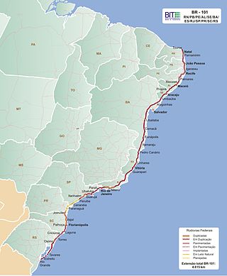
The BR-101 is a longitudinal highway of Brazil. It is the longest in the country with a length of nearly 4,800 km (3,000 mi), and it is considered one of the most important highways in the country, along with BR-116.

The Brazilian Highway System is a network of trunk roads administered by the Ministry of Transport of Brazil. It is constructed, managed and maintained by the National Department of Transport Infrastructure (DNIT), federal agency linked to the Ministry of Infrastructure, and the public works departments of state governments.

Soledade is a municipality in Rio Grande do Sul, Brazil. The city is nicknamed the Cidade das Pedras Preciosas meaning the City of Precious Stones or Rare Gems. Much of the amethyst sold in the world comes from the mines of Rio Grande do Sul near Soledade. Most of the factories in Soledade process and sell these stones internationally. As of 2020, the estimated population was 31,035.
Frederico Westphalen is a southern Brazilian town located in the state of Rio Grande do Sul.

BR-163 is a highway in Brazil, going from Tenente Portela, in the state of Rio Grande do Sul, to Santarém, Pará, on 3579 kilometers. It was proposed to pave the road in its entirety part of the Avança Brasil project, which in 2007 was replaced by the Programa de Aceleração do Crescimento. A 51 km long stretch of the highway was finally paved in 2019 in the state of Pará in a cooperation between the Bolsonaro government and the Brazilian army engineering battalion, until the city of Miritituba, leaving only a small part of the highway to be paved on the other side of the Amazon River.

BR-262 is an east-west highway connecting the Brazilian states of Espírito Santo, Minas Gerais, São Paulo and Mato Grosso do Sul.

Não-Me-Toque is a Brazilian municipality located in the state of Rio Grande do Sul.
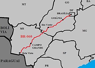
BR-060 is a federal highway of Brazil. The 1329 kilometre road connects Brasília to Bela Vista, on the Paraguayan border.
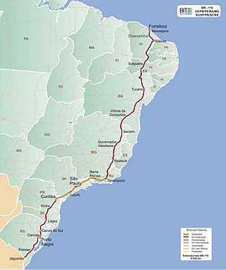
BR-116 is a federal route of highways of Brazil and the longest highway in the country, with 4,542 km (2,822 mi) of extension. The road connect Fortaleza, Ceará, one of the largest Northeast Brazil metropolises, to the southern city of Jaguarão, Rio Grande do Sul, in the border with Uruguay. It is also the longest highway in the country to be completely paved. It is considered one of the most important highways in the country, along with BR-101.
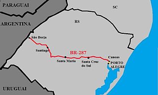
The BR-287 is a 536.9 km-long federal highway across the Brazilian state of Rio Grande do Sul, also known as the Highway of Integration.

The BR-290 is an important highway in the Rio Grande do Sul state of Brazil. Approximately 726km long, the highway runs from the port city of Osório westward to the city of Uruguaiana, on the border of Argentina.

A BR-377 is an diagonal federal highway in Rio Grande do Sul, Brazil. It connects the city of Carazinho to the border with Uruguay, in the Brazilian city of Quaraí.
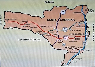
BR-282 is a federal highway in the southern Brazilian state of Santa Catarina. The highway goes the entire length of the state from the state capital, Florianópolis on the Atlantic Ocean in the east, 680.6 km westward to the town of Paraíso on the border with Argentina.

BR-392 is a federal highway in Rio Grande do Sul. The highway begins at the port town of Rio Grande in the south and runs north across the state, connecting the municipalities of Pelotas, Santa Maria, Santo Ângelo, and ending in Porto Xavier at the border with Argentina.
BR-470 is an east-west Brazilian federal highway that starts in Navegantes, Santa Catarina, and crosses the Gaucho range and highlands. It stretches approximately 833 km, passing through cities such as Itajaí, Blumenau, Rio do Sul, Curitibanos, Campos Novos, Bento Gonçalves, Veranópolis and Montenegro and ends in Camaquã, Rio Grande do Sul.
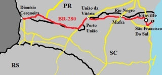
The BR-280 is a Brazilian federal highway that connects the cities of São Francisco do Sul, in the state of Santa Catarina, to Dionísio Cerqueira, Santa Catarina. It has a total length of 642.2 km.

The BR-471 is a Brazilian federal highway that connects the cities of Soledade and Chuí, in the state of Rio Grande do Sul. It has a total length of 648.2 km.


