Baarnse Bos

Last updated
An avenue with beach trees in the Baarnsche Bos Baarnsche bos.jpg
An avenue with beach trees in the Baarnsche Bos

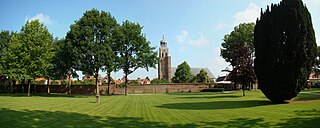
The Baarnse Bos is a park/forest in the southern part of the municipality of Baarn, the province of Utrecht (province), the Netherlands. The area of the forest if approximately 80 hectares (200 acres) and is adjacent to the Soestdijk Palace. [1]

Baarn Municipality in Utrecht, Netherlands

Baarn[baːrn](listen) is a municipality and a town in the Netherlands, in the province of Utrecht.

Utrecht (province) Province of the Netherlands

Utrecht is a province of the Netherlands. It is located in the centre of the country, bordering the Eemmeer in the north-east, the province of Gelderland in the east and south-east, the province of South Holland in the west and south-west and the province of North Holland in the north-west and north. With an area of approximately 1,400 square kilometres (540 sq mi), it is the smallest of the twelve Dutch provinces. Apart from its eponymous capital, major cities in the province are Amersfoort, Houten, Nieuwegein, Veenendaal, IJsselstein and Zeist.

Soestdijk Palace palace

Soestdijk Palace is a former palace of the Dutch Royal Family. It consists of a central block and two wings.

The forest is limited by Amsterdamse Straatweg (N221) in the west, Lt. Generaal van Heutszlaan in the north, the railway connecting Amsterdam and Amersfoot, as well as Torenlaan in the east, and Praamgracht in the south. [2] The Soestdijk Palace is across Amsterdamse Straatweg, and the Baarnse Bos continues across this road as a large forest reaching Hilversum in the west.

Hilversum City and municipality in North Holland, Netherlands

Hilversum is a city and municipality in the province of North Holland, Netherlands. Located in the heart of the Gooi, it is the largest urban centre in that area. It is surrounded by heathland, woods, meadows, lakes, and smaller towns. Hilversum is part of the Randstad, one of the largest conurbations in Europe.

The Baarnse Bos was designed as a French landscape garden between 1733 and 1758. At the time, it was built around the land estate De Eult. In 1758, the estate, together with the forest, was transferred to the Dutch royal family. Since the end of the 19th century, it has been accessible for general public. [1] [3]

French landscape garden

The French landscape garden is a style of garden inspired by idealized romantic landscapes and the paintings of Hubert Robert, Claude Lorrain and Nicolas Poussin, European ideas about Chinese gardens, and the philosophy of Jean-Jacques Rousseau. The style originated in England, as the "English landscape garden", in the early 18th century and spread to France, where, in the late 18th and early 19th century, it gradually replaced the symmetrical French formal garden.

Monarchy of the Netherlands Wikimedia list article

The monarchy of the Netherlands is constitutional and, as such, the role and position of the monarch are defined and limited by the Constitution of the Netherlands. Consequently, a fairly large portion of the Dutch Constitution is devoted to the monarch; roughly a third of the document describes the succession, mechanisms of accession and abdication to the throne, the roles and responsibilities of the monarch and the formalities of communication between the Staten-Generaal and the role of the monarch in the creation of laws.

Related Research Articles

Doorn farm village in the Netherlands

Doorn is a town in the municipality of Utrechtse Heuvelrug in the central Netherlands, in the province of Utrecht. On 1 January 2017, the town had 10,067 inhabitants.

Soest, Netherlands Municipality in Utrecht, Netherlands

Soest[sust](listen) is a municipality and a town in the central Netherlands, in the province of Utrecht. It is about 6 km (4 mi) west of Amersfoort.

Amstelveen Municipality in North Holland, Netherlands

Amstelveen is a municipality in the province of North Holland, Netherlands with a population of 89,918 (2017). It is a suburban part of the metropolitan area of Amsterdam.

Amsterdam–Rhine Canal canal in the Netherlands

The Amsterdam–Rhine Canal is a canal in the Netherlands that was built to connect the port and capital city of Amsterdam to the main shipping artery of the Rhine. Its course follows a generally southeasterly direction as it goes through the city of Utrecht towards Wijk bij Duurstede where it intersects the Lek branch of the Rhine and then continues on to the river Waal near Tiel, with a branch, the Lek Canal, to the Lek near Nieuwegein.

Vollenhove City in Overijssel, Netherlands

Vollenhove is a city in the Dutch province of Overijssel. It is located in the municipality of Steenwijkerland, southwest of Steenwijk. Until the Noordoostpolder was drained, it was located on the coast of the Zuiderzee.

Vecht (Utrecht) river in the Netherlands

The Vecht is a Rhine branch in the Dutch province of Utrecht. It is sometimes called Utrechtse Vecht to avoid confusion with its Overijssel counterpart. The area along the river is called the Vechtstreek.

Bosbaan rowing venue situated in the Amsterdamse Bos

The Bosbaan is a rowing lake situated in the Amsterdamse Bos in Amstelveen, Netherlands. Amstelveen is a municipality and a town in the Netherlands and is part of the metropolitan area of Amsterdam. Confusingly, all built structures at the north-eastern end of the course fall under jurisdiction of the city of Amsterdam. The Bosbaan is the oldest artificial rowing course in the world.

Haagse Bos

Haagse Bos is a rectangular neighbourhood and forest in the Haagse Hout district of The Hague, Netherlands, reaching from the old city centre in the south-west to the border of Wassenaar in the north-east. It is also one of the oldest remaining forests of the country. During World War II, the park was used by the Germans for launching V-1 and V-2 rockets.

Berg en Bos is a residential area on a former farm in the Dutch city of Apeldoorn. In this part are Park Berg en Bos with Apenheul and Sportpark Berg en Bos.

Beerschoten is a hamlet in the municipality Utrechtse Heuvelrug, in the Dutch province Utrecht.

Bosch en Duin is a village in Zeist municipality, in the Dutch province of Utrecht. The village is located north of the town of Zeist, and borders Huis ter Heide to the east and Den Dolder to the north. It had 2,540 inhabitants (2006). The village is entirely made up of expensive estates surrounded by forest.

Den Dolder–Baarn railway

The Den Dolder–Baarn railway is a railway line in the province of Utrecht, Netherlands running from Den Dolder to Baarn, passing through Soest. It is also called the Sticht Line. Openend in 1898 in order to link Baarn with the city of Utrecht, it is operated by Nederlandse Spoorwegen and belongs to ProRail.

Amsterdamse Bos Park in the Netherlands

The Amsterdamse Bos is an English park or landscape park in the municipalities of Amstelveen and Amsterdam. Although most of the park is located in Amstelveen, the owner of the park is the City of Amsterdam. The park was mainly built in the early 1930s, mostly by the unemployment relief. Because of World War II interrupting the building process, the last tree was not planted until the 1970s. Annually, almost 4.5 million people visit the park, which has a size of 1,000 hectares and is approximately three times the size of Central Park in New York City. In it, one can find animal parks, several sporting clubs, a rowing course, gardens and remembrance monuments.

Hofvijver pond in The Hague, Netherlands

The Hofvijver is a pond in the centre of The Hague, Netherlands. It is adjoined in the east by the Korte Vijverberg (road), in the south by the Binnenhof and the Mauritshuis, in the west by the Buitenhof and in the north by the Lange Vijverberg (road). In the middle there is a small island with plants and trees which has no name, it is usually referred to as "the island in the Vijverberg".

<i>Koningsdag</i> Dutch national holiday

Koningsdag or King's Day is a national holiday in the Kingdom of the Netherlands. Celebrated on 27 April, the date marks the birth of King Willem-Alexander. Until the abdication of Queen Beatrix in 2013, the holiday was known as Koninginnedag or Queen's Day and was celebrated on 30 April.

Zuideramstel was from 1998 to 2010 a borough (stadsdeel) of Amsterdam, Netherlands. On 1 May 2010 it became part of the new Amsterdam Zuid borough.

<i>The Arrival of Cornelis de Graeff and Members of His Family at Soestdijk, His Country Estate</i> painting by Jacob van Ruisdael

The Arrival of Cornelis de Graeff and Members of His Family at Soestdijk, His Country Estate is an oil on canvas painting by the Dutch Golden Age painters Thomas de Keyser and Jacob van Ruisdael. It is in the collection of the National Gallery of Ireland in Dublin.

References

  1. 1 2 "Erfgoedparels" (in Dutch). Province of Utrecht. Retrieved 12 September 2016.
  2. "Baarnse Bos" (in Dutch). Instituut voor natuureducatie en duurzaamheid. Retrieved 14 September 2016.
  3. "Baarnse Bos" (in Dutch). Staatsbosbeheer . Retrieved 13 September 2016.

Coordinates: 52°12′36″N5°16′57″E / 52.2101°N 5.2825°E / 52.2101; 5.2825

Geographic coordinate system Coordinate system

A geographic coordinate system is a coordinate system that enables every location on Earth to be specified by a set of numbers, letters or symbols. The coordinates are often chosen such that one of the numbers represents a vertical position and two or three of the numbers represent a horizontal position; alternatively, a geographic position may be expressed in a combined three-dimensional Cartesian vector. A common choice of coordinates is latitude, longitude and elevation. To specify a location on a plane requires a map projection.