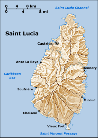
Saint Lucia is a constitutional monarchy and an island country of the West Indies in the eastern Caribbean. The island was previously called Iouanalao and later Hewanorra, names given by the native Arawaks and Caribs (respectively), two Amerindian peoples. Part of the Windward Islands of the Lesser Antilles, it is located north/northeast of the island of Saint Vincent, northwest of Barbados and south of Martinique. It covers a land area of 617 km2 with an estimated population of over 180,000 people as of 2022. The nation's capital and largest city is Castries.
Saint Lucia is one of many small land masses composing the insular group known as the Windward Islands. Unlike large limestone areas such as Florida, Cuba, and the Yucatan Peninsula, or the Bahamas, which is a small island group composed of coral and sand, St. Lucia is a typical Windward Island formation of volcanic rock that came into existence long after much of the region had already been formed.

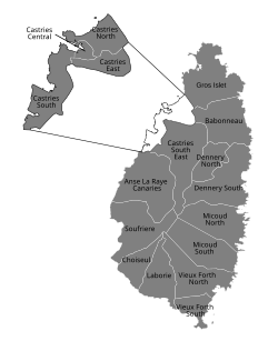
Gros Islet District, one of 10 first order subdivision of the Caribbean island nation of Saint Lucia which includes the island's northernmost point, Cap Point and the notable Cap Estate, where the renowned St. Lucia Golf and Country Club is located. Whilst the town of Gros Islet is an important administrative centre, Rodney Bay is the main financial center of the district.

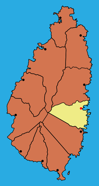
Dennery District is one of 10 districts of the Caribbean island nation of Saint Lucia. The seat of Dennery District is the Dennery Village. The main economic activities are fishing, and the cultivation of lima beans, bananas, and other tropical fruit. The population of the quarter was estimated at 12,876 in 2002 and fell to 12,767 in 2010.
Anse la Raye District is one of 10 districts of the island nation of St. Lucia in the Caribbean Sea. The name Anse la Raye is French for cover/bay of the rays, since there are a large number of skate fish or rays in the bay. In 2005/2010, the population of the district was 6,382/6,060 people, and they are mainly fishers and agricultural workers. The main town in the area takes the same name as the district and is located down the western coast from Castries, the capital of the country.

The Pitons are two mountainous volcanic plugs, volcanic spires, located in Saint Lucia. Gros Piton is 798.25 m (2,618.9 ft) high and Petit Piton is 743 m (2,438 ft) high; they are linked by the Piton Mitan ridge. The Pitons are a World Heritage Site, 2,909 ha in size, and located near the town of Soufrière.
Cap Point (French Pointe du Cap) is the northernmost point in Saint Lucia in the Caribbean. It is located in Gros Islet District on the Cap Estate/Upper Saline Point.
Choiseul District is one of the 10 districts of the Caribbean island nation of Saint Lucia. Located on the southwestern side of the island, the district is home to 6,130 people, according to the 2019 census. The seat of Choiseul District is the town of Choiseul.
Dauphin was a Quarter on the Caribbean island nation of Saint Lucia. The district was merged with Gros-Islet in 2014. It contains a village of the same name, located at 14°02′N60°54′W. It was home to Amerindians, the Island Caribs, who settled there. To this day, there are ruins which serve as a reminder of people who lived there long before Christopher Columbus crossed the Atlantic from Europe.
Micoud District is one of 10 districts of the Caribbean island nation of Saint Lucia The seat of this district is the town of Micoud inside this district. According to the 2002 census, the population of the district was 16,143 people. The final 2010 Census recorded a population of 16,284 in Micoud District. A former quarter, Praslin Quarter, was merged into Micoud Quarter. It was not enumerated separately in the 2010 Census. The 2001 Census shows Praslin as part of Micoud District.
Praslin Quarter was a former quarter on the island nation of Saint Lucia. Since at least 2001, it has been a second-order subdivision of the Micoud District. The 2001 and 2010 Census show Praslin as part of the Micoud District. The population of Praslin is 341.

The Roman Catholic Archdiocese of Castries is an archdiocese of the Latin Church of the Roman Catholic Church in the Caribbean. The archdiocese consists of the entirety of the former British dependency of Saint Lucia and is a metropolitan see, the suffragans of the Castries Province being the Dioceses of Roseau, Saint George's in Grenada, St. John's-Basseterre and Kingstown. The archdiocese is a member of the Antilles Episcopal Conference.

Pigeon Island is a 44-acre (180,000 m2) islet located in Gros Islet in the northern region of Saint Lucia. Once isolated from the country in the Caribbean Sea, the island was artificially joined to the western coast of mainland in 1972 by a man-made causeway built from dirt excavated to form the Rodney Bay Marina. Composed of two peaks the island is a historic site with numerous forts such as an 18th-century British fort and Fort Rodney both used by the British to spy on French Ships from neighbouring Martinique. In 1979 it was named a national park and again in 1992 it became a national landmark under the control of the Saint Lucia National Trust (SLNT). Today, Pigeon Island is the home and major venue of the Saint Lucia Jazz Festival.

Saint Lucia, an island nation in the Caribbean islands, has a relatively large tourism industry. Due to the relatively small land area of the country, most of the governmental promotion is performed by the state-operated Saint Lucia Tourism Authority, led by Executive Chairperson Agnes.

The Roseau Valley is a second-order subdivision in the island nation of St. Lucia. It is home to the island's largest banana plantation. The 2010 population of the Roseau Valley was 227.

Monchy is a town and second-order administrative division of Gros Islet District in the island nation of Saint Lucia. The town is located near the northern end of the island about 4 kilometres (2.5 mi) from Gros Islet, and about 7.9 kilometres (4.9 mi) from the capital, Castries.
La Tourney is a town in Vieux Fort District in the island country of Saint Lucia. La Tourney is in the La Tourney/Cedar Heights section of Vieux Fort District, which has a population of 706. La Tourney is located on the southern coast of Saint Lucia, close to Hewanorra International Airport. There is also a 127 m (417 ft) high Tourney Mountain nearby at 13°44′34″N60°57′55″W.

Soufrière is a town on the West Coast of Saint Lucia, in the eastern Caribbean Sea. The town and the surrounding district has a population of 7,935. It was colonized by the French and was the original capital of the island.
The 2019 SLFA Island Cup was an association football cup competition for the island of Saint Lucia. The tournament began on 2 July 2019 and concluded on 21 December 2019.
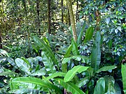 Foliage near Babonneau
 Trees of Babonneau