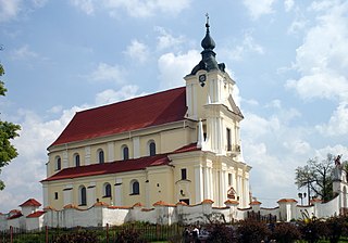
Siemiatycze is a town in north-eastern Poland, with 15,209 inhabitants (2004). It is situated in the Podlaskie Voivodeship ; previously it was in Białystok Voivodeship (1975–98). It is the capital of Siemiatycze County.

Chutkowice is a village in the administrative district of Gmina Drohiczyn, within Siemiatycze County, Podlaskie Voivodeship, in north-eastern Poland. It lies approximately 8 kilometres (5 mi) north-west of Drohiczyn, 21 km (13 mi) west of Siemiatycze, and 85 km (53 mi) south-west of the regional capital Białystok.

Lisowo is a village in the administrative district of Gmina Drohiczyn, within Siemiatycze County, Podlaskie Voivodeship, in north-eastern Poland. It lies approximately 6 kilometres (4 mi) north of Drohiczyn, 17 km (11 mi) west of Siemiatycze, and 83 km (52 mi) south-west of the regional capital Białystok.

Dziadkowice is a village in Siemiatycze County, Podlaskie Voivodeship, in north-eastern Poland. It is the seat of the gmina called Gmina Dziadkowice. It lies approximately 14 kilometres (9 mi) north of Siemiatycze and 66 km (41 mi) south of the regional capital Białystok.

Augustynka is a village in the administrative district of Gmina Nurzec-Stacja, within Siemiatycze County, Podlaskie Voivodeship, in north-eastern Poland, close to the border with Belarus. It lies approximately 5 kilometres (3 mi) east of Nurzec-Stacja, 20 km (12 mi) east of Siemiatycze, and 74 km (46 mi) south of the regional capital Białystok.

Wólka Nurzecka is a village in the administrative district of Gmina Nurzec-Stacja, within Siemiatycze County, Podlaskie Voivodeship, in north-eastern Poland, close to the border with Belarus. It lies approximately 12 kilometres (7 mi) east of Nurzec-Stacja, 27 km (17 mi) east of Siemiatycze, and 75 km (47 mi) south of the regional capital Białystok.

Baciki Bliższe is a village in the administrative district of Gmina Siemiatycze, within Siemiatycze County, Podlaskie Voivodeship, in north-eastern Poland. It lies approximately 5 kilometres (3 mi) north-east of Siemiatycze and 76 km (47 mi) south of the regional capital Białystok.

Baciki Dalsze is a village in the administrative district of Gmina Siemiatycze, within Siemiatycze County, Podlaskie Voivodeship, in north-eastern Poland. It lies approximately 6 kilometres (4 mi) north-east of Siemiatycze and 75 km (47 mi) south of the regional capital Białystok.

Cecele is a village in the administrative district of Gmina Siemiatycze, within Siemiatycze County, Podlaskie Voivodeship, in north-eastern Poland. It lies approximately 8 kilometres (5 mi) north-west of Siemiatycze and 77 km (48 mi) south of the regional capital Białystok.

Czartajew is a village in the administrative district of Gmina Siemiatycze, within Siemiatycze County, Podlaskie Voivodeship, in north-eastern Poland. It lies approximately 5 kilometres (3 mi) north-west of Siemiatycze and 76 km (47 mi) south of the regional capital Białystok.

Kłopoty-Stanisławy is a village in north-eastern Poland, located in the administrative district of Gmina Siemiatycze, within Siemiatycze County, Podlaskie Voivodeship. It lies approximately 11 kilometres (7 mi) north-west of Siemiatycze and 72 km (45 mi) south of the regional capital Białystok.

Korzeniówka Duża is a village in the administrative district of Gmina Siemiatycze, within Siemiatycze County, Podlaskie Voivodeship, in north-eastern Poland. It lies approximately 9 kilometres (6 mi) north-west of Siemiatycze and 79 km (49 mi) south of the regional capital Białystok.

Krasewicze-Jagiełki is a village in the administrative district of Gmina Siemiatycze, within Siemiatycze County, Podlaskie Voivodeship, in north-eastern Poland. It lies approximately 8 kilometres (5 mi) north-west of Siemiatycze and 75 km (47 mi) south of the regional capital Białystok.

Leszczka is a village in the administrative district of Gmina Siemiatycze, within Siemiatycze County, Podlaskie Voivodeship, in north-eastern Poland. It lies approximately 7 kilometres (4 mi) north of Siemiatycze and 73 km (45 mi) south of the regional capital Białystok.

Rogawka is a village in the administrative district of Gmina Siemiatycze, within Siemiatycze County, Podlaskie Voivodeship, in north-eastern Poland. It lies approximately 5 kilometres (3 mi) west of Siemiatycze and 80 km (50 mi) south of the regional capital Białystok.

Romanówka is a village in the administrative district of Gmina Siemiatycze, within Siemiatycze County, Podlaskie Voivodeship, in north-eastern Poland. It lies approximately 8 kilometres (5 mi) north-east of Siemiatycze and 73 km (45 mi) south of the regional capital Białystok.

Stare Krasewicze is a village in the administrative district of Gmina Siemiatycze, within Siemiatycze County, Podlaskie Voivodeship, in north-eastern Poland. It lies approximately 7 kilometres (4 mi) north-west of Siemiatycze and 75 km (47 mi) south of the regional capital Białystok.

Tołwin is a village in the administrative district of Gmina Siemiatycze, within Siemiatycze County, Podlaskie Voivodeship, in north-eastern Poland. It lies approximately 11 kilometres (7 mi) north-east of Siemiatycze and 70 km (43 mi) south of the regional capital Białystok.

Wiercień Mały is a village in the administrative district of Gmina Siemiatycze, within Siemiatycze County, Podlaskie Voivodeship, in north-eastern Poland. It lies approximately 8 kilometres (5 mi) north of Siemiatycze and 72 km (45 mi) south of the regional capital Białystok.

Wyromiejki is a village in the administrative district of Gmina Siemiatycze, within Siemiatycze County, Podlaskie Voivodeship, in north-eastern Poland. It lies approximately 7 kilometres (4 mi) north of Siemiatycze and 74 km (46 mi) south of the regional capital Białystok.


