
Trout Lake Township is located in north central Minnesota in Itasca County, United States. It is bordered by the City of Coleraine to the west and north, City of Bovey on the north, an unorganized township on the east, and Blackberry Township to the south. Town government was adopted on March 6, 1894. The population was 1,056 at the 2020 census.

The Deschutes River in central Oregon is a major tributary of the Columbia River. The river provides much of the drainage on the eastern side of the Cascade Range in Oregon, gathering many of the tributaries that descend from the drier, eastern flank of the mountains. The Deschutes provided an important route to and from the Columbia for Native Americans for thousands of years, and then in the 19th century for pioneers on the Oregon Trail. The river flows mostly through rugged and arid country, and its valley provides a cultural heart for central Oregon. Today the river supplies water for irrigation and is popular in the summer for whitewater rafting and fishing.

The Chequamegon–Nicolet National Forest is a 1,530,647-acre (6,194.31 km2) U.S. National Forest in northern Wisconsin in the United States. Due to logging in the early part of the 20th century, very little old growth forest remains. Some of the trees there were planted by the Civilian Conservation Corps in the 1930s. The national forest land trees and vegetation are part of the North Woods Ecoregion that prevails throughout the upper Great Lakes region.

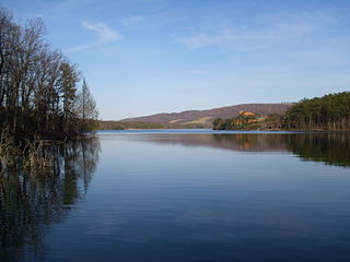
Lake Vermilion is a shallow freshwater lake in northeastern Minnesota, United States. The Ojibwe originally called the lake Onamanii-zaaga'iganiing, which means “the evening sun tinting the water a reddish color”. French fur traders translated this to the Latin word Vermilion, which is a red pigment. Lake Vermilion is located between the towns of Tower on the east and Cook on the west, in the heart of Minnesota's Arrowhead Region at Vermilion Iron Range. The area was mined from the late 19th century until the 1960s, and the Soudan Mine operated just south of the lake.

Glacial Lakes State Park is a state park of Minnesota, USA, approximately 5 miles (8.0 km) south of Starbuck. It was founded in 1963 to preserve some of the remaining rolling prairie which previously covered much of the state. Located in the Leaf Mountains, the park and the area around it contains many glacial landforms created by the Wisconsonian glaciation.

Torch Lake is a lake in the Northern Lower Peninsula of the U.S. state of Michigan. At 19 miles (31 km) long, is Michigan's longest inland lake, and at approximately 29.3 mi2 (76 km2), it is Michigan's second largest inland lake, after Houghton Lake. It has a maximum depth of 310 feet (94 m) and an average depth of 111 feet (34 m), making it Michigan's deepest inland lake, as well as the state's largest by volume.
Rocky Gap State Park is a public recreation area with resort features located on Interstate 68, seven miles (11 km) east of Cumberland in Allegany County, Maryland. The state park's 3,000 acres (1,200 ha) include Lake Habeeb, Evitts Mountain, and the privately owned and operated Rocky Gap Casino Resort. The park offers water recreation, camping facilities, and hiking trails. The park is managed by the Maryland Department of Natural Resources, the resort by Golden Entertainment, Inc.

Red Lake is a lake in Beltrami County in northern Minnesota.

Des Plaines Fish and Wildlife Area is an Illinois state park on 5,000 acres (2,023 ha) in Will County, Illinois, United States. It is located on floodplain adjacent to the confluence of the Des Plaines River and the Kankakee River to form the Illinois River.

The natural history of Minnesota covers the plant and animal species of the U.S. state of Minnesota. The continental climate and location of Minnesota at the physiographic intersection of the Laurentian and the Interior Plains influences its plant and animal life. Three of North America's biomes converge in Minnesota: prairie grasslands in the southwestern and western parts of the state, the eastern temperate deciduous forests in the east-central and the southeast, and the coniferous forest in the north-central and northeast.
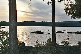
Burntside Lake is a 7,139-acre (28.89 km2) lake, located 3 miles (4.8 km) northwest of Ely, Minnesota, in Saint Louis County, Minnesota. Its western boundary adjoins the Boundary Waters Canoe Area Wilderness on Tamarack Creek.

Gull Lake is a lake in the U.S. state of Minnesota, located in Cass County and Crow Wing County. It is one of the largest lakes in the Brainerd, Minnesota-Baxter, Minnesota area and also one of the most popular for vacationing and for recreation. Of the seven Gull Lakes in Minnesota, this Gull Lake is the largest in area and shoreline. The shoreline is highly developed with residential and commercial interests. For each shoreline mile there are 27.8 homes or cabins. There are 19 resorts on Gull Lake, including notably Cragun's, Madden's, and Grand View Lodge.
Woodrum Lake Wildlife Management Area, is located about 3 miles (4.8 km) east of Romance, West Virginia in Jackson County. Woodrum Lake WMA is located on 1,696 acres (686 ha) of hilly oak-hickory hardwood lots mixed with abandoned farmland.

Greenleaf Lake State Recreation Area is a state park unit of Minnesota, USA, currently in development. It includes undeveloped shoreline on both Greenleaf and Sioux Lakes, halfway between the cities of Hutchinson and Litchfield in Meeker County. Portions of the state recreation area (SRA) are open to the public for day-use recreation, but there are no facilities yet on site. The park boundaries were set by the Minnesota Legislature and the state is still acquiring land from willing sellers; two-thirds of the property remain privately owned.
Lake Moraine is a mesotrophic lake located 2.5 miles (4.0 km) northeast of Hamilton, New York. The lake is 261 acres (1.06 km2), consisting of two basins which are separated by a causeway and interconnected by a culvert. The northern basin is 79 acres (0.32 km2) and is relatively shallow with a maximum depth of 12 feet (3.7 m) and average depth of 3.7 feet (1.1 m). The larger southern basin is 172 acres (0.70 km2) and has a maximum depth of 45 feet (14 m) and an average depth of 17.7 feet (5.4 m). Payne Brook is the lake's outflow that flows into the Chenango River.

The Southern Unit of the Kettle Moraine State Forest includes more than 22,000 acres of land throughout southern Wisconsin and spans several state parks and natural areas. The area also features varied environments from restored prairie, forests, and lakes, along with providing a multitude of recreational opportunities such as hiking, birdwatching, fishing, camping, and hunting. The Kettle Moraine Scenic Drive also extends within this region as well as through a larger portion of the state.
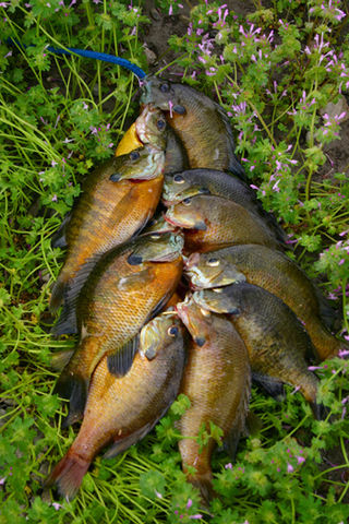
Fence Lake is a 3,483 acre lake in Vilas County, Wisconsin. The communities of Marlands and Lac du Flambeau border the lake. The fish present in the lake are Muskellunge, Panfish, Largemouth Bass, Smallmouth Bass, Northern Pike, Trout and Walleye.
Fox Lake is a 2,713 acre lake in Dodge County, Wisconsin. The City of Fox Lake, and the communities of Lyndon Dale and Delbern Acres are found along the shoreline. There are two boat landings that are open to the public, found in parks on the northwest and southeast sides of the lake. Fish present in the lake are Panfish, Muskellunge, Largemouth Bass, Northern Pike, and Walleye. Fox Lake is split by the peninsula, that the community of Lyndon Dale is located on, in the south end of the lake. This forms a bay known as The Jug, near the City of Fox Lake. According to the DNR, the bottom of the lake is 1% sand, 30% gravel, and 69% muck. The lake goes through the Fox Lake Dam, into Mill Creek, then flows to Beaver Dam Lake. The Fox Lake Correctional Institution is less than a mile from the north shore of the lake.
