
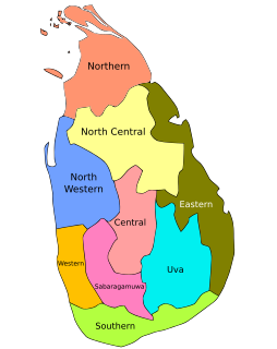
The Western Province is one of the nine provinces of Sri Lanka, the first level administrative division of the country. The provinces have existed since the 19th century but did not have any legal status until 1987 when the 13th Amendment to the Constitution of Sri Lanka established provincial councils. Western Province is the most densely populated province in the country and is home to the legislative capital Sri Jayawardenepura Kotte as well as to Colombo, the nation's administrative and business center.
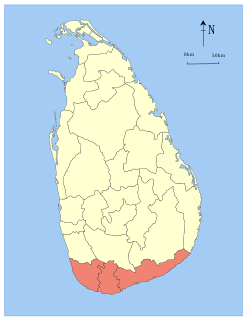
The Southern Province of Sri Lanka is one of the nine provinces of Sri Lanka, the first level administrative division of the country. The provinces have existed since the 19th century but did not have any legal status until 1987 when the 13th Amendment to the Constitution of Sri Lanka established provincial councils. It is the 7th largest province by area and is home to 2.5 million people, the 3rd most populated province. The province is bordered by Sabaragamuwa Province and Uva Province to the North, Eastern Province to the Northeast, Western Province to the Northwest and the Indian Ocean to the South, West and East. The Province's capital is Galle.
In Sri Lanka, provinces are the first level administrative division. They were first established by the British rulers of Ceylon in 1833. Over the next century most of the administrative functions were transferred to the districts, the second level administrative division. By the middle of the 20th century the provinces had become merely ceremonial. This changed in 1987 when, following several decades of increasing demand for a decentralization, the 13th Amendment to the 1978 Constitution of Sri Lanka established provincial councils. Currently there are nine provinces.
The Eastern Province is one of the nine provinces of Sri Lanka, the first level administrative division of the country. The provinces have existed since the 19th century but did not have any legal status until 1987 when the 13th Amendment to the Constitution of Sri Lanka established provincial councils. Between 1988 and 2006 the province was temporarily merged with the Northern Province to form the North Eastern Province. The capital of the province is Trincomalee.

North Western Province is a province of Sri Lanka. The province consists of the districts of Kurunegala and Puttalam. Its capital is Kurunegala, which has a population of 28,571. The province is known mainly for its numerous coconut plantations. Other main towns in this province are Chilaw (24,712) and Puttalam (45,661), which are both small fishing towns. The majority of the population of Wayamba province is of Sinhalese ethnicity. There is also a substantial Sri Lankan Moor minority around Puttalam and Sri Lankan Tamils in Udappu and Munneswaram. Fishing, prawn farming and rubber tree plantations are other prominent industries of the region. The province has an area of 7,888 km2, and a population of 2,370,075.
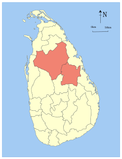
North Central Province is one of the nine provinces of Sri Lanka, the first level administrative division of the country. The provinces have existed since the 19th century but did not have any legal status until 1987 when the 13th Amendment to the Constitution of Sri Lanka established provincial councils. The province is the largest by size, and second least populated in the country. The province consists of the districts of Anuradhapura and Polonnaruwa, both of which were important ancient Sri Lankan kingdoms. The climate is semi-arid, and the forests are dry evergreen forests.

Hikkaduwa is a small town on the south coast of Sri Lanka located in the Southern Province, about 17 km (11 mi) north-west of Galle and 98 km (61 mi) south of Colombo.

Ampara District is one of the 25 districts of Sri Lanka, the second-level administrative divisions of the country. The district is administered by a District Secretariat headed by a District Secretary appointed by the central government of Sri Lanka. The capital of the district is the town of Ampara. The district was carved out of the southern part of Batticaloa District in April 1961.

Matara is a major city in Sri Lanka, on the southern coast of Southern Province. It is the second largest city in Southern Province. It is 160 km (99 mi) from Colombo. It is a major commercial hub, and it is the administrative capital and largest city of Matara District.

The following is a list of schools in Sri Lanka.

Embilipitiya is a town, governed by an urban council, in Ratnapura District, Sabaragamuwa Province, Sri Lanka.

Deshamanya Marhoom Al Haj Mohammed Abdul Bakeer Markar was a Sri Lankan politician and civil servant. He was the Speaker of the Parliament of Sri Lanka and Governor of the Southern Province.
Tangalle is a large town in Hambantota District, Southern Province, Sri Lanka, governed by an Urban Council. It is one of the largest towns in southern province. It is located 195 km (121 mi) south of Colombo and 35 km (22 mi) east of Matara. It has a mild climate, in comparison to the rest of the district, and sandy beaches.

The Central Province is one of the nine provinces of Sri Lanka, the first level administrative division of the country. The Central Province is primarily in the central mountainous terrain of Sri Lanka. It is the 6th largest province by area and is home to 2.5 million people. It is bordered by North Central Province to the north, Uva Province to the east, North Western Province to the west and Sabaragamuwa Province to the south and west. The province's capital is Kandy.
Nagoda is a small town in Sri Lanka. It is located within Southern Province.
Udugama electoral district was an electoral district of Sri Lanka between August 1947 and March 1960. The district was named after the town of Udugama in Galle District, Southern Province. The 1978 Constitution of Sri Lanka introduced the proportional representation electoral system for electing members of Parliament. The existing 160 mainly single-member electoral districts were replaced with 22 multi-member electoral districts. Udugama electoral district was replaced by the Galle multi-member electoral district at the 1989 general elections, the first under the proportional representation system.
Ambalangoda electoral district was an electoral district of Sri Lanka between March 1960 and February 1989. The district was named after the town of Ambalangoda in Galle District, Southern Province. The 1978 Constitution of Sri Lanka introduced the proportional representation electoral system for electing members of Parliament. The existing 160 mainly single-member electoral districts were replaced with 22 multi-member electoral districts. Ambalangoda electoral district was replaced by the Galle multi-member electoral district at the 1989 general elections.
Tangalle electoral district was an electoral district of Sri Lanka between July 1977 and February 1989. The district was named after the town of Tangalle in Hambantota District, Southern Province. The 1978 Constitution of Sri Lanka introduced the proportional representation electoral system for electing members of Parliament. The existing 160 mainly single-member electoral districts were replaced with 22 multi-member electoral districts. Tangalle electoral district was replaced by the Hambantota multi-member electoral district at the 1989 general elections, the first under the proportional representation system.
The following lists events that happened during 1990 in Sri Lanka.
The following lists events that happened during 1997 in Sri Lanka.
