
Odisha, formerly Orissa, is an Indian state located in Eastern India. It is the eighth-largest state by area, and the eleventh-largest by population, with over 41 million inhabitants. The state also has the third-largest population of Scheduled Tribes in India. It neighbours the states of Jharkhand and West Bengal to the north, Chhattisgarh to the west, and Andhra Pradesh and Telangana to the south. Odisha has a coastline of 485 kilometres (301 mi) along the Bay of Bengal in Indian Ocean. The region is also known as Utkaḷa and is mentioned by this name in India's national anthem, Jana Gana Mana. The language of Odisha is Odia, which is one of the Classical Languages of India.

Baripada is a city and a municipality in Mayurbhanj district in the state of Odisha, India. Located along the east bank of the Budhabalanga river, Baripada is the cultural centre of north Odisha. In recent years, it has emerged as an educational hub with the opening of numerous professional colleges.
Balasore, also known as Baleswar, is a city in the state of Odisha, about 215 km (134 mi) from the state capital Bhubaneswar and 300 km (186 mi) from Kolkata, in eastern India. It is the administrative headquarters of Balasore district and the largest city as well as health and educational hub of northern Odisha. It is best known for Chandipur beach. It is also called 'missile city'. The Indian Ballistic Missile Defence Programme's Integrated Test Range is located 18 km south of Balasore.

Cuttack district is one of the 30 districts of Odisha state in India. It is located in the coastal part of the state and its administrative headquarters are located in the city of Cuttack. As of 2011 Census, after Ganjam, it is the second most populous district of Odisha, with a population of 2,624,470. The name is an anglicized form of Kataka or Katak meaning Fort – referring to the Barabati Fort. The district is bisected by the river Mahanadi and its numerous distributaries and occupies a large portion of the river's delta. It is bounded by the Angul, Dhenkanal, Nayagarh and Khurda districts to the west while its southern and eastern boundaries touch Puri, Jagatsinghpur, Kendrapara and Jajpur districts.
Bhadrak is a district of Odisha state in eastern India. Bhadrak city is the headquarters and the largest city of the district.

Gajapati district is a district of Odisha State in India. It was created from Ganjam District on 2 October, 1992. As of 2011 it is the third least populous district of Odisha, after Debagarh and Boudh. The District is a part of the Red Corridor.

Koraput is a town and a Municipality in Koraput district in the Indian state of Odisha. Koraput town is the district headquarter of Koraput district.
Malkangiri, historically known as Malikamardhangiri, is a town and municipality in Malkangiri district in the Indian state of Odisha. It is the headquarter of the Malkangiri district. Malkangiri has been the new home of the East Bengali refugees from erstwhile East Pakistan, who have been rehabilitated since 1965 under the Dandakaranya Project. Some Sri Lankan Tamil refugees were also rehabilitated in the town, following the armed struggle of the Liberation Tigers of Tamil Eelam (LTTE) in the early 1990s, although most of them have now returned to their country. Currently, it is one of the most naxalite-affected areas of the state, and is a part of the Red Corridor.
Sambalpur is the fifth largest city in the Indian State of Odisha. It is located on the banks of river Mahanadi, with a population of 335,761. Prehistoric settlements have been recorded there. It is the home of the Sambalpuri sari.
Nilagiri is a town and a Notified Area Council in Balasore district in the Indian state of Odisha.

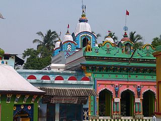
Bhattarika Temple is located on the bank of Mahanadi River, at Sasanga village in the tehsil Baramba,, Cuttack district, Odisha, India. It is dedicated to the Hindu Goddess Maa Bhattarika worshipped as a manifestation of Shakti. As per the Puranic tradition, Parashurama, facing certain defeat at the hands of Saharsrajuna, prayed to Durga who appeared on this spot to impart her divine power to his aid. The festival Pana Sankranti is celebrated here in April, Akshaya Tritiya in May and Dussehra in October.
Bangomunda is a tehsil in the Balangir district of Odisha, India with historical importance. It is located 72 km from the district capital in the city of Balangir. Bangomunda was formerly known as Banganmura which means Brinjal Firm.

Narasinghpur is a town and Notified Area Council in Cuttack district in the Indian state of Odisha.
Padmapur is a village in the Rayagada district of Odisha, India. It is the most populated village and one of the identified tourist centers of the district. A hillock adjoins the village to its northern side. A 7th century inscription found here, in the Nilakantheswar Temple, indicates that the Jagamanda hill, located close by, once housed the monastery of the famous Buddhist logician-philosopher Dharmakirti.
Athagarh is a Vidhan Sabha constituency of Cuttack district, Odisha.
Baramba is a Notified Area Council and Vidhan Sabha constituency of Cuttack district, Odisha.

Baramba State was one of the princely states of India during the period of the British Raj. It had its capital in Baramba town. The last ruler acceded to the Indian Union on 1 January 1948. Baramba state was made part of Cuttack district of Odisha in 1948.
Pramananda Acharya (1893–1971) was an Indian archaeologist known for his notable archaeological research on the history of Odisha. He was honoured by the Government of India in 1964, with the award of Padma Shri, the fourth highest Indian civilian award for his services to the nation.

Tigiria State was one of the princely states of India during the period of the British Raj. It was located in present-day Tigiria block of Cuttack district, Odisha. Although it was the smallest of the states of the Orissa States Agency it was the most densely populated. The last ruler of Tigiria joined the state to the Indian Union in 1948.
Banki or Bānki State was a princely state in Odisha during the British Raj. Its capital was Banki, in the western part of present day Cuttack district.

