Proddatur (1915) is a city in the YSR Kadapa District of Andhra Pradesh, located on the banks of the Penna River. The city is a municipality, and also the mandal headquarters of Proddatur mandal. It is the second-largest town in former Kadapa District. It is the oldest municipality which formed before Independence.
Kandukur or Kandukuru is a town in SPSR Nellore district of the Indian state of Andhra Pradesh. It is a municipality and the headquarters of Kandukur mandal as well as Kandukur revenue division. Kandukur Mandal is located at the south-east side of the Prakasam District having geographical area around 225 km2.There is only 1 city in the Kandukur Mandal, which is Kandukur Municipality having an area of 37.63 km2.

Nagari is a town in Chittoor district of the Indian state of Andhra Pradesh. It is the mandal headquarters of Nagari mandal in Nagari revenue division.
Gudlavalleru is a village and Mandal in Krishna district of the Indian state of Andhra Pradesh. It is located on the Gudivada – Machilipatnam route.

Pathapatnam is a town in Srikakulam district of the Indian state of Andhra Pradesh. It is located in Pathapatnam mandal of Palakonda revenue division. Pathapatnam is located on the border of Srikakulam district of Andhra Pradesh and Gajapati district of Odisha. Parlakhemundi, the headquarters of Gajapati District, can be considered as twin town of Pathapatnam because of its close proximity. It is located around 65 km from srikakulam. It was the old capital of Paralakhemundi Gajapati Maharajah of his erstwhile kingdom.
Polaki is a village in Srikakulam district of Andhra Pradesh in India.
Kondapi is a village in Prakasam district of the Indian state of Andhra Pradesh. It is the mandal headquarters of Kondapi mandal in Kandukur revenue division.
Chintalapudi is a town municipality, constituency and mandal headquarters in Eluru District of the Indian state of Andhra Pradesh. Chintalapudi is one of oldest town in the Andhra Pradesh, but still it is under developed. There is no proper road and transport to the town. People of the town still struggling to reach the nearest cities. There is lot of history around this town, dates back to 600BC to 300BC.The human movement here from 2300 years ago. The village named Jeelakargudem is located 15 km away from here and contains some of the oldest ancient monuments in Buddhism. The carvings on the Sandrock hill are really surprising. According to the ASI and some historians the historical site belongs to Ashoka reign. The historical site is one of the best tourist attraction in the locality, but lack of proper care from government and people the site is ruining. This region is also famous for cultivation of Oil Plam. It's nearly contributes 50% to 60% of total district cultivation of Oil Palm. According to some sources this region contains a vast coal reserves in the country. Your can find more on this in some popular news journals.
Nizampatnam mandal is one of the 25 mandals in Bapatla district of the state of Andhra Pradesh, India. It is under the administration of Repalle Revenue Division and the headquarters are located at Nizampatnam. The mandal is bounded by Repalle, Nagaram, Pittalavanipalem and Karlapalem mandals. The mandals lies on the shore of Bay of Bengal and a portion of the mandal lies on the banks of Krishna River.
Kollipara mandal is one of the 18 mandals in Guntur district of the state of Andhra Pradesh, India. It is under the administration of Tenali revenue division and the headquarters are located at Kollipara. The mandal is situated on the banks of the Krishna River, bordered by Duggirala, Tenali, Vemuru and Kollur mandal.
Narasaraopet mandal is one of the 28 mandals in Guntur district of the India state of Andhra Pradesh. It is under the administration of Narasaraopet revenue division and the headquarters are located at Narasaraopet city. The mandal is bounded by Rompicherla, Nekarikallu, Muppalla, Phirangipuram, Nadendla and Chilakaluripeta. It also borders Prakasam district.

Thullur mandal is one of the 18 mandals in Guntur district of the Indian state of Andhra Pradesh. It is under the administration of Guntur Revenue Division and the headquarters are located at Thullur. The mandal is situated on the banks of Krishna River, bounded by Amaravathi, Tadikonda, Tadepalle and Mangalagiri mandals. The mandal is also a part of the new capital city of Andhra Pradesh to be developed. 18 villages from the mandal fall under the jurisdiction of Andhra Pradesh Capital City.

Narasapuram Mandal is one of the 19 mandals in the West Godavari district of the Indian state of Andhra Pradesh. Its headquarters are in Narasapuram, a town in the mandal. The mandal is bordered by the Godavari River to the north, the Bay of Bengal to the east, the Mogalthur mandal to the south, and the Palacole mandal to the west.
Pinakadimi is a village in Eluru district of the Indian state of Andhra Pradesh. It is located in Pedavegi mandal of Eluru revenue division. It is located at a distance of 7 km from district headquarters Eluru city.

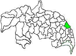
Biccavolu mandal is one of the 19 mandals in East Godavari district of the Indian state of Andhra Pradesh. It is under the administration of Rajahmundry revenue division and the headquarters are located at Biccavolu village. Biccavolu Mandal is bounded by Rayavaram Mandal towards South, Pedapudi Mandal towards East, Anaparthy Mandal towards west, Ramachandrapuram Mandal towards north. It is located ata distance of 41 kilometres from Rajahhmundry.
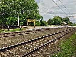
Allipalle is a village in Eluru district of the Indian state of Andhra Pradesh. The nearest railway station is Sitampet(STPT) located at a distance of 47.79 Km.
Chintampalle is a village in West Godavari district of the Indian state of Andhra Pradesh. It is administered under Eluru revenue division.
Palakollu mandal is one of the 46 mandals in the West Godavari district of the Indian state of Andhra Pradesh. The headquarters is located at Palakollu City. The mandal is bordered by Yelamanchili mandal in the north, Narasapuram mandal in the east, Poduru mandal in the south and Veeravasaram mandal in the west.
Challapalli mandal is one of the 25 mandals in the Krishna district of the Indian state of Andhra Pradesh. The headquarters of this mandal are located in Challapalli.
Kandukuru mandal is one of the 38 mandals in Nellore district of the Indian state of Andhra Pradesh. Its headquarters are located at Kandukuru. This mandal is part of Kandukur revenue division.