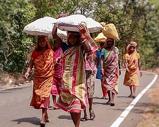
Baripada is a city and a municipality in Mayurbhanj district in the state of Odisha, India. Located along the east bank of the Budhabalanga river, Baripada is the cultural centre of north Odisha. In recent years, it has emerged as an educational hub with the opening of numerous professional colleges.

Mayurbhanj district is one of the 30 districts in Odisha state in eastern India. It is the largest district of Odisha by area. Its headquarters are at Baripada. Other major towns are Rairangpur, Karanjia and Udala. As of 2011, it is the third-most-populous district of Odisha, after Ganjam and Cuttack.

Koraput is a district of India in southern Odisha, with headquarters at Koraput. The district is located in the Eastern Ghats and is known for its hilly terrain, rich and diverse types of mineral deposits and its tribal culture and traditions. The district headquarters of Koraput and its largest city, Jeypore are major centres of trade and commerce for South Odisha and fall on an important road connecting Visakhapatnam to Raipur.
Ho is a Munda language of the Austroasiatic language family spoken primarily in India by about 1.04 million people per the 2001 census. Ho is a tribal language. It is spoken by the Ho, Munda, Kolha and Kol tribal communities of Odisha, Jharkhand, Bihar, Chhattisgarh, West Bengal, Assam and is written with the Warang Citi script. Devanagari, Latin script, Odia script and Telugu script are sometimes used, although native speakers are said to prefer a Ho script. The latter script was invented by Ott Guru Kol Lako Bodra.

West Singhbhum or Pashchimi Singhbhum is one of the 24 districts of Jharkhand state, India. It came into existence on 16 January 1990, when the old Singhbhum district was bifurcated. Chaibasa is the district headquarters.
Bahalda is a small town in the Mayurbhanj district of northern Odisha, India. Bahalda is the second largest town in the Bamanghaty subdivision, and was the capital of Mayurbhanj in the 14th century. Maa Kichakeswari Temple, one of the most famous in northern Odisha, sits in the town.

Maharaja Sriram Chandra Bhanja Deo University, formerly North Orissa University (NOU), is a public university in the regional city of Baripada in the state of Odisha, India.
Lodhi is a Munda language, or dialect cluster, of India. Kharia Thar is only spoken by one quarter of ethnic Lodhi in Orissa. However, while admitting that Lodhi is related to Sora, a Munda language, Ethnologue classifies it as Indic (Bengali–Assamese), and it is considered a variety of Hindi in the Indian census. It may be that there are both Munda and Indic varieties subsumed under the name Lodhi.
Thakurmunda is a block headquarter and a small market area in Mayurbhanj district in the state of Odisha, India. Thakurmunda is referred as the largest block of mayurbhanj district having a radius of 40kms. The nearest city is Karanjia. Thakurmunda is a place to stay and tour the Mayurbhanj region. This region is home to Similipal, one of the most important wildlife parks of India. The national park comprises lush valleys, forest lands and scores of ancient temples.
Badasahi is a Vidhan Sabha constituency of Mayurbhanj district, Odisha.
Morada is a Vidhan Sabha constituency of Mayurbhanj district, Odisha.
Rairangpur is a constituency of the Odisha Legislative Assembly, in Mayurbhanj district, Odisha.
Saraskana is a Vidhan Sabha constituency of Mayurbhanj district, Odisha.
Udala is a Vidhan Sabha constituency of Mayurbhanj district, Odisha.

Bagal is a cattle herding caste of East India. Bagal people are living in the state of West Bengal, Jharkhand and Odisha. They use Kudmali / Bengali Manbhumi dialect as mother tongue and use Bengali, Hindi and Odia language to communicate with the society.
Sunei Dam is a dam located in Odisha, India.Sunei Dam is located at latitude 21° 28‘ N, longitude 87° 28’ E, at Salchua Village, about 21 km south of Udala town. The drainage area of Sunei up to the confluence with the Burhabalanga river is nearly 1200 km2, while the catchment area of the dam site is 227 km sq.
Kala Dam is the dam in the Mayurbhanj district in the state of Odisha, India. It is located 8 km from Kaptipada, Mayurbhanj. The Dam is near about 2 km in length and 3.5 km in breadth. It covers a wide area with plenty of water. The Dam provides water throughout the year to the villagers for cultivation and other things.
Kaptipada is a community development block that forms an administrative division in Kaptipada subdivision of Mayurbhanj district in the Indian state of Odisha. Kaptipada was a Kaptipada estate, which was merged with Mayurbhanj State in 1890.

Haripur gada is the capital of the erstwhile Mayurbhanj State in India. It is located in Badsahi Block of the Mayurbhanj district, on the bank of the Budhabalanga river.


