
Rajasthan is a state in northern India. It covers 342,239 square kilometres (132,139 sq mi) or 10.4 per cent of India's total geographical area. It is the largest Indian state by area and the seventh largest by population. It is on India's northwestern side, where it comprises most of the wide and inhospitable Thar Desert and shares a border with the Pakistani provinces of Punjab to the northwest and Sindh to the west, along the Sutlej-Indus River valley. It is bordered by five other Indian states: Punjab to the north; Haryana and Uttar Pradesh to the northeast; Madhya Pradesh to the southeast; and Gujarat to the southwest. Its geographical location is 23°.3' to 30°.12' North latitude and 69°.30' to 78°.17' East longitude, with the Tropic of Cancer passing through its southernmost tip.
Bikaner is a city in the northwest of the state of Rajasthan, India. It is located 330 kilometres (205 mi) northwest of the state capital, Jaipur. Bikaner city is the administrative headquarters of Bikaner District and Bikaner division.

Jodhpur is the second-largest city in the Indian state of Rajasthan and officially the second metropolitan city of the state. It was formerly the seat of the princely state of Jodhpur State. Jodhpur was historically the capital of the Kingdom of Marwar, which is now part of Rajasthan. Jodhpur is a popular tourist destination, featuring many palaces, forts, and temples, set in the stark landscape of the Thar Desert. It is popularly known as the "Blue City" among people of Rajasthan and all over India. It serves as the administrative headquarters of the Jodhpur district and Jodhpur division.
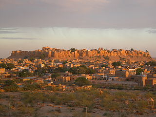
Jaisalmer(pronunciation), nicknamed "The Golden city", is a city in the Indian state of Rajasthan, located 575 kilometres (357 mi) west of the state capital Jaipur. It is the administrative headquarters of Jaisalmer District. Before Indian independence, the town served as the capital of the Jaisalmer State, ruled by the Bhati Rajputs. Jaisalmer stands on a ridge of yellowish sandstone and is crowned by the ancient Jaisalmer Fort. This fort contains a royal palace and several ornate Jain temples. Many of the houses and temples of both the fort and of the town below are built of finely sculptured sandstone. The town lies in the heart of the Thar Desert and has a population, including the residents of the fort, of about 78,000.
Churu is a city in the desert region of Rajasthan state of India. It is known as the gateway to the Thar Desert of Rajasthan. It is the administrative headquarter of Churu District. It lies in the Thar Desert on the National Highway 52 connecting Sangrur to Ankola and is a junction station on the railway line to Bikaner. It is near the shifting sand dunes of the Thar Desert and has grand havelis with marvelous fresco paintings, namely Kanhaiya Lal Bagla Ki Haweli and Surana Haweli, with hundreds of small windows. It also has some fine Chhatris. Near the town is a religious seat of the Nath sect of Sadhus where there are life-size marble statues of their deities and a place for prayers. At the center of the town is a fort built about 500 years ago.

Mehrangarh Fort covers an area of 1,200 acres in Jodhpur, Rajasthan, India. The complex is located on a hilltop around 122 metres above the surrounding plain, and was constructed c. 1459 by Rajput ruler Rao Jodha, though most of the existing structure is from the 17th century. Inside its boundaries there are several palaces known for their intricate carvings and expansive courtyards, as well as a museum housing various relics. A winding road leads to and from the city below. The imprints of the impact of cannonballs fired by attacking armies of Jaipur can still be seen on the second gate. At the north-east of the fort is the chhatri of Kirat Singh Soda, a soldier who fell on the spot defending Mehrangarh.

Nagaur is a city and municipal council in Nagaur district of the state of Rajasthan in India. It is the administrative headquarters of Nagaur District. The Nagaur city lies about midway between Jodhpur and Bikaner.

Chittorgarhpronunciation (help·info) is a major city in Rajasthan state of western India. It lies on the Berach River, a tributary of the Banas, and is the administrative headquarters of Chittorgarh District. It was a major stronghold of the Rajput State of Medapata. The city of Chittorgarh is located on the banks of river Gambhiri and Berach.

Mandore is a suburb Historical town located 9 km north of Jodhpur city, in the Indian state of Rajasthan.
The Chittorgarh, also known as Chittod Fort, is one of the largest forts in India. It is a UNESCO World Heritage Site. The fort was the capital of Mewar and is located in the present-day city of Chittorgarh. It sprawls over a hill 180 m (590.6 ft) in height spread over an area of 280 ha above the plains of the valley drained by the Berach River. The fort covers 65 historic structures, which include four palaces, 19 large temples, 20 large water bodies, 4 memorials and a few victory towers.
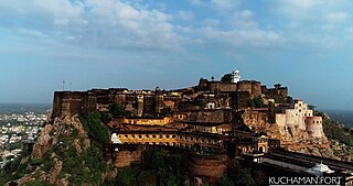
Kuchaman is a city located in Urban Area of central-west Rajasthan, India. It is a part of Didwana Kuchaman District in the Indian state of Rajasthan. The city includes a lots of Havelis in the Shekhawati and Marwari style and a fort overlooking the city. Fresco paintings of this city depict flowers, motifs, and Hindu mythology.The Kuchaman city lies about midway between Jodhpur, Jaipur, Ajmer and Sikar.

Merta City is a city and a municipality located, near Nagaur City in Nagaur district in the Indian state of Rajasthan. Merta is also known for its link with Mira Bai, the devotee of Lord Krishna. Mira Mahal Museum houses memories related to Mira Bai's lifetime

Vijayender Pal Singh Badnore is an Indian politician who was the 28th Governor of Punjab. He was a member of Rajya Sabha, elected on 17 June 2010. He was earlier a member of the 14th Lok Sabha and 13th Lok Sabha of the Indian Parliament. He represented the Bhilwara constituency of Rajasthan and is a member of the Bharatiya Janata Party (BJP) political party from 1999 to 2009 and also 4 time Member of Rajasthan Legislative Assembly.
Ghanerao is a village in Desuri tehsil of Pali district of Rajasthan.
Muhnot Nainsi (1610–1670) is known for his studies of the region now encompassed by the state of Rajasthan in India.
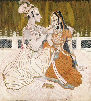
Apart from the architecture of Rajasthan, the most notable forms of the visual art of Rajasthan are architectural sculpture on Hindu and Jain temples in the medieval era, in painting illustrations to religious texts, beginning in the late medieval period, and post-Mughal miniature painting in the Early Modern period, where various different court schools developed, together known as Rajput painting. In both cases, Rajasthani art had many similarities to that of the neighbouring region of Gujarat, the two forming most of the region of "Western India", where artistic styles often developed together.
The siege of Chittorgarh was military expedition of the Mughal Empire under Akbar against the Mewar kingdom that commenced in 1567 during which the Mughals successfully captured the fort of Chittorgarh after a hard-pressed siege which lasted for several months.
Maroth is a village located in Nawa, Nagaur district, in the state of Rajasthan, India. The area surrounding the village is named Gaurati, which means "The Land of Gaurs". This area was a principality granted by Maharaja Vigharaj Chauhan to Maharaja Bawan Gaur in 1260 AD. In 1659 AD, it was granted by Aurangzeb to Maharaja Raghunath Singh for his service in battle. During this time period the Gaur Rajputs of this area paid more than 6.65% of the Jama (tax) of the principality according to Ain-A-Akbari.

Jaimal Rathore (1507–1568) was the Rathore ruler of Merta. He was cousin of the Hindu saint Mirabai and became the ruler of Merta after the death of his father, Rao Veeram Dev. His father was perceived as the strongest king of the east in his time. The Amar Kavya records that Udai Singh II granted Badnor along with 210 villages to Rao Jaimal. In 1553, Jaimal resisted falling under the chakri of Maldeo of Marwar.
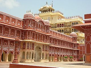
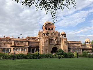
Rajput architecture is an architectural style notable for the forts and palaces of the many Rajput rulers, which are popular tourist attractions, many of the Rajput forts are UNESCO World Heritage Site.
