
The Kerguelen Islands, also known as the Desolation Islands, are a group of islands in the Antarctic constituting one of the two exposed parts of the Kerguelen Plateau, a large igneous province mostly submerged by the southern Indian Ocean. They are among the most isolated places on Earth, located more than 3,300 km (2,100 mi) from Madagascar, the nearest permanently populated location; Heard Island is 450 km (280 mi) to the south-east. The islands, along with Adélie Land, the Crozet Islands, Amsterdam and Saint Paul Islands, and France's Scattered Islands in the Indian Ocean, are part of the French Southern and Antarctic Lands and are administered as a separate district.

The Gaspésie, or Gaspé Peninsula, the Gaspé or Gaspesia, is a peninsula along the south shore of the Saint Lawrence River to the east of the Matapedia Valley in Quebec, Canada, that extends into the Gulf of Saint Lawrence. It is separated from New Brunswick on its southern side by the Baie des Chaleurs and the Restigouche River. The name Gaspé comes from the Mi'kmaq word gespe'g, meaning "end", referring to the end of the land.
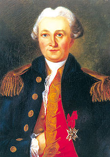
Yves-Joseph de Kerguelen-Trémarec was a French Navy officer. He is notable for discovering the Kerguelen Islands, and for authoring books about expeditions and about French naval operations during the American War of Independence. Welcomed as a hero after his First voyage of exploration, Kerguelen fell out of favour after his Second voyage and was cashiered for violating Navy regulations. He was rehabilitated during the French Revolution.

The Kerguelen Plateau, also known as the Kerguelen–Heard Plateau, is an oceanic plateau and a large igneous province (LIP) located on the Antarctic Plate, in the southern Indian Ocean. It is about 3,000 km (1,900 mi) to the southwest of Australia and is nearly three times the size of Japan. The plateau extends for more than 2,200 km (1,400 mi) in a northwest–southeast direction and lies in deep water.

The Municipality of Gros-Mécatina is on the Lower North Shore of the Gulf of Saint Lawrence, near the border with Labrador in Quebec, Canada. Located near crab, lobster, and scallop fishing grounds, it is dependent on the fishing business, including a fish processing factory that contributes to regional economic activity.

Blanc-Sablon is the easternmost community in Le Golfe-du-Saint-Laurent Regional County Municipality, in the administrative région of Côte-Nord, in the province of Quebec, Canada. With a population of 1,118 inhabitants, it is the most populous community in the county municipality.

Île Saint-Lanne Gramont is an uninhabited island, the fourth largest island in the Kerguelen Islands, situated to the north of presqu'île de la Société de géographie, with an area of 45.8 km². It reaches 480 m at its highest point and is located at 48°55′25″S69°10′54″E. The island is elongated along a north–south axis, reaching a maximum length of 13 km and a maximum width of 3 km. It is free of introduced animals.

Île Foch is one of the Kerguelen Islands situated near to the north coast of Grande Terre, the principal island.

Île Howe is one of the islands of the Kerguelen archipelago, situated to the north of Île Foch, just after Île MacMurdo. It is about 8 km in length. Apart from rabbits, it is free of introduced animals.
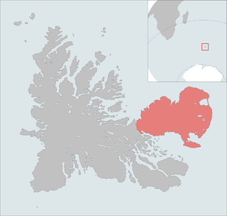
The Courbet Peninsula is a peninsula in northeastern Grande Terre Island, the main island of the subantarctic Kerguelen Archipelago, Southern Indian Ocean. In the south of the peninsula is Port-aux-Français, the principal station of the archipelago.
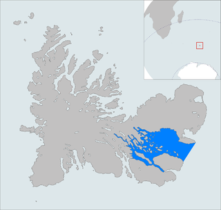
The Golfe du Morbihan is a bay on the eastern coast of Grande Terre, the largest of the Kerguelen islands. It forms a deep and broad notch in the central section of the island.

Baie de l'Isle-Verte is a 22.2 square kilometres (8.6 sq mi) coastal wetland along the southern shore of the Saint Lawrence River in Quebec, Canada. It was designated a Ramsar wetland of international importance on May 27, 1987, is classified as a globally significant Important Bird Area, and contains a National Wildlife Area and Migratory Bird Sanctuary. It is located in the Rivière-du-Loup Regional County Municipality, in the municipality of L'Isle-Verte.

The Péninsule Loranchet, also known as Presqu'île Loranchet, is a peninsula of Grande Terre, the main island of the subantarctic Kerguelen archipelago in the southern Indian Ocean.

Baie Larose, or Larose Bay in English, is a bay of Grande Terre, the main island of the subantarctic Kerguelen archipelago, a French territory in the southern Indian Ocean. It is important as a breeding site for seabirds, especially penguins.

The Kikendatch Bay is a freshwater body that leads to the Gouin Reservoir, in the territory of La Tuque, in Haute-Mauricie, in the administrative region of Mauricie, in the province of Quebec, in Canada.
Dauphine was a small 4-gun corvette of the French Navy. She is notable for the rescue operation to Tromelin Island that gave it its present name, and for taking part in the Second voyage of Kerguelen. The Baie de la Dauphine, in the Kerguelen Archipelago, is named in her honour.
Oiseau was a 32-gun frigate of the French Navy.
Baie de l'Oiseau is a natural harbour in the Loranchet Peninsula, in the North-Western part of the island Grande Terre, part of the Kerguelen Islands. It was the landing site of the expedition under Yves de Kerguelen in 1772, and later of the expedition under James Cook in 1776. The site of Port-Christmas is part of the bay.

The Kerguelen Arch is a former natural arch of the French Southern and Antarctic Lands. The arch collapsed between 1908 and 1913. It is located on the littoral zone on the cape between Baie de l'Oiseau and Baie de la Dauphine, North of the Loranchet Peninsula on the island of Grande Terre, main island of the Kerguelen archipelago. It is one of the best-known structures of the era, and its twin pillars are depicted of numerous postage stamps of the TAAF.
The Second voyage of Kerguelen was an expedition of the French Navy to the southern Indian Ocean conducted by the 64-gun ship of the line Roland, the 32-gun frigate Oiseau, and the corvette Dauphine, under Captain Kerguelen. The aims of the expedition were to confirm the findings of the First voyage of Kerguelen, returning the Kerguelen Islands and exploring what was thought to be a peninsula of a southern continent.