The Bajuni Islands (Somali: Jasiiradaha Jubbada Hoose; Italian: Isole Giuba, also known as the Bajun Islands[1] or Baajun Islands) are an archipelago in southern Somalia.[2] They are situated in the Somali sea off the southern coast of Jubaland, from Kismayo to Ras Kamboni.
Chula, where the village of Ndowa is situated, is the only island with a significant population
In addition, there are several smaller islands, including Kandha Iwu, Fuma, and Ilisi. The island of Kismayo was attached to the coast in 1961 during the construction of Kismayo Port.
History
The islands were part of the ancient Somali empires [dubious–discuss], merchants, and fishermen who used it as an offshoot to trade with other civilizations in the spice world.[citation needed] The Somali Ajuran Dynasty utilized it for centuries as part of their kingdom. After the decline of several Somali empires later, the islands became less inhabited until the colonial invasion by the British East Africa prior to World War I.[1] The Bajuni Islands formed a constituent part of British Jubaland. In 1924, mainland Jubaland was ceded to Italy, while the Bajuni Islands were transferred two years later.[1][3]
According to C. Wightwick Haywood, a British official in Kismayo who visited the islands in 1913, the only inhabited islands in the chain were Chovaye and Chula. Maize, millet, sweet potatoes and coconuts were grown on the islands, and dhows were used for transportation. While there, Haywood saw ruins of what he described as a "fair-sized town" on Chovaye. He mentioned that similar stone scrollwork could also be seen on houses in the Lamu Islands. Haywood thought some of the residents to be of Arab or Persian descent.[1]
Demographics
The islands are today mainly inhabited by the eponymous Bajuni people.[4]
↑ Mwangi, Oscar Gakuo. "Jubbaland: Somalia’s new security dilemma and state-building efforts." Africa Review 8.2 (2016): 120-132.
↑ Cassanelli, Lee. "The Opportunistic Economics of the Kenya-Somali Borderland in Historical Perspective." Borders and Borderlands as Resources in the Horn of Africa (2010): 133-150.
↑ Land, Property, and Housing in Somalia - Page 52, Gregory Norton - 2008
Lower Juba is an administrative region (gobol) in southern Somalia. With its capital at Kismayo, it lies in the autonomous Jubaland region. It has green forests and wildlife including lions, giraffes, hippos, crocodiles, and hyenas.
The Jubba River or Juba River is a river in southern Somalia which flows through the region of Jubaland. It begins at the border with Ethiopia, where the Dawa and Ganale Dorya rivers meet, and flows directly south to the Somali Sea, where it empties at the Goobweyn juncture. The Jubba basin covers an area of 749,000 km2 (289,000 sq mi). The Somali regional state of Jubaland, formerly called Trans-Juba, is named after the river.
Greater Somalia sometimes also called Greater Somaliland is the geographic location comprising the regions in the Horn of Africa in which ethnic Somalis live and have historically inhabited.
Kismayo is a port city in the southern Lower Juba province of Somalia. It is the commercial capital of the autonomous Jubaland region.
Afmadow is a city in southern Somalia, located in the middle of the Juba region and bordered by Kenya, Badhadhe, Kismayo, Jamame, Jilib, Hagar, Bardhere and Elwaq in Somalia, it's 401 km southwest of the capital Mogadishu. It is home to a wide variety of wild animals, including the Big Five game animals. The vegetation in Afmadow consists of rich grassland, bounded by semi-desert. It is located northwest of Kismayo. The distance between Afmadow and Kismayo is 110 kilometers or 68 miles.
Bardere also known as Bardera, is a city in Jubaland State of Somalia. It is the second most populous city in Jubaland with Kismayo being the largest and most densely populated city in the region. Bardere sits on the Jubba River around 250 km west of the city of Baidoa and is in a highland area with fertile soil.
The Marehan is a Somali clan, which is part of one of the largest Somali clan families, the Darod.
Garissa is the capital of Garissa County, Kenya. It is situated in the former North Eastern Province.
The endoglossic language of Somalia has always been Somali, although throughout Somalia's history various exoglossic languages have also been used at a national level.
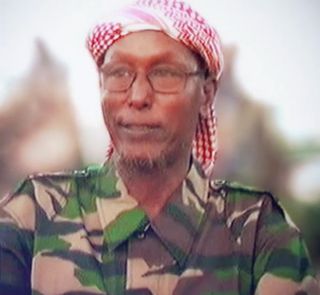
Sheikh Hassan Abdullah Hersi al-Turki was a Somali Islamist who was a senior leader within al-Itihaad al-Islamiya (AIAI) and the Islamic Courts Union (ICU).
The Bajuni people are a Bantu ethnic group who live primarily in the city of Mombasa in Kenya. Many relocated from southern Somalia to Kenya due to war with the Oromo clan Orma, who drove them out from their ancestral territory.
Oltre Giuba or Trans-Juba was an Italian colony in the territory of Jubaland in present-day southern Somalia. It lasted from 1924 until 1926, when it was absorbed into Italian Somaliland. Transjuba is the former name of Jubaland, a federal member state of Somalia.
Koyama is an island in southern Somalia, in the region of Jubaland.
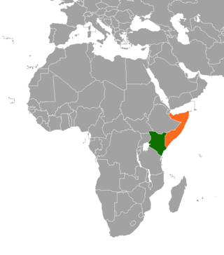
Kenya–Somalia relations are bilateral relations between Kenya and Somalia. Both countries are members of the African Union and Non-Aligned Movement.
Jubaland, or the Juba Valley, is a Federal Member State in southern Somalia. Jubba River, stretching from Dolow to the Indian Ocean, while its western side flanks the North Eastern Province in Kenya, which was carved out of Jubaland during the colonial period.
The Port of Kismayo, also known as the Kismayo Port, is the official seaport of Kismayo, situated in southern Somalia. It is classified as a major class port. It has a harbour as well as a pier which juts into the Somali Sea.
Burgabo is a port town in Lower Jubba province in southern Somalia near the border with Kenya. Other names and variants of the town include Berikau, Bircao, Birikao, Birikau, Las Bur Gabo, Bur Gao, Bur Gavo, Hohenzollernhafen, Port Dunford, Port Durnford and Wubushi.
Chula is an island that is a part of the Bajuni Islands archipelago in southern Somalia in the Somali Sea. It is the most populated of the six islands.
Chovaye is an island that is a part of the Bajuni Islands archipelago in southern Somalia. in the Somali Sea. It does not have a permanent population, but rather only migratory fishermen. It is also called Tovai.
Jubaland has had a wide array of flags in its modern history, ranging from that during its British East Africa Province of Jubaland era, during the transitionary Trans-Juba period of Jubaland, as well as the current Jubaland's federal state flag.
This page is based on this Wikipedia article Text is available under the CC BY-SA 4.0 license; additional terms may apply. Images, videos and audio are available under their respective licenses.