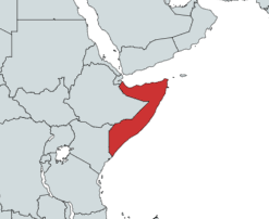
Somalia is a country located in the Horn of Africa which officially consists of the intra-46th meridian east territory, the seven federal member states, namely Galmudug, Hirshabelle, Jubaland, South West, Puntland, and the municipality of Benadir. It is bordered by Ethiopia to the west, the Gulf of Aden to the north, the Somali Sea and Guardafui Channel to the east, and Kenya to the southwest. With a land area of 637,657 square kilometers, Somalia's terrain consists mainly of plateaus, plains and highlands. Its coastline is more than 3,333 kilometers in length, the longest of mainland Africa. It has been described as being roughly shaped "like a tilted number seven".

Lower Juba is an administrative region (gobol) in southern Somalia. With its capital at Kismayo, it lies in the autonomous Jubaland region. It has green forests and wildlife including lions, giraffes, hippos, crocodiles, and hyenas.

Somalia is a federal republic consisting of federal states, Puntland, Jubaland, Galmudug, Khaatumo, South West, and Hirshaabelle and one interim administration. Somalia is further subdivided into 18 administrative regions, which are in turn subdivided into districts. One region, Banaadir, is not part of any state.
Kismayo is a port city in the southern Lower Juba province of Somalia. It is the commercial capital of the autonomous Jubaland region.
The Bajuni Islands are an archipelago in southern Somalia. They are situated in the Somali sea off the southern coast of Jubaland, from Kismayo to Ras Kiyamboni.
The Dhulbahante is a Somali clan family, part of the Harti clan which itself belongs to the largest Somali clan-family — the Darod. They are the traditional inhabitants of the physiographic Nugaal in its topographic sense, and its pre-independence administrative sense, which included Doollo. The clan's progenitor is buried at Badweyn.
The Darod is a Somali clan. The forefather of this clan is Sheikh Abdirahman bin Isma'il al-Jabarti, more commonly known as Darod. The clan primarily settles the apex of the Horn of Africa and its peripheries, the Somali hinterlands adjacent to Oromia (Ogaden), and both sides of the Kenya–Somalia border. The Darod clan is the largest Somali clan family in the Horn of Africa.

Lamu County is a county in Kenya located along the North Coast of the country and is one of the six Coastal Counties in Kenya. Its capital is the town of Lamu. It borders Tana River County to the southwest, Garissa County to the north, Somalia to the northeast, and the Indian Ocean to the South.

Mombasa County is one of the 47 counties of Kenya. Its capital is Mombasa. In terms of economy it is second after Nairobi. Initially it was one of the former districts of Kenya but in 2013 it was reconstituted as a county, on the same boundaries. It is the smallest county in Kenya, covering an area of 229.7 km2 excluding 65 km2 of water mass. The county is situated in the south eastern part of the former Coast Province. It borders Kilifi County to the north, Kwale County to the south west and the Indian Ocean to the east. Administratively, the county is divided into seven divisions, eighteen locations and thirty sub-locations.
The Marehan is a Somali clan, which is part of one of the largest Somali clan families, the Darod.

Demographic features of Somalia's inhabitants include ethnicity, language, population density, education level, health, economic status, religious affiliations and other aspects of the population. Somalia is believed to be one of the most homogeneous countries in Africa.

The endoglossic language of Somalia has always been Somali, although throughout Somalia's history various exoglossic languages have also been used at a national level.
The Harti, (Somali: Harti, Arabic: هرتي, lit. 'strong man'), are a Somali clan that trace their lineage back to SalehAbdi (Harti). They are a sub-clan of the larger Darod clan. Notable sub-clans within Harti include the Majeerteen, Dhulbahante, and the Warsengeli. They predominantly reside in the apex of the Horn of Africa and its surrounding regions. Furthermore, in the southern territories, the clan's settlements span both sides of the Kenya-Somalia border.

Garissa County is an administrative county in Kenya. It is located in Eastern Kenya bordering Somalia to the East, Wajir County and Isiolo County to the North, Tana River County to the West and Lamu County to the South. Its capital and largest urban area is Garissa.

The Bajuni people are a Bantu ethnic group who live primarily in the Bajuni Islands of Somalia and coastal areas between the port city of Kismayo and the city of Mombasa in Kenya. Many relocated from Somalia to Kenya due to war with the Orma, who drove them out from their ancestral territory.

Oltre Giuba or Trans-Juba was an Italian colony in the territory of Jubaland in present-day southern Somalia. It lasted from 1924 until 1926, when it was absorbed into Italian Somaliland. Transjuba is the former name of Jubaland, a federal member state of Somalia.

Jubaland, the Juba Valley, is a Federal Member State in southern Somalia. Jubba River, stretching from Dolow to the Indian Ocean, while its western side flanks the North Eastern Province in Kenya, which was carved out of Jubaland during the colonial period.
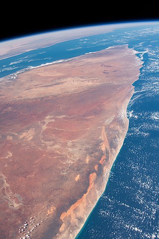
Somalia's coastline consists of the Gulf of Aden to the north, the Guardafui Channel to the northeast and the Indian Ocean to the east. The total length of the coastline is approximately 3333 km, giving the country the longest coastline on mainland Africa. The country has second-longest coastline in all of Africa, behind the island nation of Madagascar.
Chovaye is an island that is a part of the Bajuni Islands archipelago in southern Somalia. in the Somali Sea. It does not have a permanent population, but rather only migratory fishermen. It is also called Tovai.

The Baho Nugaaleed the leader baho nugaaleed Khair Abdi [Qayaad], is a division of Somali clan that is part of the Dhulbahante clan-family. The primary homeland of these clans include the regions of Sool and Sanaag And Dmco Doollo DDS in SSC KHAATUMO, the Lower Juba region in Somalia and the Dollo Zone in Ethiopia. The Bah Nugaaleed are composed of three major sub-groups Qayaad Majors in accordance with their locality in the SSCD regions. These groups are Khair Abdi [Qayaad] the Hayaag Yaxye ugaasyo the Reer Aymeed and Reer Nugaaleed _Reer hawud [KhAIR ABDI]Qayaad).
