Related Research Articles

Lincoln County is a county located in the U.S. state of Mississippi. As of the 2020 census, the population was 34,907. Its county seat is Brookhaven. The county was created by the legislature on April 7, 1870, during the Reconstruction Era. It was formed from portions of Lawrence, Pike, Franklin, Copiah, and Amite counties. It was named for Abraham Lincoln, the 16th President of the United States. Lincoln County comprises the Brookhaven, MS Micropolitan Statistical Area, which is included in the Jackson–Vicksburg–Brookhaven Combined Statistical Area. The county is southwest of the state capital of Jackson.

Washington Parish is a parish located in the interior southeast corner of the U.S. state of Louisiana, one of the Florida Parishes. As of the 2020 census, the population was 45,463. Its parish seat is Franklinton. Its largest city is Bogalusa. The parish was founded in 1819.

Bogue Chitto is a census-designated place (CDP) situated in Kemper and Neshoba counties, Mississippi. The population was 864 at the 2020 census. It is part of the Mississippi Band of Choctaw Indians Reservation and the population is 93% Choctaw.

The Pearl River is a river in the U.S. states of Mississippi and Louisiana. It forms in Neshoba County, Mississippi from the confluence of Nanih Waiya and Tallahaga creeks, and has a meander length of 444 miles (715 km). The lower part of the river forms part of the boundary between Mississippi and Louisiana.
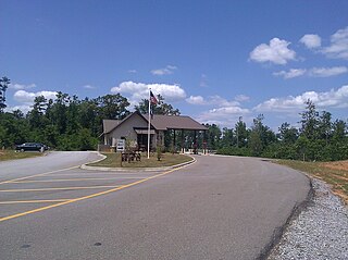
Bogue Chitto State Park is a Louisiana state park located off Louisiana State Highway 25 south of Franklinton, in Washington Parish. The name Bogue Chitto is from the Choctaw language, bok chito, meaning big creek. Bogue Chitto is a relatively recent addition to the Louisiana State Park system. It opened to the public on August 28, 2010, after a delay of approximately three months.
Bogue Chitto is an unincorporated community in Dallas County, Alabama. It was named for the nearby creek of the same name, which in the Choctaw language means "big stream."
Belle Helene is an unincorporated community in Ascension Parish, Louisiana, United States.
Grant Creek is a stream in Beltrami County, Minnesota, in the United States.
Riley Creek is a 22.2-mile (35.7 km) long stream in the U.S. state of Ohio. It is a tributary of the Blanchard River.
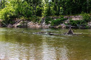
The Bogue Chitto River is a stream in the U.S. states of Louisiana and Mississippi. It is a tributary of the Pearl River.
Brushy Fork is a stream in Miller County in the U.S. state of Missouri. It is a tributary of Tavern Creek.
Belfast is an unincorporated community in Newton County, in the U.S. state of Missouri. The community lies above the south bank of Lost Creek and is approximately four miles west of Neosho. The St. Louis–San Francisco Railway passes the community along Lost Creek valley.
East Deep Creek is a stream tributary to Deep Creek in Tooele County, Utah.
Fifteenmile Creek is a tributary stream of East Deep Creek, in Juab County, Utah and Tooele County, Utah.
Besa Chitto Creek is a stream in the U.S. state of Mississippi. It is a tributary to the Yockanookany River with a name derived from the Choctaw language meaning "blackberry big creek".

Chickasawhay Creek is a stream in the U.S. state of Mississippi. It is a tributary to Okatibbee Creek.

Hobolochitto Creek is a stream in the U.S. state of Mississippi.
Topisaw Creek is a stream in the U.S. state of Mississippi. It is a tributary to Bogue Chitto.
References
- ↑ U.S. Geological Survey Geographic Names Information System: Bala Chitto Creek
- ↑ Baca, Keith A. (2007). Native American Place Names in Mississippi. University Press of Mississippi. p. 7. ISBN 978-1-60473-483-6.
30°59′54″N90°27′16″W / 30.99833°N 90.45444°W