Related Research Articles
Kamala Nehru Park is part of the Hanging Gardens complex in Mumbai, Maharashtra, India covering an area of approximate 16,000 sq.mt.. Located at the top of Mumbai's Malabar Hill, it is developed and maintained by the Hydraulic Engineer's Department of Municipal Corporation of Greater Mumbai. One of Mumbai's premier gardens it is popular with young children and tourists. The garden has views of the Marine drive below - also known as Queen's necklace.

Jhanjharpur is a town and a sub-division in the Madhubani district of the state of Bihar, India. Jhanjharpur is well connected to the other cities of India with railways.
Kamala refers to:

Madhubani (DELHI PUBLIC SCHOOL BASUARA) is a City Municipal Corporation and headquarter of Madhubani district. Madhubani is situated in the Indian state of Bihar. It comes under Darbhanga Division. It is situated at 26 km northeast of Darbhanga City. The Madhuban Raj in Madhubani was created as a consequence. The word "Madhuban" means "forest of honey", from which Madhubani is derived, but sometimes it is also known as "madhu"+"vaani" meaning "sweet" "voice/language".

Kamala Nehru was an Indian independence activist and the wife of Jawaharlal Nehru, the first prime minister of India. Their daughter Indira Gandhi was the first female prime minister of India.

Kamala Das , popularly known by her one-time pen name Madhavikutty, was an Indian poet in English as well as an author in Malayalam from Kerala, India. Her popularity in Kerala is based chiefly on her short stories and autobiography, while her oeuvre in English, written under the name Kamala Das, is noted for the poems and explicit autobiography. She was also a widely read columnist and wrote on diverse topics including women's issues, child care, politics, etc. Her liberal treatment of female sexuality, marked her as an iconoclast in popular culture of her generation. On 31 May 2009, aged 75, she died at Jehangir Hospital in Pune.

Janakpurdham or Janakpur is a sub-metropolitan city in Dhanusha district, Madhesh Province, Nepal. The city is a hub for religious and cultural tourism. A headquarter of Dhanusha district, Janakpur is also the capital for Madhesh Province.

Mahendra Highway, also called East-West Highway, runs across the Terai geographical region of Nepal, from Mechinagar in the east to Bhim Datta in the west, cutting across the entire width of the country. It is the longest highway in Nepal and was constructed by cooperation of various countries. The highway is named after King Mahendra Shah.
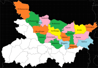
Bihar is located in the eastern region of India, between latitudes 24°20'10"N and 27°31'15"N and longitudes 83°19'50"E and 88°17'40"E. It is an entirely land–locked state, in a subtropical region of the temperate zone. Bihar lies between the humid West Bengal in the east and the sub humid Uttar Pradesh in the west, which provides it with a transitional position in respect of climate, economy and culture. It is bounded by Nepal in the north and by Jharkhand in the south. Bihar plain is divided into two unequal halves by the river Ganges which flows through the middle from west to east. Bihar's land has average elevation above sea level of 173 feet.
Bihar is India's most flood-prone state, with 76% of the population of North Bihar living under the recurring threat of devastating flooding. Bihar makes up 16.5% of India's flood-affected area and contains 22.1% of India's flood-affected population. About 73.06% of Bihar's geographical area, 68,800 square kilometres (26,600 sq mi) out of 94,160 square kilometres (36,360 sq mi), is affected. Each year, floods kill many and damage livestock and other assets worth millions. In total, floods have claimed 9,500 lives since the government started publishing figures in 1979. North Bihar districts are vulnerable to at least five major flood-causing rivers during monsoon – the Mahananda, Koshi, Bagmati, Burhi Gandak, and Gandak rivers – which originate in Nepal. Some South Bihar districts have also become vulnerable to floods, from the Son, Punpun, and Phalgu rivers. The 2013 flood affected over 5.9 million people in 3,768 villages in 20 districts in the state. The 2017 flood affected 19 districts in North Bihar, killing 514 people and affecting over 17 million.
Kamla may refer to:
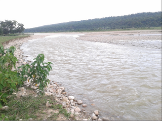
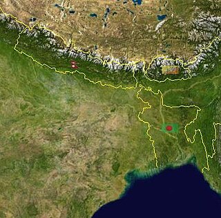
The Kamala River originates in Nepal and flows through the Indian state of Bihar.
Ramaul is a village in Siraha Municipality in Siraha District in the Madhesh Province of south-eastern Nepal. It is surrounded by Makhanaha from the east side, Basbitta from the north-west side, Manpur from the south-west side, Madar from the south-north side and Kamala River from the west side. At the time of the 1991 Nepal census it had a population of 5000 people living in 400 individual households. Before it was under the Village development committee, of Siraha Nepal in 1991 Nepal census. Now it lies under the Siraha Municipality-3,4, and 5. It is divided into five areas (Tolas): Purab Tola, Uttar Tola, Paschim Tola, Dakshin Tola, and Mansoori Tola. It is a Muslim-dominated village with a population of around 20000-25000. The ward commissioner of Siraha Municipality from Ward No 4 is Mohammad SHAMSHAD ALAM. And the ward commissioner of siraha municipality from ward No.5 is JAGESHWAR YADAV .Both of them took office on 30 May 2022. His predecessor ward commissioner of Siraha Municipality from Ward No 4 was Sheikh Haji Izharul Haque .And From ward No.5 was SULINDRA. Both of them took office on 25 September 2017 and their last date of work was on May 29, 2022.
North Bihar is a term used for the region of Bihar, India, which lies north of the Ganga river.
Kamala (Kamla) Sinha was an Indian politician and diplomat. She was twice elected to the Rajya Sabha from 1990 to 2000, and later served as Ambassador to Suriname and Barbados. She was also Union Minister of State (MoS) for external affairs in the cabinet of I. K. Gujral. She died in Syracuse, New York, on December 31, 2014, aged 82.
Badri Prasad Bajoria (1925–1976) was an Indian social worker, philanthropist, educationist and the founder of Shri Baldev Dass Bajoria Inter College, Kamala Devi Bajoria Degree College and Seth Baldev Dass Bajoria District Hospital. He was born in 1925 in Saharanpur in the Indian state of Uttar Pradesh to Kamla Devi and Baldev Dass Bajoria and was married to Savitri Devi. He was the co-founder of institutions such as Shrimati Kamla Devi Saraswati Shishu Mandir, Bajoria Sanatan Dharam Sankirtan Bhawan and Gandhi centenary Kamla Devi Bajoria Memorial Ganna Eye Hospital. He was honoured by the Government of India in 1972 with the Padma Shri, the fourth highest Indian civilian award.

Aami is a 2018 Indian Malayalam-language biographical film based on the life of poet-author Kamala Das. It is written and directed by Kamal and stars Manju Warrier as Kamala Surayya, along with Murali Gopy, Tovino Thomas, Anoop Menon and Anand Bal. The film was released on 9 February 2018. The film won two Kerala State Film Awards.
Located in the eastern India, Bihar is the twelfth-largest Indian state with an area of 94,163 km2 and an average elevation of about 150 meters above mean sea level. The landlocked Bihar shares boundary with Nepal to the north, the states of West Bengal to the east, Jharkhand to the south and Uttar Pradesh to the west. Bihar has three parts on basis of physical and structural conditions- Southern Plateau Region, Bihar Plain, and Shivalik Region. Third, Shivalik Region in sub-Himalayan foothills of Shivalik range's shadows the state from Northern part of West Champaran over an area 32 km long and 6–8 km wide. West Champaran district are clad in a belt of moist deciduous forest. As well as trees, this consists of scrub, grass and reeds.
The Khutti River is a major tributary of the Balan River which itself is a transboundary river starting from mountains of Nepal and crossing to India at Bandar Jhuli. The river caused flooding in Lahan in 2007. The sediment from the river is used as construction material.
References
- ↑ "Pattern of Kamla-Balan Rivers" . Retrieved 2022-07-25.
- ↑ SAMITI, RASTRIYA SAMACHAR (2021-06-29). "Bridges over Balan, Kamala rivers elate locals". The Himalayan Times. Retrieved 2022-07-25.
- ↑ "Punpun, Kamla Balan in spate". The Times of India. 2017-08-11. ISSN 0971-8257 . Retrieved 2022-07-25.
| | This article related to a river in Nepal is a stub. You can help Wikipedia by expanding it. |