The Trail of Tears was a series of forced relocations of approximately 60,000 Native Americans between 1830 and 1850 by the United States government. Members of the Cherokee, Muscogee (Creek), Seminole, Chickasaw, and Choctaw nations were forcibly removed from their ancestral homelands in the Southeastern United States to areas to the west of the Mississippi River that had been designated as 'Indian Territory'. The forced relocations were carried out by government authorities following the passage of the Indian Removal Act in 1830. The Cherokee removal in 1838 was brought on by the discovery of gold near Dahlonega, Georgia in 1828, resulting in the Georgia Gold Rush.

Columbia County is a county located in the east central portion of the US state of Georgia. As of the 2010 census, the population was 124,035. The legal county seat is Appling, but the de facto seat of county government is Evans.

Cherokee County is located in the US state of Georgia. As of 2019 estimates, the population was 258,773. The county seat is Canton, population 29,306 (2018). The county Board of Commissioners is the governing body, with members elected to office.

Ball Ground is a city in Cherokee County, Georgia, United States. Settled many years before being incorporated on January 1, 1882, the 2010 census shows the city had a population of 1,433, nearly doubling between 2000 and 2010.

Talking Rock is a town in Pickens County, Georgia, United States. The population is 64.

George Walton signed the United States Declaration of Independence as a representative of Georgia and also served as the second Chief Executive of Georgia.

The Chattahoochee River forms the southern half of the Alabama and Georgia border, as well as a portion of the Florida - Georgia border. It is a tributary of the Apalachicola River, a relatively short river formed by the confluence of the Chattahoochee and Flint rivers and emptying from Florida into Apalachicola Bay in the Gulf of Mexico. The Chattahoochee River is about 430 miles (690 km) long. The Chattahoochee, Flint, and Apalachicola rivers together make up the Apalachicola–Chattahoochee–Flint River Basin. The Chattahoochee makes up the largest part of the ACF's drainage basin.

The Tennessee River is the largest tributary of the Ohio River. It is approximately 652 miles (1,049 km) long and is located in the southeastern United States in the Tennessee Valley. The river was once popularly known as the Cherokee River, among other names, as many of the Cherokee had their territory along its banks, especially in eastern Tennessee and northern Alabama. Its current name is derived from the Cherokee village Tanasi.

The Etowah River is a 164-mile-long (264 km) waterway that rises northwest of Dahlonega, Georgia, north of Atlanta. On Matthew Carey's 1795 map the river was labeled "High Town River". On later maps, such as the 1839 Cass County map, it was referred to as "Hightower River", a name that was used in most early Cherokee records.

Cloudland Canyon State Park is a 3,485 acres (14.10 km2) Georgia state park located near Trenton and Cooper Heights on the western edge of Lookout Mountain. One of the largest and most scenic parks in Georgia, it contains rugged geology, and offers visitors a range of vistas across the deep gorge cut through the mountain by Sitton Gulch Creek, where the elevation varies from 800 to over 1,800 feet. Views of the canyon can be seen from the picnic area parking lot, in addition to additional views located along the rim trail. At the bottom of the gorge, two waterfalls cascade across layers of sandstone and shale, ending in small pools below.

The Chattooga River is the main tributary of the Tugaloo River.

The Oostanaula River is a principal tributary of the Coosa River, about 49 miles (79 km) long, formed by the confluence of the Conasauga and Coosawattee in northwestern Georgia in the United States. Via the Coosa and Alabama rivers, it is part of the watershed of the Mobile River, which flows to the Gulf of Mexico.
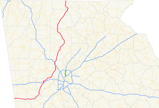
State Route 5 (SR 5) is a 155.325-mile-long (249.971 km) state highway that travels south-to-north through portions of Carroll, Douglas, Cobb, Cherokee, Pickens, Gilmer, and Fannin counties in the western and northern parts of the U.S. state of Georgia. The highway travels from its southern terminus at SR 48 at the Alabama state line, north-northwest of Ephesus, to its northern terminus at SR 60 and SR 68 at the Tennessee state line on the McCaysville–Copperhill line, bisecting the northwestern portion of the state.
Chattahoochee River National Recreation Area (CRNRA) preserves a series of sites between Atlanta and Lake Sidney Lanier along the Chattahoochee River, Georgia, U.S. The 48-mile (77 km) stretch of the river affords public recreation opportunities and access to historic sites. The National Recreation Area, a National Park Service unit, was established on August 15, 1978, by President Jimmy Carter.

The Coosawattee River is a 49.3-mile-long (79.3 km) river located in the northwestern Georgia, United States.
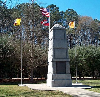
The Battle of Taliwa was fought in Ball Ground, Georgia in 1755. The battle was part of a larger campaign of the Cherokee against the Muscogee Creek people. They had 500 warriors led by Oconostota. After their victory, the Cherokees pushed the Muscogee people south from their northern Georgia homelands and began settling in the region.
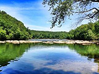
Talking Rock Creek is a stream in the northwestern Georgia, United States, that is a tributary of the Coosawattee River.
Rock Branch is an unincorporated community in Elbert County, in the U.S. state of Georgia.
Scarecorn Creek is a stream in the U.S. state of Georgia. It is a tributary to Talking Rock Creek.
Town Creek is a stream in the U.S. state of Georgia. It is a tributary to Talking Rock Creek.