

Ballal Circle, officially known as Ashoka Circle, is one of the major traffic junction in Mysore city, Karnataka state, India. [1]
Ballal Circle, officially known as Ashoka Circle, is one of the major traffic junction in Mysore city, Karnataka state, India. [1]
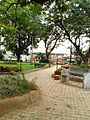
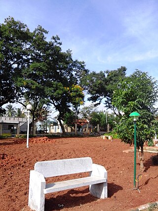
Asoka Circle is located between Kuvempunagar and Mysore Palace. [2] There is an old park near Ashoka Circle commonly called as Ganesha Park with big trees of long growth.
Vishwa Maithri Buddha Vihara Near Ashoka Circle. This is one of the Buddhist Vihara in Mysore City With a Mini Prayer Hall and Dome Shaped Exterior as you see in Buddha Viharas Across the world.
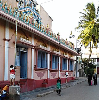
There are many temples in Asoka Circle. The oldest temple is in Krishnamurthypuram 2nd cross Aralikatte Ganapathi Temple and Guru raghavendra temple opp to Ganesha Park.


Ashoka, popularly known as Ashoka the Great, was the third Mauryan Emperor of Magadha in the Indian subcontinent during c. 268 to 232 BCE. His empire covered a large part of the Indian subcontinent, stretching from present-day Afghanistan in the west to present-day Bangladesh in the east, with its capital at Pataliputra. A patron of Buddhism, he is credited with playing an important role in the spread of Buddhism across ancient Asia.
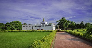
Lumbinī is a Buddhist pilgrimage site in the Rupandehi District of Lumbini Province in Nepal. It is the place where, according to Buddhist tradition, queen Maya gave birth to Siddhartha Gautama at around 566 BCE. Gautama, who, according to Buddhist tradition, achieved Enlightenment some time around 528 BCE, became Shakyamuni Buddha and founded Buddhism. Lumbini is one of many magnets for pilgrimage that sprang up in places pivotal to the life of the Buddha.
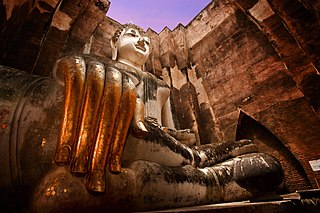
Sukhothai Historical Park covers the ruins of Sukhothai, literally 'dawn of happiness', capital of the Sukhothai Kingdom in the 13th and 14th centuries, in north central Thailand. It is near the city of Sukhothai, capital of Sukhothai Province.
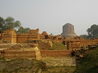
Sarnath is a place located 10 kilometres northeast of Varanasi, near the confluence of the Ganges and the Varuna rivers in Uttar Pradesh, India.
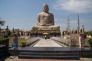
Bodh Gayā is a religious site and place of pilgrimage associated with the Mahabodhi Temple Complex, situated in the Gaya district in the Indian state of Bihar. It is famous for being the place where Gautama Buddha is said to have attained Enlightenment under what became known as the Bodhi Tree. Since antiquity, Bodh Gaya has remained the object of pilgrimage and veneration, for Hindus and Buddhists both. In particular, archaeological finds, including sculptures, show that the site was in use by Buddhists since the Mauryan period.

The Bodhi Tree, also called the Mahabodhi Tree, Bo Tree, is a large sacred fig tree located in Bodh Gaya, Bihar, India. Siddhartha Gautama, the spiritual teacher who became known as the Buddha, is said to have attained enlightenment or buddhahood circa 500 BCE under this tree. In religious iconography, the Bodhi Tree is recognizable by its heart-shaped leaves, which are usually prominently displayed.
Vihāra generally refers to a Buddhist monastery for Buddhist renunciates, mostly in the Indian subcontinent. The concept is ancient and in early Sanskrit and Pali texts, it meant any arrangement of space or facilities for dwellings. The term evolved into an architectural concept wherein it refers to living quarters for monks with an open shared space or courtyard, particularly in Buddhism. The term is also found in Ajivika, Hindu and Jain monastic literature, usually referring to temporary refuge for wandering monks or nuns during the annual Indian monsoons. In modern Jainism, the monks continue to wander from town to town except during the rainy season (chaturmasya), and the term "vihara" refers to their wanderings.
Arsikere is a city and taluka in the Hassan district in the state of Karnataka, India. It is the second largest city in Hassan district, demographically. Arsikere city municipal council consists of 35 wards. This region is known for its coconut production and is also called Kalpataru Nadu. Arsikere Junction is a major railway junction in the South Western Railway which links Mangalore and Mysore to North Karnataka and a central place for tourists who visit nearby places that do not have rail access, such as Belur, Halebidu and Shravanabelagola, Harnahalli, and Kodimata.

Chamarajanagar or Chamarajanagara is a town in the southern part of Karnataka, India. Named after Chamaraja Wodeyar IX, the erstwhile Raja of Mysore, previously known as 'Arikottara'. Chamarajanagara is the headquarters of Chamarajanagar district. It is located on the interstate highway linking the neighboring states of Tamil Nadu and Kerala.

Hajo is a historic town set in the hills northwest of Guwahati, Assam, India. It is a meeting point of Buddhists, Hindus and Muslims due to the various pilgrimage sites on the different hills of Hajo. To the Hindus, the Manikut Parbat of Hajo is the site of the 10th-century temple ruins and the 11th- to 16th-century temples complex for Vaishnavism as well as shrines of Shaivism and Shaktism. To the Buddhists, particularly from Bhutan and Tibet, Assam is where the Buddha died and the Hayagriva temple in Hajo is a part of the sacred geography of the Buddha. To the regional Muslims, the Mughal era Poa-Mecca shrine on another hill of Hajo has the tomb of Giyasuddin Aulia built in the 17th century.

The Major Rock Edicts of Indian Emperor Ashoka refer to 14 separate major Edicts of Ashoka which are significantly detailed and represent some of the earliest dated rock inscriptions of any Indian monarch. These edicts are preceded chronologically by the Minor Rock Edicts.

Ramakrishna Nagar is a residential locality in southern Mysuru, Karnataka. The inner part of the area is called the Andolana Circle or the Andolana intersection. It borders Kuvempunagar and Vivekanandanagar.
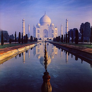
The architecture of Uttar Pradesh demonstrates a diverse and eclectic combination of Buddhist, Hindu, Indo-Islamic, and Indo-European architectural styles. Three of its architectural monuments—the Taj Mahal, the Agra Fort, as well as the township of Fatehpur Sikri founded by the Mughal emperor Akbar—are designated UNESCO World Heritage Sites. The architectural structures in Uttar Pradesh include ancient Buddhist stūpas and vihāras, ancient Buddhist and Hindu monasteries, townships, forts, palaces, temples, mosques, mausoleums, memorials, and other community structures. Uttar Pradesh's architectural structures also include various Hindu temples, Ghats, etc. largely found in ancient cities like Benares (Varanasi), Brindaban (Vrindavan), Mathura, and Prayagraj (Allahabad).
Ashokapuram is a suburb of Mysore coming on the southern side of the city. It is part of Mysore district in Karnataka state of India.
Mandi Mohalla, K.T.Street or Ashoka Road, is a suburb of Mysore city in Karnataka state of India.

Krishnaraja Boulevard is an important street of Mysore city in Karnataka state of India.
Akshaya Bhandar is a suburb of Mysore in Karnataka, India.

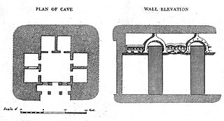
Bairat Temple is a freestanding Buddhist temple, a Chaityagriha, located about a mile southwest of the city Viratnagar, Rajasthan, India, on a hill locally called "Bijak-ki-Pahari". The temple is of a circular type, formed of a central stupa surrounded by a circular colonnade and an enclosing wall. It was built during the time of Ashoka in the 3rd century BCE, and near it were found two of Ashoka's Minor Rock Edicts, the Bairat and the Calcutta-Bairat Minor Rock Edicts. It is the earliest circular Buddhist shrine and therefore, Bairat temple is an important marker of the architecture of India.
Agrahara Circle, officially known as N. Madhava Rao Circle, is a street circle and a suburb in the southern Indian city of Mysore in Karnataka.
Agrahara is an area of the city of Mysore in the state of Karnataka in India. Famous locations in Agrahara include Mysore Palace as well as several gardens and historic temples. The area is bounded by Albert Victor Road to the North, MG Road to the South, Bengaluru-Nilgiri Road to the East, and Cheluvamba Agrahara Road to the West. The term agrahara or agraharam refers to a grant of land and agricultural income made by royalty to Brahmins in pre-independence South India. Though the Mysuru Agrahara is commonly referred to as a single neighbourhood, it is a composite of multiple adjacent smaller settlements built over time.