Ballanger Creek

Last updated

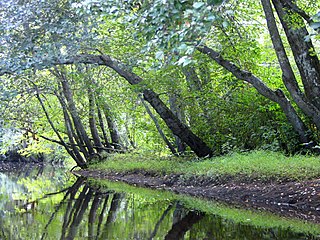
Ballanger Creek is a 4.7-mile-long (7.6 km) [1] tributary of the Mullica River in southern New Jersey in the United States. The name is derived from "Belangee," a family of French Huguenots who were early settlers in the area.

Tributary stream or river that flows into a main stem river or lake

A tributary or affluent is a stream or river that flows into a larger stream or main stem river or a lake. A tributary does not flow directly into a sea or ocean. Tributaries and the main stem river drain the surrounding drainage basin of its surface water and groundwater, leading the water out into an ocean.

Mullica River river in the United States of America

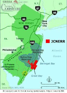
The Mullica River is a 50.6-mile-long (81.4 km) river in southern New Jersey in the United States. The Mullica was once known as the Little Egg Harbor River.

New Jersey State of the United States of America

New Jersey is a state in the Mid-Atlantic region of the Northeastern United States. It is a peninsula, bordered on the north and east by the state of New York, particularly along the extent of the length of New York City on its western edge; on the east, southeast, and south by the Atlantic Ocean; on the west by the Delaware River and Pennsylvania; and on the southwest by the Delaware Bay and Delaware. New Jersey is the fourth-smallest state by area but the 11th-most populous, with 9 million residents as of 2017, and the most densely populated of the 50 U.S. states; its biggest city is Newark. New Jersey lies completely within the combined statistical areas of New York City and Philadelphia and was the second-wealthiest U.S. state by median household income as of 2017.

Contents

It arises in Little Egg Harbor Township, New Jersey, to the west of Tuckerton, and flows south. Crossing under U.S. Route 9, it forms the boundary between Ocean County and Burlington County for the remainder of its course. Passing through abandoned cranberry bogs on the eastern side of a parcel of Bass River State Forest, it enters the tidal marshes of the Mullica, where it is fed by Lower Pasture Creek and World's End Creek. The channel of Mathis Thorofare connects it to Broad Creek to the west. Just below, it meets Fish Creek, and then the larger Winter Creek just before emptying into the Mullica.

Little Egg Harbor Township, New Jersey Township in New Jersey, United States

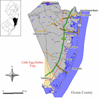
Little Egg Harbor Township is a township in Ocean County, New Jersey, United States. As of the 2010 United States Census, the township's population was 20,065, reflecting an increase of 4,120 (+25.8%) from the 15,945 counted in the 2000 Census, which had in turn increased by 2,612 (+19.6%) from the 13,333 counted in the 1990 Census. The 2010 population was the highest recorded in any decennial census.

Tuckerton, New Jersey Borough in New Jersey, United States

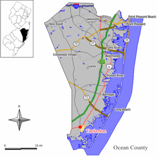
Tuckerton is a borough in Ocean County, New Jersey, United States, named for founder Ebenezer Tucker (1758–1845), and was a port of entry, but not the third Port of Entry in the United States, as is often described. As of the 2010 United States Census, the borough's population was 3,347, reflecting a decline of 170 (−4.8%) from the 3,517 counted in the 2000 Census, which had in turn increased by 469 (+15.4%) from the 3,048 counted in the 1990 Census.

U.S. Route 9 is a U.S. highway in the northeast United States, running from Laurel, Delaware north to Champlain, New York. In New Jersey, the route runs 166.80 mi (268.44 km) from the Cape May–Lewes Ferry terminal in North Cape May, Cape May County, where the ferry carries US 9 across the Delaware Bay to Lewes, Delaware, north to the George Washington Bridge in Fort Lee, Bergen County, where the route along with Interstate 95 (I-95) and US 1 continue into New York City. US 9 is the longest U.S. highway in the state. From North Cape May north to Toms River in Ocean County, US 9 is mostly a two-lane undivided road that closely parallels the Garden State Parkway and runs near the Jersey Shore. Along this stretch, it passes through the communities of Rio Grande, Cape May Court House, Somers Point, Pleasantville, Absecon, Tuckerton, Manahawkin, Beachwood and Berkeley Township. In the Toms River area, US 9 runs along the Garden State Parkway for a short distance before heading northwest away from it and the Jersey Shore into Lakewood Township. Upon entering Monmouth County, the route transitions into a multilane suburban divided highway and continues through Howell Township, Freehold Township, Manalapan Township, Marlboro Township, Old Bridge Township, Sayreville, and South Amboy. In Woodbridge Township, US 9 merges with US 1 and the two routes continue through northern New Jersey as US 1/9 to the George Washington Bridge.

Biodiversity

The rare Marsh Rattlesnake Master (Eryngium aquaticum var. aquaticum) and Pine Barren Boneset (Eupatorium resinosum) grow in the abandoned bogs along its course.

Tributaries

See also

Related Research Articles

Hackensack River river in New Jersey

The Hackensack River is a river, approximately 45 miles (72 km) long, in the U.S. states of New York and New Jersey, emptying into Newark Bay, a back chamber of New York Harbor. The watershed of the river includes part of the suburban area outside New York City just west of the lower Hudson River, which it roughly parallels, separated from it by the New Jersey Palisades. It also flows through and drains the New Jersey Meadowlands. The lower river, which is navigable as far as the city of Hackensack, is heavily industrialized and forms a commercial extension of Newark Bay. Once believed to be among the most polluted water courses in the United States, it had staged a modest revival by the late 2000s.

Barnegat Bay

Barnegat Bay is a small brackish arm of the Atlantic Ocean, approximately 42 miles (67.2 km) long, along the coast of Ocean County, New Jersey in the United States. It is separated from the Atlantic by the long Barnegat Peninsula, as well as by the north end of Long Beach Island, popular segments of the Jersey Shore. The bay is fed by several small rivers, including the Toms River and Metedeconk River, which empty into the bay through small estuaries along its inner shore. The communities of Toms River, Silverton, and Forked River sit along the river estuaries on the bay.

The Wading River is a tributary of the Mullica River, approximately 10.1 miles (16.3 km) long, in southern New Jersey in the United States. The river drains a rural forested area of the Pinelands, one of the most pristine areas along the coast of the northeastern United States.

The Bass River is a 4.7-mile-long (7.6 km) tributary of the Mullica River in southeastern New Jersey in the United States.

Great Egg Harbor River

The Great Egg Harbor River is a 55.0-mile-long (88.5 km) river in southern New Jersey in the United States. It is one of the major rivers that traverse the largely pristine Pinelands, draining 308 square miles (800 km2) of wetlands into the Atlantic Ocean at Great Egg Harbor, from which it takes its name.

Raccoon Creek is a 22.6-mile-long (36.4 km) tributary of the Delaware River in southern New Jersey in the United States.

Landing Creek is an 11.2-mile-long (18.0 km) tributary of the Mullica River in southern New Jersey in the United States. The creek originates near Egg Harbor City and joins the Mullica River just below Lower Bank near Hog Islands. It is joined along its route by Union Creek, Indian Cabin Creek, Elliot's Creek, and Rubin's Run, respectively.

Nescochague Creek is a 6.4-mile-long (10.3 km) tributary of the Mullica River in southern New Jersey in the United States. The creek starts just northwest of Hammonton, arcs along the southern boundary of Wharton State Forest, and joins the Mullica River just above County Route 542.

Batsto River river in the United States of America

The Batsto River is a 22.9-mile-long (36.9 km) tributary of the Mullica River in the southern New Jersey Pine Barrens in the United States. The river also drains 49.42 square miles of land.

West Creek is a 12.3-mile-long (19.8 km) tributary of Delaware Bay in Cape May County, New Jersey in the United States.

East Creek is a 4.8-mile-long (7.7 km) tributary of Delaware Bay in Cape May County, New Jersey in the United States.

Turtle Creek is a 1.9-mile-long (3.1 km) tributary of the Mullica River in southern New Jersey in the United States.

Big Graveling Creek is a 2.9-mile-long (4.7 km) tributary of the Mullica River in southern New Jersey in the United States.

Jacques Cousteau National Estuarine Research Reserve

The Jacques Cousteau National Estuarine Research Reserve, located in southeastern New Jersey, encompasses over 110,000 acres (450 km²) of terrestrial, wetland and aquatic habitats within the Mullica River-Great Bay Ecosystem.

Great Bay is located in southern New Jersey's Atlantic Coastal Plain in Ocean and Atlantic Counties, about ten miles (16 km) north of Atlantic City and 87 mi (140 km) south of New York City. The Mullica River flows into the bay, and together they form the Mullica River - Great Bay estuary habitat. The bay is connected to the Atlantic Ocean via the Little Egg Inlet. Great Bay is considered one of the least-disturbed marine wetlands habitats in the northeastern United States.

Hackensack RiverWalk a is partially constructed greenway along the Newark Bay and Hackensack River on the west side of the Bergen Neck peninsula in Hudson County, New Jersey. The eight-mile walkway, following the contour of the water's edge, will run between the southern tip at Bergen Point, where it may connect to the Hudson River Waterfront Walkway, and Eastern Brackish Marsh in the north. Existing parks and promenades have been incorporated and some new sections have been built, but there remain large gaps. There is a RiverWalk in the city of Hackensack, sometimes called the Hackensack RiverWalk, but they are not part of the same project nor are they connected. A parallel walkway on the west banks of the river is known as the Meadow Path.

Nestucca Bay National Wildlife Refuge

Nestucca Bay National Wildlife Refuge is a U.S. National Wildlife Refuge on Oregon's coast. It lies in southern Tillamook County, on the state's northern coast. It is one of six National Wildlife Refuges comprising the Oregon Coast National Wildlife Refuge Complex and supports one tenth of the world's dusky Canada goose population. The refuge contains at least seven types of habitat, including tidal marsh, tidal mudflats, grassland, woodland, pasture, forested lagg—a transition between raised peat bog and mineral soil—and freshwater bogs, including the southernmost coastal Sphagnum bog habitat on the Pacific Coast.

Chewaucan River river in the United States of America

The Chewaucan River is part of the Great Basin drainage. It flows 53 miles (85 km) through the Fremont–Winema National Forests, Bureau of Land Management land, and private property in southern Oregon. Its watershed consists of 651 square miles (1,690 km2) of conifer forest, marsh, and rural pasture land. The river provides habitat for many species of wildlife including native Great Basin redband trout a subspecies of rainbow trout.

Green Creek, New Jersey Unincorporated community in New Jersey, United States

Green Creek is an unincorporated community located within Middle Township, in Cape May County, New Jersey, United States. It is located on Route 47. It is a very low-lying area with a highest elevation of just above 20 feet (6.1 m). The community is located about 3 miles (4.8 km) west of Rio Grande and about 2 miles (3.2 km) from the Delaware Bay. It is mostly residential with areas of agriculture and commerce along the main road, Delsea Drive. The United States Postal Service ZIP Code is 08219.

References

  1. U.S. Geological Survey. National Hydrography Dataset high-resolution flowline data. The National Map Archived 2012-04-05 at WebCite , accessed April 1, 2011

Coordinates: 39°33′35″N74°24′58″W / 39.55984°N 74.415982°W / 39.55984; -74.415982

Geographic coordinate system Coordinate system

A geographic coordinate system is a coordinate system that enables every location on Earth to be specified by a set of numbers, letters or symbols. The coordinates are often chosen such that one of the numbers represents a vertical position and two or three of the numbers represent a horizontal position; alternatively, a geographic position may be expressed in a combined three-dimensional Cartesian vector. A common choice of coordinates is latitude, longitude and elevation. To specify a location on a plane requires a map projection.