Related Research Articles

The Northwest Passage (NWP) is the sea lane between the Atlantic and Pacific oceans through the Arctic Ocean, along the northern coast of North America via waterways through the Arctic Archipelago of Canada. The eastern route along the Arctic coasts of Norway and Siberia is accordingly called the Northeast Passage (NEP). The various islands of the archipelago are separated from one another and from Mainland Canada by a series of Arctic waterways collectively known as the Northwest Passages, Northwestern Passages or the Canadian Internal Waters.

Hudson Strait in Nunavut links the Atlantic Ocean and the Labrador Sea to Hudson Bay in Canada. This strait lies between Baffin Island and Nunavik, with its eastern entrance marked by Cape Chidley in Newfoundland and Labrador and Nunavut and Resolution Island, off Baffin Island. The strait is about 750 km (470 mi) long with an average width of 125 km (78 mi), varying from 70 km (43 mi) at the eastern entrance to 240 km (150 mi) at Deception Bay.

Ellesmere Island is Canada's northernmost and third largest island, and the tenth largest in the world. It comprises an area of 196,236 km2 (75,767 sq mi), slightly smaller than Great Britain, and the total length of the island is 830 km (520 mi).

Victoria Island is a large island in the Arctic Archipelago that straddles the boundary between Nunavut and the Northwest Territories of Canada. It is the eighth-largest island in the world, and at 217,291 km2 (83,897 sq mi)1 in area, it is Canada's second-largest island. It is nearly double the size of Newfoundland (111,390 km2 [43,010 sq mi]), and is slightly larger than the island of Great Britain (209,331 km2 [80,823 sq mi]) but smaller than Honshu (225,800 km2 [87,200 sq mi]). The western third of the island lies in the Inuvik Region of the Northwest Territories; the remainder is part of Nunavut's Kitikmeot Region. The population of 2,168 is divided between two settlements, the larger of which is Cambridge Bay (Nunavut) and the other Ulukhaktok.

The Gulf of St. Lawrence fringes the shores of the provinces of Quebec, New Brunswick, Nova Scotia, Prince Edward Island, Newfoundland and Labrador, in Canada, plus the islands Saint-Pierre and Miquelon, possessions of France, in North America.

The Arctic Archipelago, also known as the Canadian Arctic Archipelago, is an archipelago lying to the north of the Canadian continental mainland, excluding Greenland and Iceland.

Baffin Bay, located between Baffin Island and the west coast of Greenland, is defined by the International Hydrographic Organization as a marginal sea of the Arctic Ocean. It is sometimes considered a sea of the North Atlantic Ocean. It is connected to the Atlantic via Davis Strait and the Labrador Sea. The narrower Nares Strait connects Baffin Bay with the Arctic Ocean. The bay is not navigable most of the year because of the ice cover and high density of floating ice and icebergs in the open areas. However, a polynya of about 80,000 km2 (31,000 sq mi), known as the North Water, opens in summer on the north near Smith Sound. Most of the aquatic life of the bay is concentrated near that region.

The Davis Strait is a southern arm of the Arctic Ocean that lies north of the Labrador Sea. It lies between mid-western Greenland and Baffin Island in Nunavut, Canada. To the north is Baffin Bay. The strait was named for the English explorer John Davis (1550–1605), who explored the area while seeking a Northwest Passage. By the 1650s it was used for whale hunting.

The Labrador Sea is an arm of the North Atlantic Ocean between the Labrador Peninsula and Greenland. The sea is flanked by continental shelves to the southwest, northwest, and northeast. It connects to the north with Baffin Bay through the Davis Strait. It is a marginal sea of the Atlantic.

The Greenland Sea is a body of water that borders Greenland to the west, the Svalbard archipelago to the east, Fram Strait and the Arctic Ocean to the north, and the Norwegian Sea and Iceland to the south. The Greenland Sea is often defined as part of the Arctic Ocean, sometimes as part of the Atlantic Ocean. However, definitions of the Arctic Ocean and its seas tend to be imprecise or arbitrary. In general usage the term "Arctic Ocean" would exclude the Greenland Sea. In oceanographic studies the Greenland Sea is considered part of the Nordic Seas, along with the Norwegian Sea. The Nordic Seas are the main connection between the Arctic and Atlantic oceans and, as such, could be of great significance in a possible shutdown of thermohaline circulation. In oceanography the Arctic Ocean and Nordic Seas are often referred to collectively as the "Arctic Mediterranean Sea", a marginal sea of the Atlantic.

Fury and Hecla Strait is a narrow Arctic seawater channel located in the Qikiqtaaluk Region of Nunavut, Canada.

Valdes Island is one of the Gulf Islands located in the Strait of Georgia, British Columbia, Canada. It is across Porlier Pass from Galiano Island, which lies to the southeast. It has an area of 23 square kilometres, and is 1.6 kilometres wide by 16 kilometres in length. The island is popular with kayakers, boaters and has historically been the site of several human settlements.

Murchison Promontory, a cape (promontory) in the northern Canadian Arctic, is the northernmost mainland point of the Americas and of Canada. Located 1,087 nautical miles from the North Pole, it is 64 km (40 mi) farther north than Point Barrow, Alaska, the northernmost point of all U.S. territory.
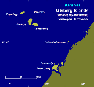
The Heiberg Islands, spelt Geyberg, Gejberg or Geiberg is a group of four small islands covered with tundra vegetation and with scattered stones on their shores. They lie in the Kara Sea, between the bleak coast of Siberia's Taymyr Peninsula and Severnaya Zemlya. These islands are between 35 and 45 km from the continental shore.

Franklin's lost expedition was a failed British voyage of Arctic exploration led by Captain Sir John Franklin that departed England in 1845 aboard two ships, HMS Erebus and HMS Terror, and was assigned to traverse the last unnavigated sections of the Northwest Passage in the Canadian Arctic and to record magnetic data to help determine whether a better understanding could aid navigation. The expedition met with disaster after both ships and their crews, a total of 129 officers and men, became icebound in Victoria Strait near King William Island in what is today the Canadian territory of Nunavut. After being icebound for more than a year Erebus and Terror were abandoned in April 1848, by which point two dozen men, including Franklin, had died. The survivors, now led by Franklin's second-in-command, Francis Crozier, and Erebus's captain, James Fitzjames, set out for the Canadian mainland and disappeared, presumably having perished.

The bowhead whale is a species of baleen whale belonging to the family Balaenidae and is the only living representative of the genus Balaena. It is the only baleen whale endemic to the Arctic and subarctic waters, and is named after its characteristic massive triangular skull, which it uses to break through Arctic ice. Other common names of the species included the Greenland right whale, Arctic whale, steeple-top, and polar whale.
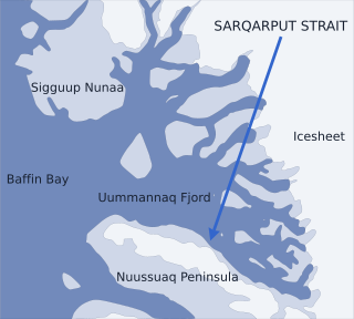
Sarqarput Strait is a strait in the Uummannaq Fjord system in northwestern Greenland. It separates Uummannaq Island in the northeast from Nuussuaq Peninsula in the southwest. The strait waterway is part of the southern arm of Uummannaq Fjord, narrowing into Ikerasak Fjord in the southeast, at the base of Nuussuaq Peninsula. The Sarfaagfip Kussinnersua and Kuuk rivers flowing from the peninsular glaciers empty into the strait.

The borders of the oceans are the limits of Earth's oceanic waters. The definition and number of oceans can vary depending on the adopted criteria. The principal divisions of the five oceans are the Pacific Ocean, Atlantic Ocean, Indian Ocean, Southern (Antarctic) Ocean, and Arctic Ocean. Smaller regions of the oceans are called seas, gulfs, bays, straits, and other terms. Geologically, an ocean is an area of oceanic crust covered by water.

The Canadian Arctic Rift System is a major North American geological structure extending from the Labrador Sea in the southeast through Davis Strait, Baffin Bay and the Arctic Archipelago in the northwest. It consists of a series of interconnected rifts that formed during the Paleozoic, Mesozoic and Cenozoic eras. Extensional stresses along the entire length of the rift system have resulted in a variety of tectonic features, including grabens, half-grabens, basins and faults.

The Judge Daly Promontory is a peninsula located on the eastern coast of Ellesmere Island, a part of the Qikiqtaaluk Region of the Canadian territory of Nunavut. It stretches from the southwest northeastward into Nares Strait. Lady Franklin Bay is to the north, Archer Fiord to the west, and Cape Baird is its northernmost point.
References
- ↑ "Vessel details for: BALLANTYNE STRAITS (Tug) - IMO 7391977, MMSI 316005605, Call Sign CZ5836 Registered in Canada - AIS Marine Traffic". MarineTraffic.com. Retrieved October 4, 2018.
- ↑ "Ballantyne Strait, Canada - Geographical Names, map, geographic coordinates". geographic.org. Retrieved October 4, 2018.
77°40′N115°15′W / 77.667°N 115.250°W
| | This Canadian Northwest Territories location article is a stub. You can help Wikipedia by expanding it. |