
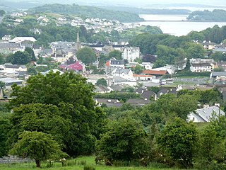
Bundoran is a town in County Donegal, Ireland. The town is located near the N15 road near Ballyshannon, and is the most southerly town in Donegal. The town is a tourist seaside resort, and tourism has been at the heart of the local economy since the 18th century. Bundoran is a surfing destination and was listed by National Geographic magazine in 2012 as one of the world's top 20 surf towns.
Donegal is a town in County Donegal in Ulster, the northern province in Ireland. Although Donegal gave its name to the county, now Lifford is the county town. From the 15th until the early 17th century, Donegal was the "capital" of Tyrconnell, a Gaelic kingdom controlled by the O'Donnell dynasty of the Northern Uí Néill.

Árainn Mhór is an island off the west coast of County Donegal in Ulster, the northern province in Ireland. Arranmore is the largest inhabited island of County Donegal, with a population of 478 in 2022, but has had a gradually falling native population since the 1990s. Its main settlement is Leabgarrow. The island is part of the Gaeltacht, with most of the inhabitants speaking Ulster Irish.

Stranorlar is a town, townland and civil parish in the Finn Valley of County Donegal, in Ireland. Stranorlar and Ballybofey form the twin towns of Ballybofey–Stranorlar.

Sligo–Leitrim is a parliamentary constituency that has been represented in Dáil Éireann, the lower house of the Irish parliament or Oireachtas, from the 2016 general election. The constituency elects 4 deputies on the system of proportional representation by means of the single transferable vote (PR-STV). Another constituency of the same name existed from 1948 to 2007.

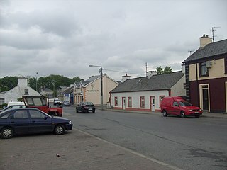
Ballintra is a village in the parish of Drumholm in the south of County Donegal, Ireland, just off the N15 road between Donegal town and Ballyshannon. Ballintra lies on the northern bank of the Blackwater river. The river rises in the hills that lie inland from the town, and flows through a number of small lakes before spilling over a small waterfall in a gorge behind the village.
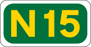
The N15 road is a national primary road in the north-west of Ireland. It runs from Sligo to Lifford, County Donegal. It forms part of the proposed Atlantic Corridor route. It also goes to the border with Northern Ireland.
Convoy is a village and civil parish in the east of County Donegal, Ireland. The village is located in the Finn Valley district and is part of the Barony of Raphoe South. It is situated on the Burn Dale, and is located on the R236 road to Raphoe.
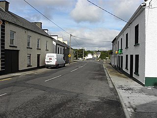
Laghy or Laghey is a village and townland in County Donegal, Ireland, between Ballintra and Donegal Town. It is one of three villages that make up the parish of Drumholm, formerly a civil and Church of Ireland parish, now only used as a division of the Roman Catholic Diocese of Raphoe. The village has a quarry, a supermarket, garden centre, filling station, two public houses, a church with a graveyard, an Orange hall, a recycling centre, a Donegal County Council yard and salt depot, and a national school. Rossnowlagh and Murvagh beaches are nearby. Murvagh is also the home to Donegal Golf Club.

Donegal is a parliamentary constituency which has been represented in Dáil Éireann, the lower house of the Irish parliament or Oireachtas, since the 2016 general election. The constituency elects 5 deputies on the system of proportional representation by means of the single transferable vote (PR-STV).
Donegal–Leitrim was a parliamentary constituency represented in Dáil Éireann, the lower house of the Irish parliament or Oireachtas from 1969 to 1977. The constituency elected 3 deputies to the Dáil, on the system of proportional representation by means of the single transferable vote (PR-STV).

Rossnowlagh is a seaside village in the south of County Donegal, Ireland. It is about 8 kilometres (5 mi) north of Ballyshannon and 16 km (10 mi) southwest of Donegal Town. The area's 3 km (2 mi) long beach, or 2 km (1.2 mi) if measuring from the cliffs to Carrickfad, is frequented by walkers, surfers, windsurfers, kite-surfers and swimmers.
Donegal West was a parliamentary constituency represented in Dáil Éireann, the lower house of the Irish parliament or Oireachtas from 1937 to 1961. The constituency elected 3 deputies to the Dáil, on the system of proportional representation by means of the single transferable vote (PR-STV).

The Parish of Drumholm is a parish in the Roman Catholic Diocese of Raphoe. It is also a civil parish, with the variant spelling of Drumhome, in the barony of Tirhugh, County Donegal in Ireland. The parish contains all the land between the large towns of Ballyshannon and Donegal Town, including the small villages of Laghey, Ballintra and Rossnowlagh and the hamlet of Bridgetown. The parish has two Catholic primary schools: St Ernan's National School in Ballintra and St Eunan's National School in Laghey. The current parish priest is Fr Seamus Dagens, who succeeded Fr Daniel McBrearty in 2007. Drumholm is also a parish for the Church of Ireland and a civil parish.

Bruckless is a tiny village in southwest County Donegal, Ireland, with a population of around 69. It lies on the N56 national secondary road which links it to Donegal Town 20 km east and to Killybegs 7 km west. The village overlooks McSwyne's Bay, an inlet in Donegal Bay. Bruckless is part of the Roman Catholic parish of Killaghtee and the diocese of Raphoe. In the Church of Ireland, it is covered by the parish of Inver and the diocese of Derry and Raphoe.
Thomas Howard Morrow was an Australian politician.
The Donegal Railway Company (DR) was a 3 ft gauge railway in Ireland.

The R231 road is a regional road in Ireland. It is a loop road from the N15 road in County Donegal. Most of the road is part of the Wild Atlantic Way.
St Naul's is a Gaelic football club in the parish of Inver in County Donegal, Ireland.
CLG Naomh Bríd is a Gaelic football club in the south of County Donegal, Ireland. Several of the club's players have been involved with the Donegal county team.