Ballintra

Last updated

Ballintra
Baile an tSratha
Village
Ballintra.JPG
Ballintra's main street
Ireland adm location map.svg
Red pog.svg
Ballintra
Location in Ireland
Coordinates: 54°34′30″N8°07′24″W / 54.5749°N 8.1234°W / 54.5749; -8.1234
CountryIreland
Province Ulster
County County Donegal
Population
 (2016) [1]
191
Time zone UTC+0 (WET)
  Summer (DST) UTC-1 (IST (WEST))
Irish Grid Reference G917700

Ballintra (Irish : Baile an tSratha) [2] is a village in the parish of Drumholm in the south of County Donegal, Ireland, just off the N15 road between Donegal town and Ballyshannon. Ballintra lies on the northern bank of the Blackwater river (sometimes referred to as the Ballintra River). [3] The river rises in the hills that lie inland from the town, and flows through a number of small lakes before spilling over a small waterfall in a gorge behind the village.[ citation needed ]

Contents

The Irish meaning of Ballintra, Baile an tSratha, means town by the low-lying land along a river, the village is situated close to Rossnowlagh and Murvagh beaches.

The village is situated in a limestone area, and there are a number of quarries in the area. [4]

History

Built heritage

Evidence of prehistoric settlement in the area include a number of ringforts (for example in nearby Moneymore townland) and a megalithic wedge tomb (in Ballymagrorty townland). [5]

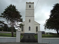
Much of the village itself was laid-out in the late 18th and early 19th century, with the town's bridges dating from the 1780s and 1790s, [6] [7] and Ballintra's Anglican, Catholic and Methodist churches dating to 1795, 1845 and 1896 respectively. [8] [9] [10]

Irish language decline

The 1911 census records only a handful of people in Ballintra who were Irish speakers. In his paper "Irish Speaking in the Pre-famine Period", Dr. Garret Fitzgerald remarks that "near Ballintra the language seems to have disappeared by the time of the Famine. Around Ballyshannon it also seems to have been almost extinct". [11] As late as 1960, up to a few dozen native Irish speakers remained in Tamhnach a' Mhullaigh (known in English as Townawilly or Tawnawully). The Irish scholar and campaigner Máirtín Ó Cadhain visited the area in 1957 to record folklore stories in Irish from a family in the area.[ citation needed ]

Developments

The 2016 census indicates that approximately 35% of homes in Ballintra were built in the early 20th century or prior, with a further peak in building (20% of homes) built in the 1970s. [1] The latter includes a number of social housing units built by Donegal County Council in the 1970s.[ citation needed ] Other developments include a bypass road built in the early 1980s.[ citation needed ]

In the 20 years between the 1996 and the 2016 census, the population of the village decreased by 12%, from 217 to 191 residents. [1] [12]

Amenities

Ballintra Church of Ireland Church of Ireland, Ballintra - geograph.org.uk - 913408.jpg
Ballintra Church of Ireland
Ballintra Roman Catholic church Ballintrachurch.JPG
Ballintra Roman Catholic church

Ballintra has one public house, a grocery store, a takeaway, a hairdresser, two primary schools (St. Ernan's NS and The Robertson NS), [13] and three churches (Methodist, Church of Ireland, and Roman Catholic). [10] [8] [9]

Sport

The Ballintra Races is an annual horse race run on a field close to the nearby Murvagh beach. [14] Proceeds from the event go to support amenities in the area. [15]

The local Gaelic Athletic Association club is called Naomh Bríd (a club which also takes players from Laghey). [16] The local association football (soccer) club is called Copany Rovers (and also represents Laghey).[ citation needed ]

Transport

Ballintra railway station opened on 21 September 1905, but finally closed on 1 January 1960. [17] The station was on the County Donegal Railways Joint Committee network.

By road, Ballintra lies just off the N15 national primary route from Lifford to Sligo.

People

See also

Related Research Articles

<span class="mw-page-title-main">Castlepollard</span> Village in County Westmeath, Ireland

Castlepollard is a village in north County Westmeath, Republic of Ireland. It lies west of Lough Lene and northeast of Lough Derravaragh and Mullingar.

<span class="mw-page-title-main">Gorey</span> Town in County Wexford, Ireland

Gorey is a market town in north County Wexford, Ireland. It is bypassed by the main M11 Dublin to Wexford road. The town is also connected to the railway network along the same route. Local newspapers include the Gorey Guardian.

<span class="mw-page-title-main">Riverstown</span> Village in County Sligo, Ireland

Riverstown, historically called Ballyederdaowen, is a village in County Sligo, Ireland. Known for its musical tradition it is located at a bridging point of the River Unshin (Arrow), 17.2 km south of Sligo town and 4 km east of the N4 road.

<span class="mw-page-title-main">Rosmuc</span> Village in County Galway, Ireland

Rosmuc or Ros Muc, sometimes anglicised as Rosmuck, is a village in the Conamara Gaeltacht of County Galway, Ireland. It lies halfway between the town of Clifden and the city of Galway. Irish is the predominant spoken language in the area, with the electoral division of Turlough, Rosmuc, representing one of the highest percentages of Irish-speaking people in the country. The townland of Rosmuck is part of the civil parish of Kilcummin.

<span class="mw-page-title-main">Laghy</span> Village in County Donegal, Ireland

Laghy or Laghey is a village and townland in County Donegal, Ireland, between Ballintra and Donegal Town. It is one of three villages that make up the parish of Drumholm, formerly a civil and Church of Ireland parish, now only used as a division of the Roman Catholic Diocese of Raphoe. The village has a quarry, a supermarket, garden centre, filling station, two public houses, a church with a graveyard, an Orange hall, a recycling centre, a Donegal County Council yard and salt depot, and a national school. Rossnowlagh and Murvagh beaches are nearby. Murvagh is also the home to Donegal Golf Club.

<span class="mw-page-title-main">Ballingarry, County Limerick</span> Village in County Limerick, Ireland

Ballingarry is a village in County Limerick, Ireland. It is located near the village of Granagh and between the towns of Rathkeale and Kilmallock on the R518 road. Ballingarry lies in a civil parish of the same name, and within the ecclesiastical parish of Ballingarry-Granagh in the Roman Catholic Diocese of Limerick. The village had a population of 570 as of the 2022 census, up from 521 at the 2016 census.

<span class="mw-page-title-main">Quigley's Point</span> Village in County Donegal, Ireland

Quigley's Point is a village in County Donegal, Ireland. Located on the eastern shores of Inishowen and overlooking Lough Foyle, the village is sometimes known locally as "Carrowkeel" as it is in a townland of that name. To the south is the city of Derry and to the north lie the villages of Moville and Greencastle. A car ferry links Greencastle with Magilligan during the summer. The river Cabry, which flows through the area, is spanned by a late-18th century bridge at Quigley's Point.

<span class="mw-page-title-main">Drumholm</span> Parish in County Donegal, Ireland

The Parish of Drumholm is a parish in the Roman Catholic Diocese of Raphoe. It is also a civil parish, with the variant spelling of Drumhome, in the barony of Tirhugh, County Donegal in Ireland. The parish contains all the land between the large towns of Ballyshannon and Donegal Town, including the small villages of Laghey, Ballintra and Rossnowlagh and the hamlet of Bridgetown. The parish has two Catholic primary schools: St Ernan's National School in Ballintra and St Eunan's National School in Laghey. The current parish priest is Fr Seamus Dagens, who succeeded Fr Daniel McBrearty in 2007. Drumholm is also a parish for the Church of Ireland and a civil parish.

<span class="mw-page-title-main">Knockbride</span> Parish in County Cavan, Ireland

Knockbride is a civil parish in County Cavan, Ireland. It is located to the north of the town of Bailieborough.

<span class="mw-page-title-main">Ballintra, Arranmore</span>

Baile an tSratha is a townland on the Gaeltacht island of Arranmore in County Donegal, Ireland. Translated to the English language, Ballintra means "road to the beach". The townland is in the historic barony of Boylagh.

<span class="mw-page-title-main">Ballindrait</span> Village in County Donegal, Ireland

Ballindrait is a townland, village and census town in County Donegal, Ireland. Located near Lifford, the village and townland of Ballindrait is in the civil parish of Clonleigh and the barony of Raphoe North. The Burn Dale flows through the centre of Ballindrait.

Staplestown is a village and townland in north County Kildare, Ireland, located 40 kilometres west of Dublin. The village has a church, a school and is home to St Kevin's GAA. The local national (primary) school is Scoil Naomh Mhuire National School.

<span class="mw-page-title-main">Johnstownbridge</span> Village in Leinster, Ireland

Johnstownbridge is a commuter town located in north County Kildare, Ireland. It lies in the parish of Cadamstown, in the district of Balyna, and barony of Carbury. It is located on the R402 road between Enfield and Edenderry just off the M4 motorway. As of the 2016 census, Johnstownbridge had a population of 683 people, up from 211 in the 2002 census.

<span class="mw-page-title-main">Ballingarry, North Tipperary</span> Civil parish in County Tipperary, Ireland

Ballingarry is a civil parish and a townland in the barony of Ormond Lower, County Tipperary in Ireland. It is located on the N52 between Borrisokane and Birr. Ballingarry townland has an area of 5.3 square kilometres (2 sq mi), and had a population of 170 people as of the 2011 census.

<span class="mw-page-title-main">Carrick, County Donegal</span> Village in County Donegal, Ireland

Carrick is a village located within the civil parish of Glencolmcille in County Donegal, Ireland. As of the 2016 census, the population of the village was 265. Carrick is located between neighbouring towns Glencolmcille, Meenanary, Teelin and Kilcar. Nearby is Sliabh Liag, the highest sea cliff in Europe.

<span class="mw-page-title-main">Castlejordan, County Meath</span> Village in County Meath, Ireland

Castlejordan is a village and townland in County Meath, Ireland. It is located in the south of the county, close to the border with County Offaly, to the south of Kinnegad. The townland of Castlejordan has an area of approximately 2.2 square kilometres (0.85 sq mi), and had a population of 85 people as of the 2011 census.

CLG Naomh Bríd is a Gaelic football club in the south of County Donegal, Ireland. Several of the club's players have been involved with the Donegal county team.

<span class="mw-page-title-main">Robinstown, County Meath</span> Village in County Meath, Ireland

Robinstown, in the townland of Balbradagh, is a village in County Meath, Ireland.

Ballyhahill is a village and townland in County Limerick, Ireland. As of the 2016 census, the village had a population of 146 people. It is 40 km west of Limerick city. The White River flows to the east of the village.

<span class="mw-page-title-main">Ballinameen</span> Village in Connacht, Ireland

Ballinameen is a small village and census town in County Roscommon, Ireland. Located in the historical barony of Frenchpark on the R370 regional road, the village had a population of 191 people as of the 2016 census.

References

  1. 1 2 3 "Sapmap Area - Settlements - Ballintra". Census 2016. Central Statistics Office. April 2016. Retrieved 4 June 2018.
  2. "Baile an tSratha/Ballintra". logainm.ie. Placenames Database of Ireland . Retrieved 22 February 2022.
  3. "Abhainn Bhaile an tSratha / Ballintra River". Logainm.ie. Irish Placenames Commission. Retrieved 26 October 2018.
  4. "Report on Ballintra cSAC (candidate Special Area of Conservation)" (PDF). npws.ie. National Parks and Wildlife Service. 2006. Retrieved 26 October 2018.
  5. "Recorded Monuments Protected under Section 12 of the National Monuments (Amendment) Act - County Donegal" (PDF). archaeology.ie. National Monuments Service. 1996. Retrieved 1 September 2020.
  6. "Ballintra Bridge, Ballintra, County Donegal". buildingsofireland.ie. National Inventory of Architectural Heritage. Retrieved 1 September 2020.
  7. "Bridge, Ballintra, County Donegal". buildingsofireland.ie. National Inventory of Architectural Heritage. Retrieved 1 September 2020.
  8. 1 2 "Ballintra Church of Ireland, Ballintra, County Donegal". buildingsofireland.ie. National Inventory of Architectural Heritage. Retrieved 1 September 2020.
  9. 1 2 "St. Bridget's Catholic Church, Ballintra, County Donegal". buildingsofireland.ie. National Inventory of Architectural Heritage. Retrieved 1 September 2020.
  10. 1 2 "Ballintra Methodist Church, Main Street, Ballintra, County Donegal". buildingsofireland.ie. National Inventory of Architectural Heritage. Retrieved 1 September 2020.
  11. Fitzgerald, Garret (2003). "Irish-Speaking in the Pre-Famine Period: A Study Based on the 1911 Census Data for People Born before 1851 and Still Alive in 1911". Proceedings of the Royal Irish Academy: Archaeology, Culture, History, Literature. 103C (5): 191–283. doi:10.3318/PRIC.2003.103.1.191. JSTOR   25506198.
  12. "Ballintra (Ireland) Census Town". citypopulation.de. Retrieved 1 September 2020.
  13. "Robertson National School website". robertson.ie. Robertson NS. Retrieved 26 October 2018.
  14. "Fantastic day of racing on the cards at the Ballintra Races". donegaldemocrat.ie. Donegal Democrat. 6 August 2017. Retrieved 26 October 2018.
  15. "Ballintra / Laghey Notes". donegaldemocrat.ie. Donegal Democrat. 23 July 2009. Archived from the original on 1 August 2012.
  16. "Naomh Bríd Club Location". naomhbrid.ie. Naomh Bríd GAA Club. Archived from the original on 16 September 2018. Retrieved 26 October 2018.
  17. "Ballintra station" (PDF). Railscot - Irish Railways. Archived (PDF) from the original on 26 September 2007. Retrieved 10 September 2007.
  18. "St Asicus". elphindiocese.ie. Elphin Diocese. Retrieved 26 October 2018.
  19. "Obituary: The Rev Leonard Boyle". The Independent. 2 November 1999. Retrieved 26 October 2018.
  20. "Gallagher, Matt". hoganstand.com. Hogan Stand. 17 July 1992. Retrieved 20 February 2019.
  21. "Mr Thomas Howard Morrow (1888-1971)". Former members of the Parliament of New South Wales . Retrieved 23 June 2019.
  22. "Donegal Players Profile". The Kerryman. Independent News & Media. 17 September 2014 via pressreader.com. David Walsh [,] The Ballintra native, who was once on Luton Town's books, first appeared for Donegal as a 25-year-old