Áine is an Irish goddess of summer, wealth and sovereignty. She is associated with midsummer and the sun, and is sometimes represented by a red mare. She is the daughter of Egobail, the sister of Aillen and/or Fennen, and is claimed as an ancestor by multiple Irish families. As the goddess of love and fertility, she has command over crops and animals and is also associated with agriculture.

Dunfanaghy is a small town, former fishing port, and commercial centre on the north coast of County Donegal, Ireland. It lies on Donegal's North West coast, specifically the west side of Sheephaven Bay, on the N56 road.
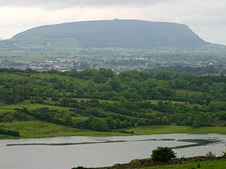
Knocknarea is a large prominent hill west of Sligo town in County Sligo, Ireland, with a height of 327 metres (1,073 ft). Knocknarea is visually striking as it has steep limestone cliffs and stands on the Cúil Irra peninsula overlooking the Atlantic coast. At the summit is one of Ireland's largest cairns, known as Queen Maeve's Cairn, which is believed to contain a Neolithic passage tomb. In recent years there has been concern that the ancient cairn, a protected National Monument, is being damaged by climbers. There are also remains of several smaller tombs on the summit. Knocknarea overlooks the Carrowmore tombs and is thought to have been part of an ancient ritual landscape.

Knockmealdown is the highest peak of the Knockmealdown Range of mountains, located on the border between Co Tipperary and Co Waterford.
Torrin is a settlement on the island of Skye in Scotland.

Donald's Hill, or Knocknahurkle, is a hill in County Londonderry, Northern Ireland. The summit is 399 metres (1,309 ft) above sea level and classifies it as a Marilyn. It is part of the Keenaght Hills and overlooks the village of Drumsurn.

Cnoc na Péiste, anglicised Knocknapeasta, at 988 metres (3,241 ft), is the fourth-highest peak in Ireland, on the Arderin and Vandeleur-Lynam lists. Cnoc na Péiste is part of the MacGillycuddy's Reeks range in County Kerry. It is one of only two 3,000 ft peaks in the Reeks with a prominence above the Marilyn threshold of 150 metres, and is the highest summit of the Eastern Reeks. In 1943, a USAAF plane crashed into the mountain, killing all five crew, and parts of the wreckage can still be seen in Lough Cummeenapeasta.

Sheephaven Bay or Sheep Haven is a broad, shallow inlet on the north coast of County Donegal, Ireland. Bounded by the peninsulae of Rosguill, to the east and Horn Head to the west, the bay is relatively protected from the full force of the Atlantic Ocean, and has supported a vibrant herring fleet.

Brandon Hill is the highest mountain in County Kilkenny, Ireland, with an elevation of 515 m (1,690 ft) and prominence at 448 m (1,470 ft). The South Leinster Way, a long-distance trail, meandering through the Barrow Valley and traverses Brandon Hill. The village of Graiguenamanagh and River Barrow are at the base of the hill. It is classified as a county high point, an Arderin, a Myrddyn Dewey, and a Marilyn.

Knocklong is a small village situated in County Limerick, Ireland, located on the main Limerick to Mitchelstown to Cork road. The population was 256 at the 2016 census.

Arbour Hill is an area of Dublin within the inner city on the Northside of the River Liffey, in the Dublin 7 postal district. Arbour Hill, the road of the same name, runs west from Blackhall Place in Stoneybatter, and separates Collins Barracks, now hosting part of the National Museum of Ireland, to the south from Arbour Hill Prison to the north, whose graveyard includes the burial plot of the signatories of the Easter Proclamation and other leaders executed after the 1916 Rising. St Bricin's Military Hospital, formerly the King George V Hospital, is also located in Arbour Hill.

Spancill Hill or Spancilhill is a hill and adjacent dispersed settlement in County Clare, Ireland. The historic hamlet of Spancilhill was by the fair green, which is still the site of the Spancill Hill Fair, which occurs annually on 23 June. Houses are concentrated slightly south at Cross of Spancilhill, where the R352 road between Ennis to the west and Tulla to the east crosses a local road between Barefield to the north and Quin to the south.

Knocknadobar at 690 metres (2,260 ft), is the 102nd–highest peak in Ireland on the Arderin scale, and the 123rd–highest peak in Ireland according to the Vandeleur-Lynam scale. Knocknadobar is one of the main mountains of the Iveragh Peninsula in County Kerry, Ireland, and has been one of the most important sites of pilgrimage in Ireland since medieval times.

Cnoc an Chuillinn, at 958 metres (3,143 ft), is the sixth-highest peak in Ireland on the Arderin list and the seventh-highest peak in Ireland on the Vandeleur-Lynam list. The name is sometimes incorrectly anglicised to Knockacullion, which is a name used for peaks and townlands in other parts of Ireland. Cnoc an Chuillinn is part of the MacGillycuddy's Reeks range in County Kerry.

Carhoo Hill or Ballymacadoyle Hill is a large hill south-west of Dingle in County Kerry, Ireland.

Knockanore Mountain is a large hill North Kerry, Ireland.

Neil McBride was a farmer, poet, author, and songwriter from Feymore, Creeslough, Donegal, Ireland, who further gained notoriety for protesting a fine he received for having his name written in Irish on his business cart.

Cnoc na Toinne, at 845 metres (2,772 ft), is the 17th-highest peak in Ireland on the Arderin list, and the 23rd-highest peak in Ireland on the Vandeleur-Lynam list. It is part of the MacGillycuddy's Reeks range in County Kerry. Cnoc na Toinne lies between the Coomloughra Reeks and the Eastern Reeks, and is just above the col of the Devil's Ladder, a popular route for climbing Carrauntoohil, Ireland's highest mountain.

Lissoughter at 401 metres (1,316 ft), does not qualify to be an Arderin or a Vandeleur-Lynam, however, its prominence of 336 metres (1,102 ft) ranks it as a Marilyn. Lissoughter is an isolated peak, situated between the Twelve Bens and Maumturks mountain ranges, at the southern entrance to the Inagh Valley, in the Connemara National Park, in Recess, County Galway, Ireland.

