
Ardagh is a townland in the fertile district known as the Laggan in East Donegal, part of County Donegal, Ireland. It is very near St Johnston. It became part of the large Abercorn Estate and was settled by mainly Lowland Scots settlers during the Plantation of Ulster.

Quigley's Point is a village in County Donegal, Ireland. Located on the eastern shores of Inishowen and overlooking Lough Foyle, the village is sometimes known locally as "Carrowkeel" as it is in a townland of that name. To the south is the city of Derry and to the north lie the villages of Moville and Greencastle. A car ferry links Greencastle with Magilligan during the summer. The river Cabry, which flows through the area, is spanned by a late-18th century bridge at Quigley's Point.

Downings or Downies is a Gaeltacht village and townland on the Rosguill peninsula in County Donegal, Ireland. The village is on the shores of Sheephaven Bay on the north coast of Ireland.

Dunree is a townland in north-west Inishowen, in County Donegal, Ireland. Part of the civil parish of Desertegney, the townland has an area of approximately 0.8 square kilometres (0.3 sq mi), and had a population of 33 people as of the 2011 census.

Termon is a village in the north of County Donegal, Ireland.

Loch an Iúir, anglicised as Loughanure, is a village and townland in The Rosses, a district in the west of County Donegal in Ulster, the northern province in Ireland. The village is in the Gaeltacht, being halfway between Gweedore and Dungloe, with the N56 road passing through the village. According to the 2016 census, 37% of the population spoke Irish on a daily basis outside the education system. The village of Loughanure lies within the Barony of Boylagh.
Drumrainy is a townland of 231 acres in County Donegal, Ireland, 4 km from the village of Dunkineely. It is situated in the civil parish of Inver and the historic barony of Banagh.

Fintown is a small village and townland on the banks of Lough Finn in County Donegal, Ireland. It is within the Gaeltacht, an Irish-speaking area, in the west of the county. Overlooked by Aghla and Screig Mountains, its main attraction is an Mhuc Dhubh, the Fintown Railway, which runs along the length of Lough Finn. The village was named after a mythological woman, Fionngheal, who drowned in the lake after attempting to save her wounded brother Feargamhain.

Drumardagh is a townland in the east of County Donegal in Ulster, Ireland. The townland is about 5 kilometres east of Letterkenny in the Laggan district of East Donegal. The townland is just outside the village of Manorcunningham. The Isle Burn flows along the eastern boundary of the townland. The Irish name means 'the Ridge (drum) on the High Place (ardagh)', and it is this elevation that gives Drumardagh its commanding views over Lough Swilly, from Glenswilly to Inch Island, and beyond to the peaks of the Fanad and Inishowen peninsulae.

Portnablagh is a small village in County Donegal in Ulster, the northern province in Ireland. Portnablagh is located on the north-west coast of County Donegal, specifically the west side of Sheephaven Bay. It is on the N56 road.
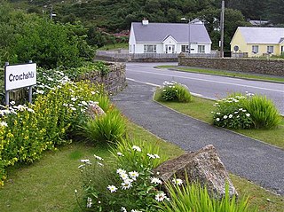
Croithlí or Croichshlí is a village in the Gaeltacht parishes and traditional districts of Gweedore and The Rosses in the west of County Donegal in Ulster, the northern province in Ireland. The two 'districts' are separated by the Crolly River. It has one convenience shop/restaurant and petrol station and one public house, Páidí Óg's. Crolly is located in two baronies: the Gweedore part of the village is in the Barony of Kilmacrenan, while The Rosses part of the village is in the Barony of Boylagh, the Crolly River being the boundary between the two baronies.
Meenagolan is a townland in Southwest of County Donegal, Ireland in the civil and church parish of Killaghtee. The main geographical feature is Croagh Lough. The lough is currently used as a reservoir for the nearby town of Ardara. Large tracts of the townland are now owned by Coilte, the Irish forestry state body, and planted with fir.
Castleforward Demesne is a townland just east of Newtowncunningham, a village in The Laggan, a district in the east of County Donegal in Ireland. The townland is near the south-eastern shores of Lough Swilly and is in the Barony of Raphoe North.
Eighter Island is a small island and a townland off the coast of County Donegal, Ireland. The closest town on the mainland is Burtonport.

Inishcoo is a small island and a townland off the coast of County Donegal, Ireland. The closest town on the mainland is Burtonport.

Inishkeel is a small tidal island and a townland off the coast of County Donegal, Ireland. The closest village on the mainland is Narin.
The Burn Dale is a burn or small river in the east of County Donegal in Ulster, the northern province in Ireland. The burn is also known in English as the Dale Burn, the Burn Deele, the Burndale River, the Deele River or the River Deele. In the Ulster Scots dialect, a 'burn' is a stream or small river.
The Drumenny Burn, also known as the Drumonny Burn, the Drumenny River, the Drummenny River or the Drimminy River, is a burn in the south of County Donegal in Ulster, the northern province in Ireland. The lower stretch of the burn flows around the eastern edge of Donegal Town, where it flows into the River Eske. In the Ulster Scots dialect, a 'burn' is a stream or small river. The Drumenny Burn probably takes its name from the townland of Drumenny Upper, through which it flows, or else from the townlands of Drumenny Middle and Drumenny Lower, around the edges of which it flows. Almost all of the burn flows within the Civil Parish of Donegal.

Drumkeen is a village and townland in County Donegal, Ireland. The village is near the N13 primary road, about 8 kilometres (5 mi) west of Convoy. The village population was 193 at the 2016 census. The local soccer club, Drumkeen United, play at St Patrick's Park. The village is located just above the Burn Dale, which flows along the southern edge of the village. Drumkeen is the 660th biggest town-land and has an area of 2.2662 km2.
